Digital Image: 1892 Mingjei Liu Humorous Woodlblock Map of China - first Chinese commercial map
China-mingjieliu-1892_d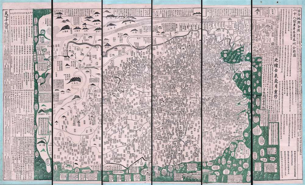

Title
古今地舆全圖 / Full Modern and Ancient Map.
1892 (dated) 43 x 72 in (109.22 x 182.88 cm)
1892 (dated) 43 x 72 in (109.22 x 182.88 cm)
Description
FOR THE ORIGINAL ANTIQUE MAP, WITH HISTORICAL ANALYSIS, CLICK HERE.
Digital Map Information
Geographicus maintains an archive of high-resolution rare map scans. We scan our maps at 300 DPI or higher, with newer images being 600 DPI, (either TIFF or JPEG, depending on when the scan was done) which is most cases in suitable for enlargement and printing.
Delivery
Once you purchase our digital scan service, you will receive a download link via email - usually within seconds. Digital orders are delivered as ZIP files, an industry standard file compression protocol that any computer should be able to unpack. Some of our files are very large, and can take some time to download. Most files are saved into your computer's 'Downloads' folder. All delivery is electronic. No physical product is shipped.
Credit and Scope of Use
You can use your digial image any way you want! Our digital images are unrestricted by copyright and can be used, modified, and published freely. The textual description that accompanies the original antique map is not included in the sale of digital images and remains protected by copyright. That said, we put significant care and effort into scanning and editing these maps, and we’d appreciate a credit when possible. Should you wish to credit us, please use the following credit line:
Courtesy of Geographicus Rare Antique Maps (https://www.geographicus.com).
How Large Can I Print?
In general, at 300 DPI, you should at least be able to double the size of the actual image, more so with our 600 DPI images. So, if the original was 10 x 12 inches, you can print at 20 x 24 inches, without quality loss. If your display requirements can accommodate some loss in image quality, you can make it even larger. That being said, no quality of scan will allow you to blow up at 10 x 12 inch map to wall size without significant quality loss. For more information, it is best consult a printer or reprographics specialist.
Refunds
If the high resolution image you ordered is unavailable, we will fully refund your purchase. Otherwise, digital images scans are a service, not a tangible product, and cannot be returned or refunded once the download link is used.
Cartographer
Mingjie Liu (1857 - 1911) (刘明杰) was a Qing Dynasty Chinese folk artist and printer. He was born in Hanting District, Weifang, Shandong, China. He is known for his paintings and folk characterizations, mubǎn nianhua (木版年画), made for Chinese New Year Festivals - a Shandong tradition - which he began producing at just 8. Politically, he was nationalist but anti-imperialist and anti-feudalist. He created many paintings and prints satirizing the ruling elite - including the Dowager Empress Cixi - and deploring foreign incursions into China. Most of his work was eventually seized and destroyed as subversive. His cartographic corpus is limited, but he is known for three maps, among them his Full Modern and Ancient Map (古今地舆全圖), which was issued as early as 1892 and is China's first commercially produced map. In 1811, Mingjie Liu traveled to the city of Yingkou, Liaoning province, in order to sell a painted fan. On the way he established himself in an abandoned temple. During a torrential rainstorm, the decrepit building collapsed, killing Liu. More by this mapmaker...