1660 Jansson / Van Loon Map of China and Korea
ChinaKorea-jansson-1660$1,200.00

Title
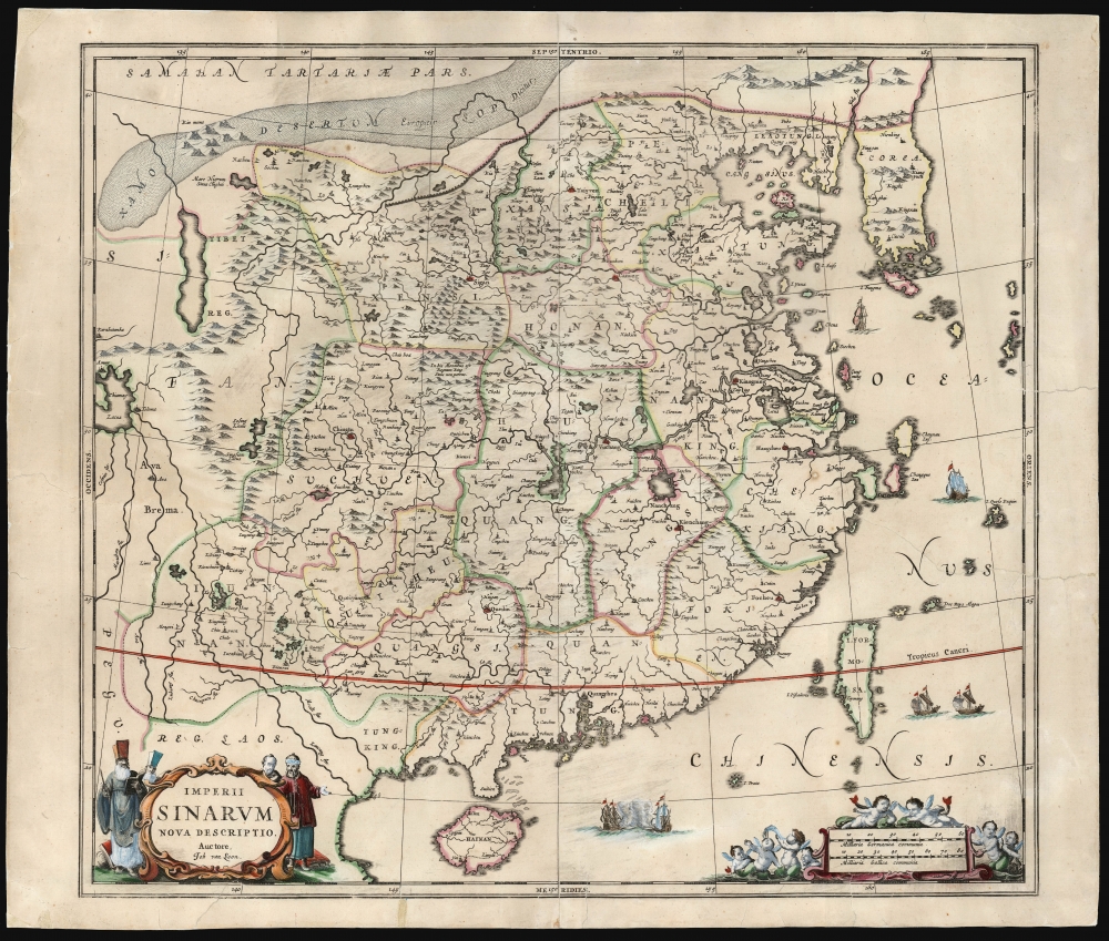
Imperii Sinarum Nova Descriptio.
1660 (undated) 18.25 x 20.5 in (46.355 x 52.07 cm) 1 : 6000000
1660 (undated) 18.25 x 20.5 in (46.355 x 52.07 cm) 1 : 6000000
Description
This is Jan Jansson and Jan van Loon's c. 1660 map of China and Korea: the earliest acquirable such maps to focus specifically on China inclusive of Korea. The map's narrower focus allows significantly more place names than the map with which it competed: Blaeu's 1655 map of the same title, which encompassed the Japanese islands at the expense of detail. This piece is among the most richly detailed atlas maps of China, including as it does the Great Wall, the legendary lake Chimay, and an early reference to Tibet. It is also a superbly decorative piece: it features a sea battle near Hainan and sailing junks near Formosa. The elegant cartouche is flanked by Chinese and Jesuit officials (marked by their distinctive hats). The scale cartouche features a riot of putti.
as for the content of the present work, Van Loon's map draws on the maps produced by Blaeu for the Jesuit Martino Martini, and as such it presents the state of the art of Western knowledge of the Chinese Empire, dating from Martini's travels there in the 1640s. The map's accuracy shows particularly well in the south, in the vicinity of Guangzhou, Macau, and modern Hong Kong.
Van Loon's Sources
It is probably correct to consider Van Loon to have been the creator of this map; certainly, it is likely that he engraved it for Jansson. The two had already collaborated on Van Loon's pilot guide, Le nouveau flambeau de la mer and Jansson would in 1667 publish Van Loon's sea atlas Klaer lichtende noortster ofte zee-atlas.as for the content of the present work, Van Loon's map draws on the maps produced by Blaeu for the Jesuit Martino Martini, and as such it presents the state of the art of Western knowledge of the Chinese Empire, dating from Martini's travels there in the 1640s. The map's accuracy shows particularly well in the south, in the vicinity of Guangzhou, Macau, and modern Hong Kong.
A Detailed Korean Peninsula
Among the major features of the Van Loon map is its unambiguous presentation of a peninsular Korea. While the 1655 Blaeu did depict Korea as a peninsula, it did so with a narrow spit of land coming to a point at the south; The shape of Korea as presented here is more accurate and rectilinear, with an archipelago to the south. This is consistent with the coastline and islands depicted on Jansson's 1644 Nova et Accurata Japoniae Terrae Esonis: the major distinctions being that a) the 1644 map employed an insular Korea and b) the two maps do not agree in the naming of the large island south of Korea (here named Fungma, but I. de Ladrones on the 1644 map. The present map also includes more place names in Korea, and is in this case consistent with those seen on the 1655 Blaeu.Publication History and Census
This map was engraved - probably by Van Loon - to be added to Jansson's Atlas Novus.The earliest examples were added to existing atlases without verso text, and so there is no concrete dating for them. Jansson would add the map to his Atlas Maior starting in 1666, and these later examples can be dated based on verso text. The present example, lacking text, can conservatively be dated c. 1660, although it could certainly have been produced any time after 1655.CartographerS
Jan Jansson or Johannes Janssonius (1588 - 1664) was born in Arnhem, Holland. He was the son of a printer and bookseller and in 1612 married into the cartographically prominent Hondius family. Following his marriage he moved to Amsterdam where he worked as a book publisher. It was not until 1616 that Jansson produced his first maps, most of which were heavily influenced by Blaeu. In the mid 1630s Jansson partnered with his brother-in-law, Henricus Hondius, to produce his important work, the eleven volume Atlas Major. About this time, Jansson's name also begins to appear on Hondius reissues of notable Mercator/Hondius atlases. Jansson's last major work was his issue of the 1646 full edition of Jansson's English Country Maps. Following Jansson's death in 1664 the company was taken over by Jansson's brother-in-law Johannes Waesberger. Waesberger adopted the name of Jansonius and published a new Atlas Contractus in two volumes with Jansson's other son-in-law Elizée Weyerstraet with the imprint 'Joannis Janssonii haeredes' in 1666. These maps also refer to the firm of Janssonius-Waesbergius. The name of Moses Pitt, an English map publisher, was added to the Janssonius-Waesbergius imprint for maps printed in England for use in Pitt's English Atlas. More by this mapmaker...
Johannes van Loon (c. 1611 - 1686), also known as Jan van Loon, was a Dutch mapmaker, mathematician, and engraver active in Amsterdam during the middle part of the 17th century. Van Loon issued the exceptional nautical atlas Klaer-Lichtende Noort-Ster ofte Zee Atlas in 1661. His is also known to have engraved several plates of Cellarius's Harmonia Macrocosmica Seu Atlas and to have contributed maps to nautical atlases and pilot books by Jacobsz, Jan Jansson, Johannes Janssonius van Waesbergen, and Robijin. Little is known of his personal life. Learn More...
Martino Martini (September 20, 1614 - June 6, 1661) was an Italian Jesuit missionary, historian, and cartographer, working mainly on ancient Imperial China. He is acclaimed as the father of Chinese geographical science, as he was ‘the first to study the history and geography of China with rigorous scientific objectivity.' Born in Trento, in the Bishopric of Trent, he finished school in 1631. After, he entered the Society of Jesus and was sent to study classical letters and philosophy at the Roman College, Rome, from 1634 until 1637. He completed his theological studies in Portugal from 1637 until 1639 and was ordained as a priest in Lisbon in 1639. He left for China in 1640, arriving in 1642 in Portuguese Macau. He studied Chinese before, in 1642, moving to Hangzhou, Zhejiang Province. He spent much of his time traveling and gathering scientific information, particularly concerning the geography. In April 1644, soon after his arrival in China, the Ming capital Beijing fell to Li Zicheng’s rebels and then to the Manchus. Martini had been allied with the short-lived regime of Zhu Yujian, Prince of Tang, who declared himself the (Southern) Ming Longwu Emperor after the fall of the last legitimate Ming, the Chongzhen Emperor. When Wenzhou, where Martini was on a mission for Zhu Yujian, was about to fall to the Manchus, Martini convinced them to allow him to change sides. Before the Manchu troops entered the city, Martini created a large red poster stating, 'Here lives a doctor of the divine Law who has come from the Great West.' Below the poster he arranged tables with European books, astronomical instruments, and other objects surrounding an altar with an image of Jesus. The commander of the Manchu troops was so impressed by the display that he politely asked Martini to change sides. In 1651, Martini left China as the Delegate of the Chinese Mission Superior. Among the works he brought with him was Lo Hongxian's (羅洪先; 1504 - 1564) 1555 revision of Zhu Siben's (朱思本;1273 - 1333) 1312 manuscript atlas of the Chinese Provinces, Guang Yu Tu (廣與圖; 'Enlarged Territorial Atlas'). En route, his ship was captured by the Dutch, who apparently also saw Martini's value: they took him first to Java, and then to Amsterdam, where he arrived in 1654. During this intervening period, Martini translated the Zhu Siben atlas into Latin, and added his own description of China. The Blaeu mapmaking firm swiftly published Martini's map as Novus Atlas Sinensis, and later published Martini's description of China both on its own and within the Blaeu Atlas. After his circuitous journey, he reached Rome in the spring of 1655. He carried with him a long and detailed communication from the Jesuit missionaries in China, defending the so-called Chinese Rights (veneration of ancestors and other practices allowed to new Christians). After five months of discussions and debates, the Propaganda Fide issued a degree in favor of the Jesuits, although the controversy did not abate. Learn More...
Source
Jansson, J., Atlas Novus., (Amsterdam: Jansson) c. 1660.
Condition
Fair. Mended tears and separations with very slight loss; sheet backed with archival tissue. Original color, refreshed.
References
OCLC, 7454099. Van der Krogt, P. C. J., Koeman's Atlantes Neerlandici, (3 Vols), #8410:1C.