Digital Image: 1795 Faden Map of the Greater Antilles (West Indies): Bahamas, Cuba, Hispaniola
CubaBahamasHispaniola-faden-1795_d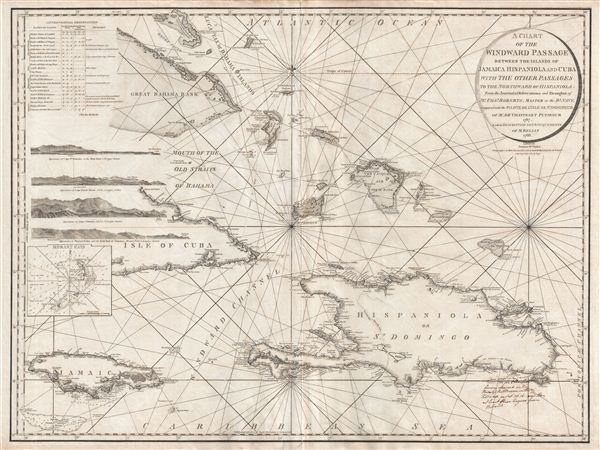

Title
A Chart of the Windward Passage Between the Islands of Jamaica Hispaniola and Cuba with the other Passages to the Northwest of Hispaniola.
1795 (dated) 23 x 31 in (58.42 x 78.74 cm)
1795 (dated) 23 x 31 in (58.42 x 78.74 cm)
Description
FOR THE ORIGINAL ANTIQUE MAP, WITH HISTORICAL ANALYSIS, CLICK HERE.
Digital Map Information
Geographicus maintains an archive of high-resolution rare map scans. We scan our maps at 300 DPI or higher, with newer images being 600 DPI, (either TIFF or JPEG, depending on when the scan was done) which is most cases in suitable for enlargement and printing.
Delivery
Once you purchase our digital scan service, you will receive a download link via email - usually within seconds. Digital orders are delivered as ZIP files, an industry standard file compression protocol that any computer should be able to unpack. Some of our files are very large, and can take some time to download. Most files are saved into your computer's 'Downloads' folder. All delivery is electronic. No physical product is shipped.
Credit and Scope of Use
You can use your digial image any way you want! Our digital images are unrestricted by copyright and can be used, modified, and published freely. The textual description that accompanies the original antique map is not included in the sale of digital images and remains protected by copyright. That said, we put significant care and effort into scanning and editing these maps, and we’d appreciate a credit when possible. Should you wish to credit us, please use the following credit line:
Courtesy of Geographicus Rare Antique Maps (https://www.geographicus.com).
How Large Can I Print?
In general, at 300 DPI, you should at least be able to double the size of the actual image, more so with our 600 DPI images. So, if the original was 10 x 12 inches, you can print at 20 x 24 inches, without quality loss. If your display requirements can accommodate some loss in image quality, you can make it even larger. That being said, no quality of scan will allow you to blow up at 10 x 12 inch map to wall size without significant quality loss. For more information, it is best consult a printer or reprographics specialist.
Refunds
If the high resolution image you ordered is unavailable, we will fully refund your purchase. Otherwise, digital images scans are a service, not a tangible product, and cannot be returned or refunded once the download link is used.
Cartographer S
Charles Roberts (1739 - 1825) was a British navigator and nautical surveyor active in the late 18th century. Roberts spent most of his life in the British West Indies and along the coasts of South America where is compiled and updated several nautical charts during his long career as a Master in the Royal Navy. He is specifically credited with three scarce charts focusing on various passages in the Greater Antilles. Rogers did most of his observational work among merchant vessels traversing the West Indies and personally records at least 24 such voyages. Roberts died at Leith in 1825 at the age of 86. More by this mapmaker...
William Faden (July 11, 1749 - March 21, 1836) was a Scottish cartographer and map publisher of the late 18th century. Faden was born in London. His father, William MacFaden, was a well-known London printer and publisher of The Literary Magazine. During the Jacobite Rebellion (1745 - 1746), MacFaden changed his family name to Faden, to avoid anti-Scottish sentiment. Faden apprenticed under the engraver James Wigley (1700 - 1782), attaining his freedom in 1771 - in the same year that Thomas Jefferys Sr. died. While Thomas Jefferys Sr. was an important and masterful mapmaker, he was a terrible businessman, and his son, Jefferys Jr., had little interest in building on his father's legacy. MacFaden, perhaps recognizing an opportunity, purchased his son a partnership in the Jefferys firm, which subsequently traded as 'Faden and Jefferys'. Jefferys Jr. also inherited Jefferys Sr.'s title, 'Geographer to the King and to the Prince of Wales'. With little interest in cartography or map publishing, Jefferys Jr. increasingly took a back seat to Faden, and by 1776, he had withdrawn from day-to-day management, although he retained his financial stake. The American Revolutionary War (1775 - 1783) proved to be a boom for the young 'Geographer to the King', who leveraged existing materials and unpublished manuscript maps to which he had access via his official appointment to publish a wealth of important maps, both for official use and the curious public - this period of prosperity laid the financial underpinning for Faden, who by 1783, at the end of the war, acquired full ownership of the firm and removed the Jefferys imprint. In 1801, he engraved and published the first maps for the British Ordnance Survey. By 1822, Faden published over 350 maps, atlases, and military plans. He retired in 1823, selling his plates to James Wyld Sr. Faden died in 1836. Learn More...
Jacques-Nicolas Bellin (1703 - March 21, 1772) was one of the most important cartographers of the 18th century. With a career spanning some 50 years, Bellin is best understood as geographe de cabinet and transitional mapmaker spanning the gap between 18th and early-19th century cartographic styles. His long career as Hydrographer and Ingénieur Hydrographe at the French Dépôt des cartes et plans de la Marine resulted in hundreds of high quality nautical charts of practically everywhere in the world. A true child of the Enlightenment Era, Bellin's work focuses on function and accuracy tending in the process to be less decorative than the earlier 17th and 18th century cartographic work. Unlike many of his contemporaries, Bellin was always careful to cite his references and his scholarly corpus consists of over 1400 articles on geography prepared for Diderot's Encyclopedie. Bellin, despite his extraordinary success, may not have enjoyed his work, which is described as "long, unpleasant, and hard." In addition to numerous maps and charts published during his lifetime, many of Bellin's maps were updated (or not) and published posthumously. He was succeeded as Ingénieur Hydrographe by his student, also a prolific and influential cartographer, Rigobert Bonne. Learn More...
References
Brown University, John Carter Brown Library, Cabinet Em795 RoC.