1873 Murray Map of Eastern Persia (Iran)
EasternPersia-murray-1873$350.00

Title
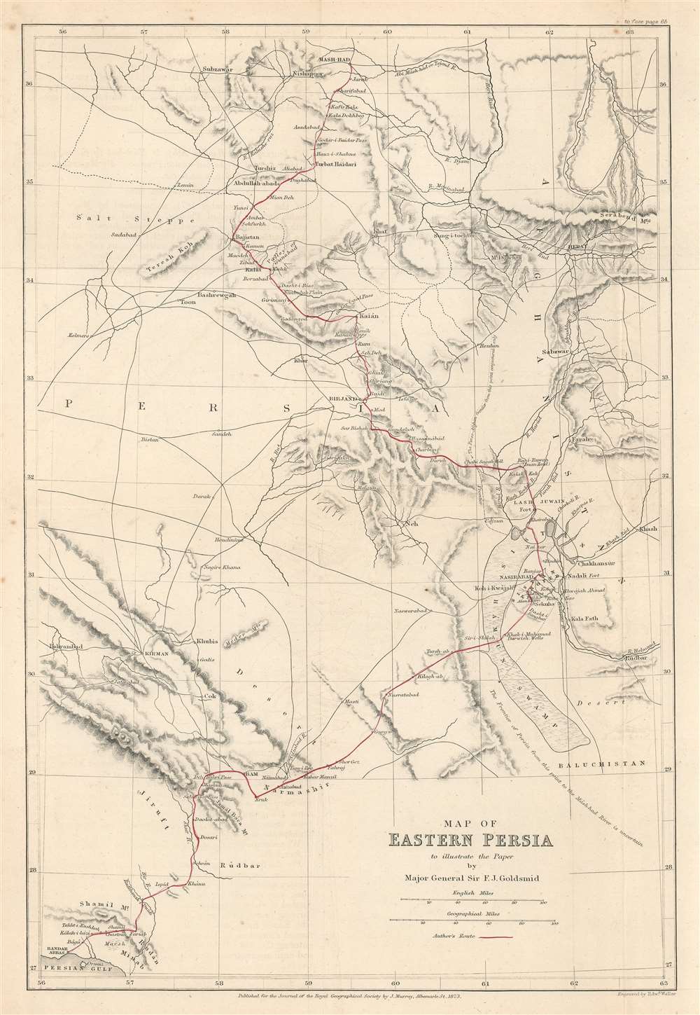
Map of Eastern Persia to illustrate the Paper by Major General Sir F. J. Goldsmid.
1873 (dated) 14.5 x 10 in (36.83 x 25.4 cm) 1 : 3200000
1873 (dated) 14.5 x 10 in (36.83 x 25.4 cm) 1 : 3200000
Description
This is an 1873 John Murray map of eastern Persia, or modern-day south-central Iran. A thin red line highlights Sir Frederic John Goldsmid's route through the region from Bandar Abbas on the Strait of Hormuz north to Mash-had. Goldsmid was dispatched to this region in order to enforce a British-negotiated Selstan frontier boundary settlement, a move in the 'Great Game' intended to secure Persia and Afghanistan as buffer provinces between Russia and British India.
The Goldsmid Boundary Mission
A year earlier in 1872, Goldsmid headed a commission that negotiated a new boundary between Afghanistan and Persia - the Selstan frontier. The line stretched from Banda to Kuh-i-Malik Siah (a hill at the modern Afghanistan-Iran-Pakistan tripoint) and followed the Helmand River. Although Goldsmid was considered one of the foremost authorities on Persia and the Middle East in the British Empire, his attempts to settle the Selstan boundary dispute ill-considered, as they failed to take into account the natural shifts of the Helmand River, as well as shifting tribal allegiances. Moreover, it was impossible to please both sides, with the new boundary alienating both the Shah Naser al-Din Shah Qajar (1831 - 1896) and Afghan Emir Mohammad Yaqub Khan (1849 - 1923). Despite opposition on all sides, Goldsmid and a team were sent to Persia to enforce the 1872 Boundary Settlement. This was a diplomatic, not a military mission, and primarily involved Goldsmid attempting to convince local tribal leaders on both sides to accept the border. The mission left ill-feelings all around, with Yaqub Khan attributed it to the beginning to souring relations with the British - a degenerative series of diplomatic mis-steps that ultimately led to the Second Anglo-Afghan War (1878 - 1880).The Great Game
'The Great Game' was a diplomatic confrontation between the British and Russian Empires over Afghanistan and other territories in Central and Southern Asia. The conflict, rooted in long-standing animosity between Russia and Britain, revolved around Afghanistan, which, while lacking significant resources of its own, was strategically situated. For its part, Russia feared Britain was making commercial and military inroads into Central Asia, an area long within the sphere of influence of St. Petersburg. Britain, conversely, feared Russia making gains in India, 'the jewel in the crown' of British Asia. The escalating tensions led to several wars and proxy wars: The First Anglo-Afghan War (1839 - 1842), the First Anglo-Sikh War (1845 - 1846), the Second Anglo-Sikh War (1848 - 1849), and the Second Anglo-Afghan War (1878 - 1880), along with the Russian annexations of Khiva, Bukhara, and Kokand. Then as now, Afghanistan proved a grinding stone upon which the world's great empires diminished themselves, none achieving a definitive victory despite committing staggering resources. The Great Game 'ended' on September 10, 1895 with the signing of the Pamir Boundary Commission Protocols, which stabilized the border between Afghanistan and the Russian Empire - but well into the 20th century the British were well aware the conflict remained. Regarding the attitude of Afghans to the British and to the Russians, the general assumption of the British was that 'Some will fight for us, some against us, but all will fight.'Publication History and Census
This map was created by John Murray and engraved by Edward Weller to accompany Goldsmid's article published in The Journal of the Royal Geographical Society in 1879. An empty OCLC reference exists for this map, suggesting it was cataloged by a former library cooperative member. An example is part of the institutional collection at Princeton University.CartographerS
John Murray I (1737 - 1793) founded the British publishing firm John Murray (1768 - present) in London. Born in Edinburgh, Murray served as an officer in the Royal Marines and built a list of authors that included Isaac D’Israeli and published the English Review. Murray the elder also was one of the founding sponsors of the London evening newspaper The Star in 1788. John Murray II (November 27 1778 - June 27, 1843) continued the family publishing business and developed it into one of the most important and influential publishing houses in Britain. The list of authors published by the firm grew to include Jane Austen, Sir Walter Scott, Washington Irving, George Crabbe, and Lord Byron under his tenure. Murray II also moved the business to 50 Albermarle Street in Mayfair, which became famous for Murray’s tradition of ‘four o’clock friends’, which was afternoon tea with his writers. John Murray III (1808 - 1892) continued to grow the business, and the firm published the first English translation of Goethe’s Theory of Colours, David Livingstone’s Missionary Travels and Charles Darwin’s Origin of Species during his tenure. Murray also published Herman Melville’s first two books. The firm began publishing Murray Handbooks in 1836, an ancestor of all modern travel guides. Sir John Murray IV (1851 - 1928) was publisher to Queen Victoria. Three successive Murray’s after Murray IV led the business until it was purchased by Hodder Headline in 2002, which was acquired by the French conglomerate Lagardère Group in 2004. Today, Murray is an imprint of Lagardère under the imprint Hachette UK. More by this mapmaker...
Edward Weller (July 1, 1819 - 1884) was a cartographer and engraver based in London. Weller was a nephew of another well-known map publisher Sidney Hall (1788 - 1831), who gave him 50 Pounds to pay his apprenticeship fees. He engraved for many prominent mapmakers and was active enough in the community to be recommended for membership to the Royal Geographical Society in 1851 on the recommendation of John Arrowsmith, among others. He eventually inherited the Sidney Hall map business which led him to follow Arrowsmith as the unofficial geographer to the Royal Geographical Society. Weller was among the first map printers in London to embrace lithography. His best known work appears in Cassell's Weekly Dispatch Atlas, published in monthly segments for subscribers of the 'Weekly Dispatch' newspaper. This collection of maps eventually grew to include much of the known world. Published in various editions from 1855 through the early 1880s. Weller died in May of 1884, leaving behind a successful business and an unhappy widow. His son, Francis Sidney Weller (1849 - 1910), followed in his father's footsteps and continued the family map business. The atlas Mackenzie's Comprehensive Gazetteer of England and Wales was published in 1894 and bore F. S. Weller's signature on the maps. Learn More...
Royal Geographical Society (fl. 1830 - present) is a British Society established in 1830 to promote geographical science and exploration. Originally titled the "Geographical Society of London", the RGS received its royal charter from Queen Victoria in 1859 shortly after absorbing several similar but more regional societies including the African Association, the Raleigh Club and the Palestine Association. The RGS sponsored many of the most important and exciting voyages of exploration ever undertaken, including the exploration of Charles Darwin, David Livingstone, Robert Falcon Scott, Richard F. Burton, John Speke, George Hayward, H. M Stanley, Ernest Shackleton and Sir Edmond Hillary. Today, the RGS remains a leading global sponsor of geographical and scientific studies. The Society is based in Lowther Lodge, South Kensington, London. Learn More...
Source
Goldsmid, F.J., 'Journey from Bandar Abbas to Mash-had by Sistan, with some Account of the last-named Province', The Journal of the Royal Geographical Society Vol. 43 (London: John Murray) 1873.
Condition
Very good. Exhibits light wear along original fold lines. Blank on verso.
References
Princeton University Library G7621.C1 1873 .R6. OCLC 1199994612.