Digital Image: 1875 Spanish Dir. de Hidrografia Nautical Chart of Iloilo Strait, Philippines
EstrechoIloIlo-hidrografia-1875_d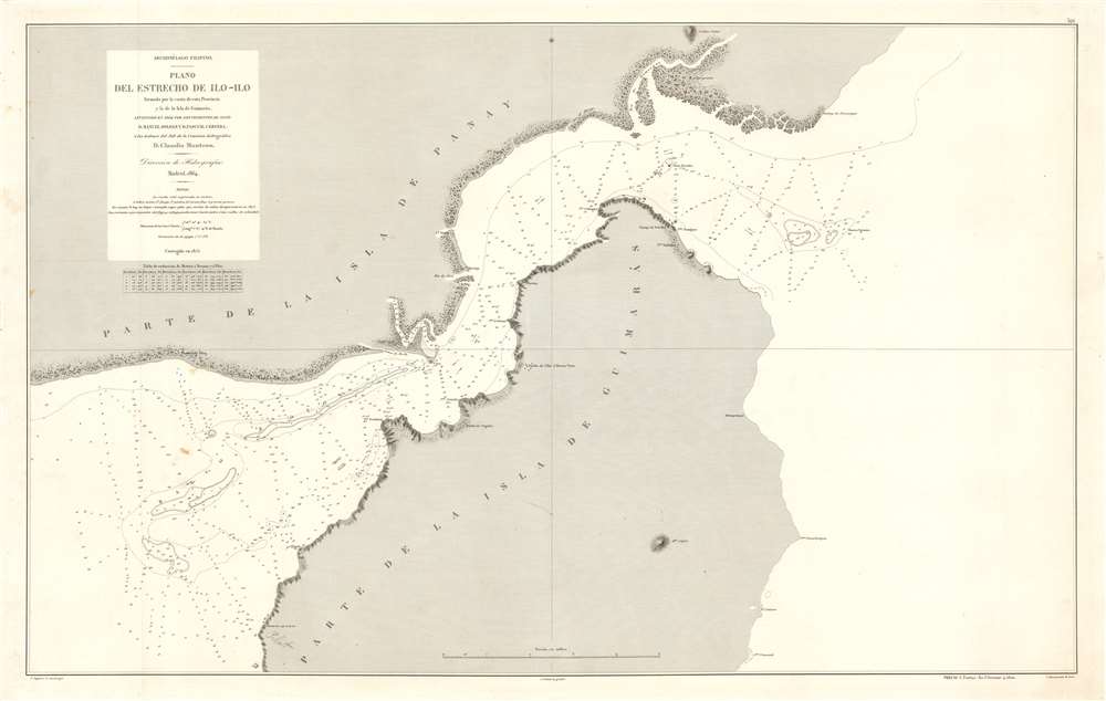

Title
Archipiélago Filipino. Plano del Estrecho de Ilo - Ilo.
1875 (dated) 25 x 39 in (63.5 x 99.06 cm) 1 : 43000
1875 (dated) 25 x 39 in (63.5 x 99.06 cm) 1 : 43000
Description
FOR THE ORIGINAL ANTIQUE MAP, WITH HISTORICAL ANALYSIS, CLICK HERE.
Digital Map Information
Geographicus maintains an archive of high-resolution rare map scans. We scan our maps at 300 DPI or higher, with newer images being 600 DPI, (either TIFF or JPEG, depending on when the scan was done) which is most cases in suitable for enlargement and printing.
Delivery
Once you purchase our digital scan service, you will receive a download link via email - usually within seconds. Digital orders are delivered as ZIP files, an industry standard file compression protocol that any computer should be able to unpack. Some of our files are very large, and can take some time to download. Most files are saved into your computer's 'Downloads' folder. All delivery is electronic. No physical product is shipped.
Credit and Scope of Use
You can use your digial image any way you want! Our digital images are unrestricted by copyright and can be used, modified, and published freely. The textual description that accompanies the original antique map is not included in the sale of digital images and remains protected by copyright. That said, we put significant care and effort into scanning and editing these maps, and we’d appreciate a credit when possible. Should you wish to credit us, please use the following credit line:
Courtesy of Geographicus Rare Antique Maps (https://www.geographicus.com).
How Large Can I Print?
In general, at 300 DPI, you should at least be able to double the size of the actual image, more so with our 600 DPI images. So, if the original was 10 x 12 inches, you can print at 20 x 24 inches, without quality loss. If your display requirements can accommodate some loss in image quality, you can make it even larger. That being said, no quality of scan will allow you to blow up at 10 x 12 inch map to wall size without significant quality loss. For more information, it is best consult a printer or reprographics specialist.
Refunds
If the high resolution image you ordered is unavailable, we will fully refund your purchase. Otherwise, digital images scans are a service, not a tangible product, and cannot be returned or refunded once the download link is used.
Cartographer S
Captain D. Claudio Montero (1824-1885) was a Spanish naval officer, and head of the Hydrographic and Scientific departments of the Spanish Navy. Upon entering the navy in 1839 at the age of 15, he was promptly tasked with hydrographic projects, clearly being groomed for position as a navigator and chartmaker. In 1845 he was made a Lieutenants, and assigned to the Philippines, where he would remain for a significant part of his military career. In 1856 he was appointed head of the newly-formed Comisión Hidrográfica de Filipinas. Both under his direction, and following it - between 1856 and 1899 - the Comisión published thirty-five nautical charts of the Philippine archipelago. By 1868, he had been appointed major general of the Philippine station, a position he retained until his return to the Spain to receive his 1869 appointment as head Hydrography and Science in the Ministry of the Navy.He continued to focus on Philippine affairs: in 1871, he joined the Philippine Council, of which he would become vice president - and in 1877, he returned to the Philippine Islands, this time as governor of Mindanao and commander of the Naval Division of the South of the Philippines. However, in early 1878, just a few months after his appointment, health problems forced him to submit his resignation in both positions. He returned to sea after his recovery for a time, and held positions as Rear Admiral in Spain and in Havana prior to his death. More by this mapmaker...
The Direccion Hidrografía (1787 - 1927), also known as the Deposito Hydrografico and the Direction de Hidrografía, was the Spanish equivalent of the British Admiralty or the U.S. Coast Survey. This organization, founded in 1787, was commissioned to collect and produce accurate nautical charts of all waters frequented by Spanish vessels. In essence, it replaced the Casa de la Contratación de las Indias (House of Trade of the Indies), which closed its doors in 1790. Like most such organizations, the Direccion Hidrografía marked a new age in cartography. Rather than simply collect charts created by navigators, explorers, and merchants, the Direccion Hidrografía worked closely with naval and military personnel to mount cartographic and hydrographic expeditions in pursuit of the most accurate hydrographical, astronomical, and geodetic measurements. The Direccion Hidrografía created a massive library of nautical charts that, though not nearly as common as similar nautical charts by the U.S. Coast Survey and British Admiralty, are highly desirable for the beauty of their manufacture as well as their accuracy and detail. The office was originally located on Calle Ballesta, but relocated to 36 Alcala, both in Madrid. After 1908 the Dirección was subsumed into other governmental agencies. In 1927 the Direccion was absorbed into the Institute and Observatory of San Fernando, located in Cadiz. The library of original maps, charts, and journals was transferred to the Naval Museum of Madrid - where it resides to this day. Learn More...
Juan Noguera (fl. c. 1835 – 1870) was a Spanish draftsman and engraver based in Madrid during the middle part of the 19th century. Noguera drafted and engraved maps for Francisco Coello, Direccion de Hidrografia, and others. Juan Noguera should not be confused with Clemente Noguera, who was also a senior line-engraver at the Direccion de Hidrografia. The two engravers may or may not be related. Clemente was significantly older than Juan, and may have been an older relative. Learn More...
Ignacio Tubau y Albert (fl. c. 1850 - 1872) was a Spanish engraver. Born in Barcelona, he was a follower of the Adacemia de San Fernando and was an engraver for the Direction de Hidrografia. Learn More...