Digital Image: 1865 Schultze Map of Fort Fisher at Pleasure Island, North Carolina
FortFisherVicinity-schultze-1865_d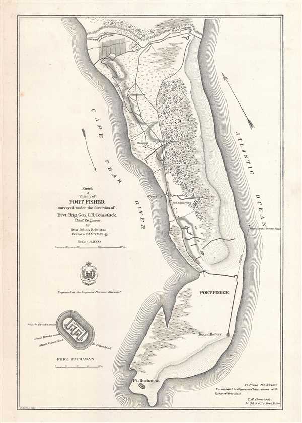

Title
Sketch of Vicinity of Fort Fisher.
1865 (dated) 15 x 10.25 in (38.1 x 26.035 cm) 1 : 12000
1865 (dated) 15 x 10.25 in (38.1 x 26.035 cm) 1 : 12000
Description
FOR THE ORIGINAL ANTIQUE MAP, WITH HISTORICAL ANALYSIS, CLICK HERE.
Digital Map Information
Geographicus maintains an archive of high-resolution rare map scans. We scan our maps at 300 DPI or higher, with newer images being 600 DPI, (either TIFF or JPEG, depending on when the scan was done) which is most cases in suitable for enlargement and printing.
Delivery
Once you purchase our digital scan service, you will receive a download link via email - usually within seconds. Digital orders are delivered as ZIP files, an industry standard file compression protocol that any computer should be able to unpack. Some of our files are very large, and can take some time to download. Most files are saved into your computer's 'Downloads' folder. All delivery is electronic. No physical product is shipped.
Credit and Scope of Use
You can use your digial image any way you want! Our digital images are unrestricted by copyright and can be used, modified, and published freely. The textual description that accompanies the original antique map is not included in the sale of digital images and remains protected by copyright. That said, we put significant care and effort into scanning and editing these maps, and we’d appreciate a credit when possible. Should you wish to credit us, please use the following credit line:
Courtesy of Geographicus Rare Antique Maps (https://www.geographicus.com).
How Large Can I Print?
In general, at 300 DPI, you should at least be able to double the size of the actual image, more so with our 600 DPI images. So, if the original was 10 x 12 inches, you can print at 20 x 24 inches, without quality loss. If your display requirements can accommodate some loss in image quality, you can make it even larger. That being said, no quality of scan will allow you to blow up at 10 x 12 inch map to wall size without significant quality loss. For more information, it is best consult a printer or reprographics specialist.
Refunds
If the high resolution image you ordered is unavailable, we will fully refund your purchase. Otherwise, digital images scans are a service, not a tangible product, and cannot be returned or refunded once the download link is used.
Cartographer
Cyrus Ballou Comstock (February 3, 1831 - May 29, 1910) was an officer in the Army of the United States. Born in Wrentham, Massachusetts, Comstock attended the United States Military Academy at West Point, from which he graduated first in his class in 1855. After graduating, Comstock served in the Army Corps of Engineers and he assisted with the design and construction of fortifications. Before the American Civil War, Comstock also held a post as an instructor of engineering at West Point. At the outbreak of the Civil War, Comstock was transferred from West Point to Washington, D.C., where ehe served on the staff of Brigadier General John G. Barnard, and helped design the fortifications of Washington. During General McClellan's Peninsular Campaign in 1862, Comstock served as chief engineer of the II Corps. Then, after Burnside succeeded McClellan, Comstock was named the Chief Engineer of the Army of the Potomac. In this position he was faced with the challenging task of constructing pontoon bridges over the Rappahannock River during the Fredericksburg Campaign, which ended in disaster. Due to logistical confusion, the supplies necessary for the construction of pontoon bridges did not arrive at the correct location on time. In the course of the month-long wait for supplies, the Union army lost the element of surprise and the Confederates were able to dig in at Fredericksburg, Virginia. When General Hooker took over command of the Army of the Potomac in 1863, Comstock was removed from his position as chief engineer and was put in charge of a battalion of engineers. After the Battle of Chancellorsville, Comstock was transferred to the Army of the Tennessee, which was in the middle of the Siege of Vicksburg, Mississippi, at the time. He set about improving the Union siege works, and impressed General Grant. Due to the impression he left on General Grant, Comstock was asked to served as Grant's senior aide-de-camp after he was appointed general-in-chief of the United States Army in March 1864. Comstock served on Grant's staff until the end of the war, but would be sent to help with several key operations before the end of the war. Grant sent Comstock to North Carolina to help plan the second (and successful) assault on Fort Fisher in January 1865 where he served under the command of Major General Alfred Terry. After the war, Comstock stayed in the army and served on Grant's staff until 1866, when he returned to the Corps of Engineers. He remained on active duty until 1895 and retired with the rank of colonel. In his post-war service he held positions on several boards and commissions, including the Permanent Board of Engineers in New York City, the geodetic survey of the north and northwestern lakes of the United States, and as president of the Mississippi River Commission for many years. Comstock was also a prominent member fo the National Academy of Sciences, bequeathing funds for a prize that the Academy was to award to a scientist who was conducting innovative work in the fields of electricity, magnetism, or radiant energy. Today, this prize is known as the Comstock Prize in Physics, and is awarded every five years by the Academy with a prize of $20,000. Comstock married Elizabeth 'Minnie' Blair in 1869, which whom he had one daughter, Elizabeth Marion Comstock, who was born in Detroit, Michigan in 1872 More by this mapmaker...
References
LOC G3904.F62S5 1865 .S3. Stephenson, R. W., Civil War Maps; an Annotated List of Maps and Atlases in Map Collections of the Library of Congress, 314. OCLC 55024487.