Digital Image: 1730 De Petit and Homann Heirs Map of the Strait of Gibraltar and Cadiz
Gibraltar-homannheirs-1730_d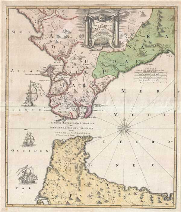

Title
Carte nouvelle De L'Isle de Cadix et du Detroit de Gibraltar.
1730 (undated) 23 x 19.5 in (58.42 x 49.53 cm) 1 : 495000
1730 (undated) 23 x 19.5 in (58.42 x 49.53 cm) 1 : 495000
Description
FOR THE ORIGINAL ANTIQUE MAP, WITH HISTORICAL ANALYSIS, CLICK HERE.
Digital Map Information
Geographicus maintains an archive of high-resolution rare map scans. We scan our maps at 300 DPI or higher, with newer images being 600 DPI, (either TIFF or JPEG, depending on when the scan was done) which is most cases in suitable for enlargement and printing.
Delivery
Once you purchase our digital scan service, you will receive a download link via email - usually within seconds. Digital orders are delivered as ZIP files, an industry standard file compression protocol that any computer should be able to unpack. Some of our files are very large, and can take some time to download. Most files are saved into your computer's 'Downloads' folder. All delivery is electronic. No physical product is shipped.
Credit and Scope of Use
You can use your digial image any way you want! Our digital images are unrestricted by copyright and can be used, modified, and published freely. The textual description that accompanies the original antique map is not included in the sale of digital images and remains protected by copyright. That said, we put significant care and effort into scanning and editing these maps, and we’d appreciate a credit when possible. Should you wish to credit us, please use the following credit line:
Courtesy of Geographicus Rare Antique Maps (https://www.geographicus.com).
How Large Can I Print?
In general, at 300 DPI, you should at least be able to double the size of the actual image, more so with our 600 DPI images. So, if the original was 10 x 12 inches, you can print at 20 x 24 inches, without quality loss. If your display requirements can accommodate some loss in image quality, you can make it even larger. That being said, no quality of scan will allow you to blow up at 10 x 12 inch map to wall size without significant quality loss. For more information, it is best consult a printer or reprographics specialist.
Refunds
If the high resolution image you ordered is unavailable, we will fully refund your purchase. Otherwise, digital images scans are a service, not a tangible product, and cannot be returned or refunded once the download link is used.
Cartographer S
Johann Friedrich Weidler (April 23, 1691 - December 30, 1755) was a German mathematician and legal scholar. Born in Großneuhausen, Weidler enrolled at the University of Jena in 1706 at the age of fifteen. He then enrolled at the University of Wittenburg from which he graduated with a Master's degree in 1712. He was named an adjunct professor at the Philosophical Faculty of the Wittenberg Academy in 1715. He took a break from teaching in 1726 and 1727 and traveled to Holland, England, France, and Switzerland. He received a doctorate in law from a university in Basel in 1727. Weidler then returned to Wittenberg and took a post as an associate professor in the Law School. He published a book based on his mathematics lectures, Institutiones mathematicae, which was published in five editions during his lifetime and several more following his death. Weidler also wrote extensively on astronomy and was named as a foreign member of the Royal Prussian Society of Sciences in 1730. More by this mapmaker...
Homann Heirs (1730 - 1848) were a map publishing house based in Nuremberg, Germany, in the middle to late 18th century. After the great mapmaker Johann Baptist Homann's (1664 - 1724) death, management of the firm passed to his son Johann Christoph Homann (1703 - 1730). J. C. Homann, perhaps realizing that he would not long survive his father, stipulated in his will that the company would be inherited by his two head managers, Johann Georg Ebersberger (1695 - 1760) and Johann Michael Franz (1700 - 1761), and that it would publish only under the name 'Homann Heirs'. This designation, in various forms (Homannsche Heirs, Heritiers de Homann, Lat Homannianos Herod, Homannschen Erben, etc..) appears on maps from about 1731 onwards. The firm continued to publish maps in ever diminishing quantities until the death of its last owner, Christoph Franz Fembo (1781 - 1848). Learn More...
References
Bibliothèque nationale de France CPL GE DD-2987.