This item has been sold, but you can get on the Waitlist to be notified if another example becomes available, or purchase a digital scan.
1730 De Petit and Homann Heirs Map of the Strait of Gibraltar and Cadiz
Gibraltar-homannheirs-1730$200.00

Title
Carte nouvelle De L'Isle de Cadix et du Detroit de Gibraltar.
1730 (undated) 23 x 19.5 in (58.42 x 49.53 cm) 1 : 495000
1730 (undated) 23 x 19.5 in (58.42 x 49.53 cm) 1 : 495000
Description
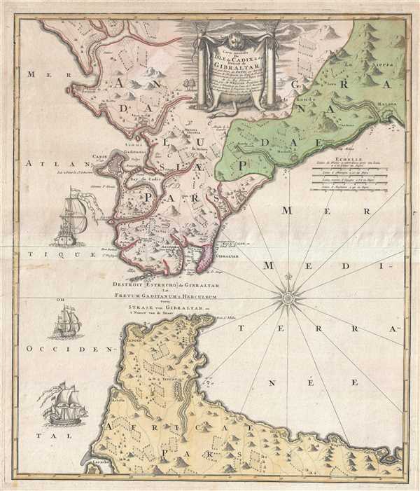
This is a 1730 Jean de Petit and Homann Heirs map of the Strait of Gibraltar and Cadiz. The map depicts the region from the Atlantic Ocean to the Alboran Sea (the westernmost part of the Mediterranean Sea) and from Spain and Gibraltar to Morocco. A beautifully engraved piece, numerous cities, towns, and villages are labeled throughout Spain, including Cadiz, Malaga, and Tangier. Farmland is illustrated in both countries as well, with each plot of land exhibiting rows of crops and encircled by trees. Roads connect the cities and towns, while mountains and trees populate the countryside. Anchors are illustrated in the Bay of Gibraltar and at several other points along the European Mediterranean coast, indicating safe harbors for mariners. Depth soundings are also noted by these harbors. A small illustration of a sword is included under 'Cadix', referring to the Battle of Cadiz in 1596. While there have been several Battles of Cadiz throughout history (by 1730 there had been seven), the joint English-Dutch raid in 1596 was the only successful sacking of the city. Three magnificent ships of the line are illustrated plying the waters of the Atlantic, their sails billowing in the wind. A title cartouche is situated along the upper border, with the text appearing on a lion's pelt that has been stretched between two posts.
This map was created by Jean de Petit and published by Johann Weidler and Homann Heirs in 1730.
This map was created by Jean de Petit and published by Johann Weidler and Homann Heirs in 1730.
CartographerS
Johann Friedrich Weidler (April 23, 1691 - December 30, 1755) was a German mathematician and legal scholar. Born in Großneuhausen, Weidler enrolled at the University of Jena in 1706 at the age of fifteen. He then enrolled at the University of Wittenburg from which he graduated with a Master's degree in 1712. He was named an adjunct professor at the Philosophical Faculty of the Wittenberg Academy in 1715. He took a break from teaching in 1726 and 1727 and traveled to Holland, England, France, and Switzerland. He received a doctorate in law from a university in Basel in 1727. Weidler then returned to Wittenberg and took a post as an associate professor in the Law School. He published a book based on his mathematics lectures, Institutiones mathematicae, which was published in five editions during his lifetime and several more following his death. Weidler also wrote extensively on astronomy and was named as a foreign member of the Royal Prussian Society of Sciences in 1730. More by this mapmaker...
Homann Heirs (1730 - 1848) were a map publishing house based in Nuremberg, Germany, in the middle to late 18th century. After the great mapmaker Johann Baptist Homann's (1664 - 1724) death, management of the firm passed to his son Johann Christoph Homann (1703 - 1730). J. C. Homann, perhaps realizing that he would not long survive his father, stipulated in his will that the company would be inherited by his two head managers, Johann Georg Ebersberger (1695 - 1760) and Johann Michael Franz (1700 - 1761), and that it would publish only under the name 'Homann Heirs'. This designation, in various forms (Homannsche Heirs, Heritiers de Homann, Lat Homannianos Herod, Homannschen Erben, etc..) appears on maps from about 1731 onwards. The firm continued to publish maps in ever diminishing quantities until the death of its last owner, Christoph Franz Fembo (1781 - 1848). Learn More...
Condition
Very good. Closed tear extending 2.25 inches in upper portion of map professionaly repaired on verso. Blank on verso.
References
Bibliothèque nationale de France CPL GE DD-2987.