1561 / 1574 Ruscelli Holy Land / Israel / Palestine
HolyLand-ruscelli-1561-2$650.00

Title
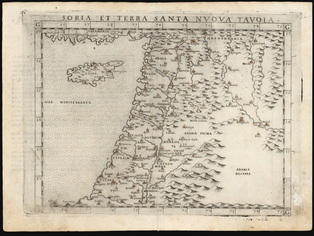
Soria et Terra Santa Nuova Tavola.
1561 (undated) 7.25 x 9.5 in (18.415 x 24.13 cm) 1 : 5000000
1561 (undated) 7.25 x 9.5 in (18.415 x 24.13 cm) 1 : 5000000
Description
This is a handsome example of Girolamo Ruscelli's 1561 / 1574 map of the Holy Land and Cyprus. It is an enlarged, more finely-engraved iteration of Giocomo Gastaldi's 1548 Soria e Terra Sancta nova tabula. While Tibbetts avers that the Ruscelli contains fewer place names than its Gastaldi source, he is incorrect: Ruscelli's map preserves all the data of the Gastaldi, but between the increased size of the plate and the clear, legible, and well-spaced engraving of the newer map, its data is presented without the crowding evident on the 1548 map. The skill evident in this work can be credited to the engraver Giulio Sanuto, one of the few Venetian engravers whose career was not isolated either to map engraving or to figurative artistic works, but consisted of both over a career of more than forty years.
Scope of the Work
The map covers the Mediterranean coast from Larissa in the south to 'Candeloro' on the coast of Asia Minor. Cyprus is shown in reasonable detail, with seven cities including Famagusta and Nicosia. Inland, the map depicts Syria and Palestine on both sides of the Jordan, divided amongst the Twelve Tribes of Israel. Detail extends to the Sepulcher of Job, Mount Lebanon, and the Cedar Tabernacles of Gad and Manasse. It extends eastwards beyond the Euphrates River to include Desert Arabia, although there is no specific detail available there.Publication History and Census
The map was engraved by Giulio Sanuto for inclusion in Ruscelli's La geografia di Claudio Tolomeo Alessandrino, and the plate appeared in all editions of that work. The separate map is cataloged in nine institutional collections, although it does appear on the market from time to time. The maps of the 1561 edition were engraved two-to-a-plate, and consequently, the platemark runs off the edge of the sheet at top for the 1561, 1562 and 1564 printings of the work. Afterward, the plates were divided, and examples from 1574 onwards, as here, exhibit a platemark all around the map. Furthermore, the plate shows considerable evidence of reworking, in many cases simplifying the form of the mountains to improve the clarity of the image. In 1599, a ship was added to the Mediterranean. The present example conforms typographically to the 1574 edition. We see nine examples of this separate map cataloged in OCLC, in various editions.CartographerS
Girolamo Ruscelli (1500 - 1566) was an Italian polymath, humanist, editor, and cartographer active in Venice during the early 16th century. Born in Viterbo, Ruscelli lived in Aquileia, Padua, Rome and Naples before relocating to Venice, where he spent much of his life. Cartographically, Ruscelli is best known for his important revision of Ptolemy's Geographia, which was published posthumously in 1574. Ruscelli, basing his work on Gastaldi's 1548 expansion of Ptolemy, added some 37 new "Ptolemaic" maps to his Italian translation of the Geographia. Ruscelli is also listed as the editor to such important works as Boccaccio's Decameron, Petrarch's verse, Ariosto's Orlando Furioso, and various other works. In addition to his well-known cartographic work many scholars associate Ruscelli with Alexius Pedemontanus, author of the popular De' Secreti del R. D. Alessio Piemontese. This well-known work, or "Book of Secrets" was a compilation of scientific and quasi-scientific medical recipes, household advice, and technical commentary on a range of topics that included metallurgy, alchemy, dyeing, perfume making. Ruscelli, as Alexius, founded a "Academy of Secrets," a group of noblemen and humanists dedicated to unearthing "forbidden" scientific knowledge. This was the first known experimental scientific society and was later imitated by a number of other groups throughout Europe, including the Accademia dei Secreti of Naples. More by this mapmaker...
Giacomo Gastaldi (c. 1500 - October, 1566) was an Italian astronomer, cartographer, and engineer active in the second half of the 16th century. Gastaldi (sometimes referred to as Jacopo or Iacobo) began his career as an engineer, serving the Venetian Republic in that capacity until the fourth decade of the sixteenth century. During this time he traveled extensively, building a large library relating to voyages and exploration. From about 1544 he turned his attention to mapmaking, working extensively with Gextantiovanni Battista Ramusio, Nicolo Bascarini, and Giovanbattista Pedrezano, as well as taking private commissions for, among others, Venice's Council of Ten. He is credited with the fresco maps of Asia and Africa still extant in the map room of the Doge's Palace. Gastaldi was also one of the first cartographers to embrace copper plate over woodblock engraving, marking an important development in the history of cartography. His 1548 edition of Ptolemy's Geographia was the first to be printed in a vernacular; it was the first to be printed in copperplate. As with his Swiss/German contemporary Münster, Gastaldi's work contained many maps depicting newly discovered regions for the first time, including the first map to focus on the East Coast of North America, and the first modern map of the Indian Peninsula. His works provided the source for the vast majority of the Venetian and Roman map publishers of the 1560s and 70s, and would continue to provide an outsize influence on the early maps of Ortelius, De Jode, and Mercator. Learn More...
Giulio Sanuto (fl. 1540 – 1580) was a Venetian engraver. He was born the illegitimate son of Cavaliere Francesco di Angelo Sanuto; With his brother, the cartographer and scientific instrument maker Livio Sanuto (1520 – 1576) he produced an array of some of the most important geographical works produced in Venice during the second half of the sixteenth century. These included a 27-inch globe and the 1588 12-sheet atlas, Geografia della Africa. Giulio's career is singluar among Venice's engraves in that it appears to have been equally based on artistic, figurative work as well as his cartographic works. Giulio is more broadly known for a small but sought-after selection of decorative engravings; no more than twelve of these can be attributed confidently to him, including the monumental Apollo and Marsyas, measuring over 1.30 meters wide. Whilst Sanuto's engravings were generally based upon the designs of other artists, his work was both ambitious and grand, and he often signed these works. Learn More...
Source
Ruscelli, G., La Geografia di Claudio Tolomeo Alessandrino…, (Venice: Valgrisi) 1574.
Condition
Very good. Some scuffing outside border to lower right within platemark. Neat manuscript notation and embellishment of cities in an old hand.
References
OCLC 500400149. Rumsey 11311.111. (1561) Laor, E., Maps of the Holy Land: Cartobibliography of Printed Maps, 1475 - 1900, #621. Tibbetts, G. R., Arabia in Early Maps: A Bibliography of Maps Covering the Peninsula of Arabia, Printed in Western Europe from the Invention of Printing to the Year 1751, #26. Zacharakis, C. G., A Catalogue of Printed Maps of Greece 1477-1800, #2837.