Digital Image: 1858 Tobler City Plan or Map of Jerusalem and Environs
Jerusalem-vandevelde-1858_d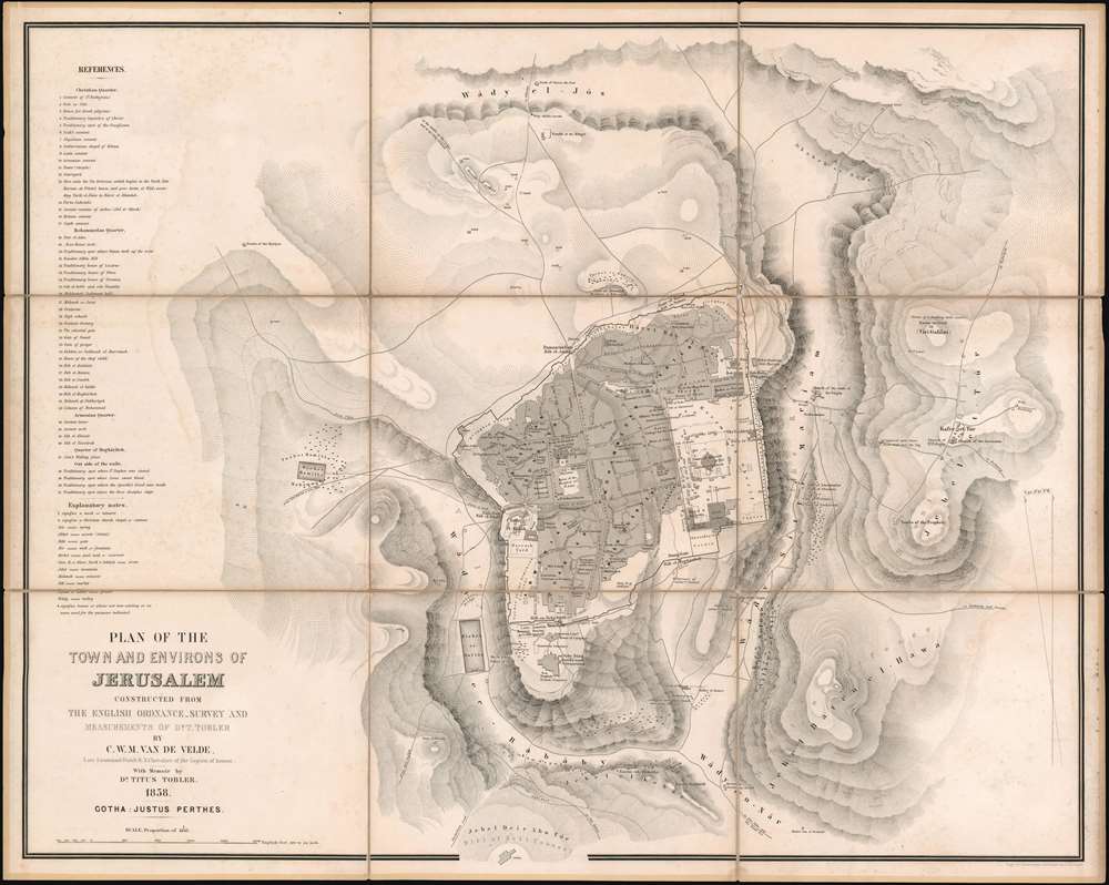

Title
Plan of the Town and Environs of Jerusalem Constructed From the English Ordnance Survey and Measurements of Dr. T. Tobler.
1858 (dated) 26.25 x 33 in (66.675 x 83.82 cm) 1 : 4843
1858 (dated) 26.25 x 33 in (66.675 x 83.82 cm) 1 : 4843
Description
FOR THE ORIGINAL ANTIQUE MAP, WITH HISTORICAL ANALYSIS, CLICK HERE.
Digital Map Information
Geographicus maintains an archive of high-resolution rare map scans. We scan our maps at 300 DPI or higher, with newer images being 600 DPI, (either TIFF or JPEG, depending on when the scan was done) which is most cases in suitable for enlargement and printing.
Delivery
Once you purchase our digital scan service, you will receive a download link via email - usually within seconds. Digital orders are delivered as ZIP files, an industry standard file compression protocol that any computer should be able to unpack. Some of our files are very large, and can take some time to download. Most files are saved into your computer's 'Downloads' folder. All delivery is electronic. No physical product is shipped.
Credit and Scope of Use
You can use your digial image any way you want! Our digital images are unrestricted by copyright and can be used, modified, and published freely. The textual description that accompanies the original antique map is not included in the sale of digital images and remains protected by copyright. That said, we put significant care and effort into scanning and editing these maps, and we’d appreciate a credit when possible. Should you wish to credit us, please use the following credit line:
Courtesy of Geographicus Rare Antique Maps (https://www.geographicus.com).
How Large Can I Print?
In general, at 300 DPI, you should at least be able to double the size of the actual image, more so with our 600 DPI images. So, if the original was 10 x 12 inches, you can print at 20 x 24 inches, without quality loss. If your display requirements can accommodate some loss in image quality, you can make it even larger. That being said, no quality of scan will allow you to blow up at 10 x 12 inch map to wall size without significant quality loss. For more information, it is best consult a printer or reprographics specialist.
Refunds
If the high resolution image you ordered is unavailable, we will fully refund your purchase. Otherwise, digital images scans are a service, not a tangible product, and cannot be returned or refunded once the download link is used.
Cartographer S
Charles William Meredith van de Velde (December 3, 1818 - March 20, 1898) was a Dutch cartographer, painter, missionary, lieutenant commander second class, and honorary member of the Red Cross. Born in Leeuwarden, Van de Velde was educated at the Naval Academy at Medemblik and earned the rank of lieutenant commander second class. He worked in the topographical office in Batavia (modern-day Jakarta) from 1830 until 1841 and was eventually appointed the office's director. He published the 1857 Faces of the Dutch East Indies about his time in Batavia. The work was illustrated by fifty plates of his own composition. He was forced to return to Europe in 1844 due to health concerns, but visited Ceylon (Sri Lanka), the Transvaal, and the Cape of Good Hope during the voyage. Once back in Europe, Van de Velde devoted himself to geographic, ethnographic, and cartographic pursuits, and also worked as a missionary, draftsman, and nurse. He visited Palestine in 1851 and undertook measurements and made drawings that he used to publish two maps in 1857 through Justus Perthes. He published a work on Palestine and Syria in 1857 in Paris (written in French) that contained 100 of his illustrations. Van de Velde worked with the Dutch Red Cross from its inception in 1863 and was present at the opening conference in Geneva that year. The following year he was sent to Denmark to help treat soldiers wounded during the Prussian-Austrian War, and six years later was called to France to work with the Dutch doctors treating soldiers wounded during the Franco-Prussian War. Van de Velde died in Menton, France on March 20, 1898. More by this mapmaker...
Titus Tobler (July 25, 1806 - January 21, 1877) was a Swiss Palestine and dialect researcher, writer, journalist, and doctor. Born in Stein, Tobler attended the cantonal school in Trogen before studying medicine in Zurich, Vienna, Wurzburg, and Paris. He started practicing medicine in Teufen, Switzerland in 1827. Tobler is mainly remembered for his work concerning Palestine. He first visited palestine in 1835 and published his travelogues from that rip in two volumes in 1839. He subsequently visited Palestine in 1845, 1857, and 1865. At the time, he was known as one of the preeminent connoisseurs of Palestinian literature. In 1876, Tobler published Bibliographica geographica Palaestinae, a compilation of all known and unprinted sources on Palestine and probably his greatest achievement. Aside from his work concerning Palestine, Tobler published an educational book in 1830, and was a member of the National Council from 1854 until 1857. He moved to Munich in 1871 where he devoted himself to research until his death in 1877. Learn More...
Johan Georg Justus Perthes (September 11, 1749 - May 2, 1816) was one of the most important German cartographic engravers of the 19th century. He was born in the Thuringian town of Rudolstadt, the son of a court physician. In 1778, he began working as a bookseller in Gotha. Perthes began his publishing empire shortly thereafter with the 1784 issue of the famed survey of European nobility known as the Almanac de Gotha. In the next year, 1785, he founded the cartographic firm of Justus Perthes Geographische Anstalt Gotha. His son Wilhelm Perthes (1793 - 1853) joined the firm in 1814. Wilhelm had prior publishing experience at the firm of Justus Perthes' nephew, Friedrich Christoph Perthes, who ran a publishing house in Hamburg. After Justus Perthes died in 1816, Wilhelm took charge and laid the groundwork for the firm to become a cartographic publishing titan. From 1817 to 1890. the Perthes firm issued thousands of maps and more than 20 different atlases. Along with the visionary editors Hermann Berghaus (1797 - 1884), Adolph Stieler (1775 - 1836), and Karl Spruner (1803 - 1892), the Perthes firm pioneered the Hand Atlas. When Wilhelm retired, management of the firm passed to his son, Bernhardt Wilhelm Perthes (1821 – 1857). Bernhardt brought on the cartographic geniuses August Heinrich Peterman (1822 - 1878) and Bruno Hassenstein (1839 - 1902). The firm was subsequently passed to a fourth generation in the form of Berhanrd Perthes (1858 – 1919), Bernhard Wilhelm's son. The firm continued in the family until 1953 when, being in East Germany, it was nationalized and run as a state-owned enterprise as VEB Hermann Haack Geographisch-Kartographische Anstalt Gotha. The Justus family, led by Joachim Justus Perthes and his son Wolf-Jürgen Perthes, relocated to Darmstadt where they founded the Justus Perthes Geographische Verlagsanstalt Darmstadt. Learn More...
References
OCLC 68922689.