Digital Image: 1906 Hawaiian Government Survey Map of Lanai, Hawaiian Islands
Lanai-govtsurvey-1906_d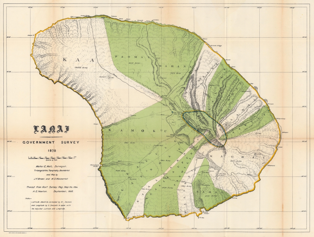

Title
Lanai.
1906 (dated) 20 x 26.5 in (50.8 x 67.31 cm) 1 : 48000
1906 (dated) 20 x 26.5 in (50.8 x 67.31 cm) 1 : 48000
Description
FOR THE ORIGINAL ANTIQUE MAP, WITH HISTORICAL ANALYSIS, CLICK HERE.
Digital Map Information
Geographicus maintains an archive of high-resolution rare map scans. We scan our maps at 300 DPI or higher, with newer images being 600 DPI, (either TIFF or JPEG, depending on when the scan was done) which is most cases in suitable for enlargement and printing.
Delivery
Once you purchase our digital scan service, you will receive a download link via email - usually within seconds. Digital orders are delivered as ZIP files, an industry standard file compression protocol that any computer should be able to unpack. Some of our files are very large, and can take some time to download. Most files are saved into your computer's 'Downloads' folder. All delivery is electronic. No physical product is shipped.
Credit and Scope of Use
You can use your digial image any way you want! Our digital images are unrestricted by copyright and can be used, modified, and published freely. The textual description that accompanies the original antique map is not included in the sale of digital images and remains protected by copyright. That said, we put significant care and effort into scanning and editing these maps, and we’d appreciate a credit when possible. Should you wish to credit us, please use the following credit line:
Courtesy of Geographicus Rare Antique Maps (https://www.geographicus.com).
How Large Can I Print?
In general, at 300 DPI, you should at least be able to double the size of the actual image, more so with our 600 DPI images. So, if the original was 10 x 12 inches, you can print at 20 x 24 inches, without quality loss. If your display requirements can accommodate some loss in image quality, you can make it even larger. That being said, no quality of scan will allow you to blow up at 10 x 12 inch map to wall size without significant quality loss. For more information, it is best consult a printer or reprographics specialist.
Refunds
If the high resolution image you ordered is unavailable, we will fully refund your purchase. Otherwise, digital images scans are a service, not a tangible product, and cannot be returned or refunded once the download link is used.
Cartographer S
Walter Eugene Wall (October 13, 1867 - July 23, 1944) was an American surveyor. Born in Yreka, California, he arrived in Honolulu with his parents in 1880. His father was the architect in charge of the construction of the Iolani Palace. He began working at the Hawaiian Government Survey in 1889 and was appointed Territorial Surveyor General in 1901. He worked for the survey for more than 35 years. Wall attended the Ponahou School where he was known for his athletics, introducing the curveball (referenced as 'curve pitching in baseball' in his obituary) to Hawaii. He married Edith Louise Dietz on June 22, 1903. He died in 1944 in Honolulu. More by this mapmaker...
Andrew B. Graham (1845 - September 9, 1909) was an American lithographer active in Washington, D.C. in late 19th and early 20th century. Graham was born in Washington D.C., the son of a lithographer and engraver. After college, he joined the U.S. Coast Survey, where he was a draftsman until 1889. He retired from the Coast Survey to take over management of his father's lithography firm. The firm, Andrew B. Graham Company, was one of several that thrived on lucrative government publication contracts. Graham died of 'brain fever' in his Washington D. C. residence on September 9 of 1909. Some of his work was republished posthumously until about 1917, and his firm was active until at least the early 1920s. Learn More...
Marcus Douglas Monsarrat (March 29, 1857 - October 23, 1922) was a Hawaiian surveyor. Born in Honolulu, Monsarrat attended Oahu College and graduated in 1873. Monsarrat worked fro the Hawaiian Government Survey from around 1874 until 1877, when he opened his own surveying firm. Over the course of his career, Monsarrat surveyed and mapped a large portion of the Hawaiian Islands and served as crown surveyor from 1878 until Hawaii's annexation by the United States in 1898. He also served as the commissioner of boundaries between the first and second judicial circuits from 1902 until his death. He married Florence Ellen Luce on June 1, 1882, with whom he had three children. He and Florence later divorced. Learn More...
Jacob Foster Brown (July 9, 1854 - January 4, 1925) was an American engineer and surveyor. Born in New Bedford, Massachusetts, Brown arrived in Hawaii at the age of six after his father accepted a job with the Hawaiian government. Brown began working for W. D. Alexander in the late 1860s or early 1870s before attending the Massachusetts Institute of Technology from 1874 - 1877, earning a degree in civil engineering. He served as assistant surveyor-general of Hawaii from 1874 until 1895. In 1885, Brown was appointed to supervise the survey of government lands that would be distributed under the 1884 Homestead Act. He served as land commissioner from November 1895 until May 1901. He married Sarah Emily King on January 18, 1881. Learn More...
Source
Governor of Hawaii Board of Indian Commissioners, 'Report of the Governor of Hawaii', Annual Reports of the Department of the Interior for the Fiscal Year Ended June 30, 1906, (Washington: Government Printing Office) 1907.
References
Moffat, R. M. and G. L. Fitzpatrick, Mapping the Lands and Waters of Hawaii (Honolulu: Editions Limited) 2004 p. 59. OCLC 367573432.