Title
Map of the Malay Peninsula : to accompany the paper of Mr. D.D. Daly...
1882 (dated)
18 x 17 in (45.72 x 43.18 cm)
1 : 1210000
Description
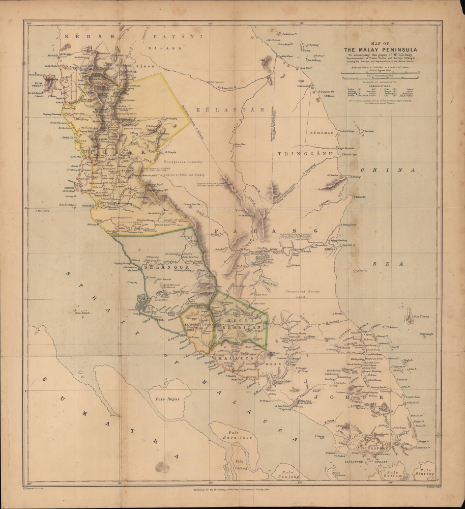
An important map of the Malay Peninsula by Dominic Daniel Daly, lithographed by Edward Weller and published in 1882 in the Proceedings of the Royal Geographical Society. Daly's surveys of portions of the peninsula were the first scientific surveys conducted there. The map depicts the peninsula as British influence over the indigenous sultanates was expanding rapidly, aided by a boom in tin mining.
A Closer Look
Coverage ranges from the southern portions of Kedah and Patani, both quasi-autonomous sultanates under the control of Siam, to the Straits of Malacca, the tip of the Malay Peninsula, and Singapore. Rivers, mountains, and settlements are noted, with greater frequency in areas where the British had a longer presence or proximity. Other areas of the map are blank or noted as unexplored, though certain rivers of the interior of the peninsula are well mapped, particularly the Pahang River and its tributaries. Although the British had charted the coasts of the Malay Peninsula and territories under their direct or indirect control, prior to Daly's surveys the interior was an unknown and foreboding landscape, thought to be filled with near-uninhabitable swamps and jungles. Tin Boom
The British controlled or affiliated territories on the west side of the peninsula were undergoing a rapid transformation at this time as a result of a tin mining boom on par with the gold rushes of the 19th century. Workers from near and far converged on mining regions, often organized by ethnic and native place associations that also facilitated financing and trade for the mines. The rush for riches caused conflict both between and within these communities, which strengthened British claims that they were a necessary overseer and referee of the tin industry. Kuala Lumpur
Among other features, this map is notable for an early reference to Kuala Lumpur ('K. Lumpor') on the Klang River. Resembling gold rush boom towns on other continents, Kuala Lumpur's early history was turbulent, with violence and fires common, and it resembled a miner's camp more than a proper town. The city was effectively ruled by a Guangdong-born Hakka named Yap Ah Loy (葉亞來), known as 'Captain China,' who acted as an intermediary between the Chinese laborers, Malay elite, and British (after Yap's death, the 'Capitan China' title would pass on to others; similar 'Captains' existed for Arab and Indian immigrant communities as well). Kuala Lumpur continued to grow on the back of the tin boom, and by 1880 the British 'Resident' of Selangor had moved there from Klang (where it is still listed here). In 1896, the British established the Federated Malay States and designated Kuala Lumpur as their capital. Political Changes
Other political changes followed, including the reorganization and renaming of territories. 'Province Wellesley' here had been acquired by the East India Company in 1800 to provide food and a defensive buffer zone for Penang, as existed for Dinding to the south. In 1867, Penang, along with Singapore, Malacca, and Dinding, became the Straits Settlements, a crown colony, and the entirety of Province Wellesley was simply renamed Penang. Additionally, borders between territories, including those controlled by Siam, were fixed in the following decades, thanks in part to the surveying work undertaken by Daly.Publication History and Census
This map was drawn by Henry Sharbau, based on surveys by Dominic Daniel Daly, and lithographed by Edward Weller for publication in the Proceedings of the Royal Geographical Society in 1882. It is independently cataloged among the holdings of the University of Chicago Library, while Daly's accompanying article 'Surveys and explorations in the native states of the Malayan Peninsula 1875-82' is cataloged among the holdings of the National Library Board in Singapore and the National Library of Malaysia.
CartographerS
Dominic Daniel Daly (fl. c. 1874 - 1888) was a British surveyor and cartographer active in Australia, the Malay Peninsula, and Borneo in the late 19th century. Scottish by birth, he emigrated to South Australia where his uncle, Sir Dominick Daly, was governor, and worked as a surveyor on the Northern Territory Survey Expedition. Afterwards, he relocated to Singapore and then took up the office of Superintendent of Public Works and Surveys at Selangor. He travelled throughout the British territories as well as the 'native states' of the region. In addition to his surveying work, Daly published articles on the geology and speleology of the Malay Peninsula and Borneo. More by this mapmaker...
Edward Weller (July 1, 1819 - 1884) was a cartographer and engraver based in London. Weller was a nephew of another well-known map publisher Sidney Hall (1788 - 1831), who gave him 50 Pounds to pay his apprenticeship fees. He engraved for many prominent mapmakers and was active enough in the community to be recommended for membership to the Royal Geographical Society in 1851 on the recommendation of John Arrowsmith, among others. He eventually inherited the Sidney Hall map business which led him to follow Arrowsmith as the unofficial geographer to the Royal Geographical Society. Weller was among the first map printers in London to embrace lithography. His best known work appears in Cassell's Weekly Dispatch Atlas, published in monthly segments for subscribers of the 'Weekly Dispatch' newspaper. This collection of maps eventually grew to include much of the known world. Published in various editions from 1855 through the early 1880s. Weller died in May of 1884, leaving behind a successful business and an unhappy widow. His son, Francis Sidney Weller (1849 - 1910), followed in his father's footsteps and continued the family map business. The atlas Mackenzie's Comprehensive Gazetteer of England and Wales was published in 1894 and bore F. S. Weller's signature on the maps. Learn More...
Henry Sharbau, (fl. 1870-1906) was a lithographer active in London and Edinburgh. While nothing is known of his early training, it is likely that his early years were spent with the navy: his earliest known works of the 1870s were on charts produced by the Hydrographic Department. The 1880s saw the beginning of a long association with the Royal Geographic Society, and then with the mapmaking firm of W. and A.K. Johnston. Over a hundred works appear in OCLC with Sharbau’s imprint. Interestingly, the British Naval Lists reveal a Frederic Henry Sharbau (1867-1963!!!) working as a cartographer and draughtsman starting about 1907 and lasting into the 20s. Perhaps this Methuselah is a son? Learn More...
Royal Geographical Society (fl. 1830 - present) is a British Society established in 1830 to promote geographical science and exploration. Originally titled the "Geographical Society of London", the RGS received its royal charter from Queen Victoria in 1859 shortly after absorbing several similar but more regional societies including the African Association, the Raleigh Club and the Palestine Association. The RGS sponsored many of the most important and exciting voyages of exploration ever undertaken, including the exploration of Charles Darwin, David Livingstone, Robert Falcon Scott, Richard F. Burton, John Speke, George Hayward, H. M Stanley, Ernest Shackleton and Sir Edmond Hillary. Today, the RGS remains a leading global sponsor of geographical and scientific studies. The Society is based in Lowther Lodge, South Kensington, London. Learn More...
Source
Daly, D. D., 'Surveys and Explorations in the Native States of the Malayan Peninsula, 1875-82' Proceedings of the Royal Geographical Society and Monthly Record of Geography, Vol. 4, No. 7 (Jul., 1882), pp. 393-412.
Condition
Good. Wear along fold lines. Periodic foxing and other areas of discoloration. Areas of loss at top-right and bottom-right corners. Verso reinforcements with tissue paper on fold lines and along edge. Some pencil annotations.
References
OCLC 173846020, 961906314.