This item has been sold, but you can get on the Waitlist to be notified if another example becomes available, or purchase a digital scan.
1939 Portuguese and Chinese Manuscript Satirical Map of Europe in 1939 (WWII)
MapaHumoristicoDaEuropa-soares-1939$3,625.00

Title
Mapa Humoristico Da Europa - Guerra - 1939 / 歐戰现像
1939 (dated) 18 x 24 in (45.72 x 60.96 cm) 1 : 8190000
1939 (dated) 18 x 24 in (45.72 x 60.96 cm) 1 : 8190000
Description
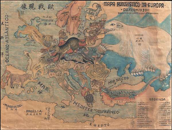
An exceptional zoomorphic satirical map of Europe in 1939, here in manuscript form with all text translated into Chinese. This map is based upon a map drawn by the artist António Soares and published by Livraria Franco just weeks after the October 1939 outbreak of World War II. The map is intended to illustrate the ostensibly neutral Portuguese perspective on the European conflict. Although we do not know who drew this manuscript variant, the added Chinese translations throughout, as well as a key in the lower right, have clearly been added make it accessible to Chinese readers, suggesting a connection with Portuguese Macau.
Produced by a Chinese artist in Macau
This map was almost certainly drawn in East Asia by an East Asian artist, probably in Macau. The Chinese calligraphy is elegant and clearly the work of a practiced hand while the Portuguese text is by contrast clumsy and imitative, even Chinese in character. The colors employed, while somewhat similar to the colors on the printed map, are in tones more common in Asian watercolor than western inks. The wavy ocean here exhibits a delicate nuanced brushstroke, suggestive of Chinese painting, rather than uniform lines evident on the printed version. The misunderstanding of the rhino, used to represent Poland in the printed map, as a water buffalo-like creature on this manuscript variant, also suggests the artist was unfamiliar with rhinos, which at this time were not commonly known in China. Finally, the paper, a thick stock, while not traditional, exhibits characteristics of Asian made western-style papers used by Japanese and Chinese publishers up to and during the war.
Made for neutral state rife with espionage
Portugal at the time was under the leadership of the corporatist authoritarian dictator António de Oliveira Salazar. Salazar was effective in keeping Portugal out of World War II. As a consequence, Portugal, as well as its colonies in the Azores, the Canary Islands, Madeira, and, most significantly here, Macau, became hotbeds of global intrigue and espionage, where the war was expressed via underground trade and cloak-and-dagger manipulations. This map was most likely drawn in Macau, whose neutrality was largely respected by the Japanese throughout the war. Macau became a refugee center during WWII causing its population to climb from about 200,000 to nearly 700,000 people within a few years. Moreover, as the only neutral port in East Asia, it enjoyed a brief economic boom. These combined factors led to considerable local interest in Macau regarding war events and attitudes in Europe.
The print version of this map was issued in 1939 and 1940 by the Lisbon booksellers, Livraria Franco (Livraria Popular de Francisco Franco, 14 Rua Barros Queiroz). The bestiary of zoomorphic iconography is derived from an earlier 1916 map by Soares, Mappa Historico da Europa, published to illustrate World War I. Soares significantly updated the iconography with numerous updates and revisions in the 1939 edition to reflect a changed political climate.
A complex political message
Covering all of Europe, the map is dominated by Russia, which is illustrated, somewhat traditionally, as a threatening polar bear of intimidating bulk. Soares employs historical iconography to represent Spain (a bull), France (a lion rampant), and England (a leopard lunging toward the continent). The lions of France and the leopard of England face off against the tiger of Germany, whose back is turned, seemingly ignorant of threats from further east. Norway and Sweden appear as giraffes, docile in the printed map, but here looking fearfully and defiantly towards Russia. Similarly, the Baltic States, Latvia, Lithuania, and Estonia, as well as Finland, stand firm against the fearsome maw of the Russian bear. Poland, appearing in the printed map as a rhino, is here a vicious jagged-toothed horned water-buffalo bloodied both front and back by Germany and Russia, respectively. Yugoslavia is a ferocious kangaroo carrying a tiny baby kangaroo in its pouch. Italy and Armenia appear as frightening coiled serpents, ready to strike at the underbelly of Europe. Greece is a slow-moving turtle, while Turkey is a fearsome crocodile. It is of note that several southern European countries - Italy, Armenia, Greece, and Turkey - take on a reptilian aspect possibly suggestive of a disassociation with mammalian northern and western Europe. Of the neutral parties, Switzerland is a docile lamb while Portugal, whose perspective this map represents, is a vicious podengo (Portuguese hunting dog).
This is a unique discovery. While the printed Portuguese map is rare, this manuscript map is one a kind and the addition of Chinese text as historical and cultural significance. This map is owned jointly by Boston Rare Maps and Geographicus Rare Antique Maps.
Cartographer
António Soares (September, 1894 – July, 1978) was a Portuguese modernist painter, caricaturist, architect, decorator, and set designer active during the early and middle 20th century. Soares was born in Lisbon and had no formal artistic training. He began his career as an illustrator, producing book covers, posters, caricature maps, and announcements, as well as working with magazines such as Ilustração, Magazine Bertrand and ABC. His work is generally modernist and includes caricature with a focus on worldly themes. Later in his career he began to focus on larger painting, murals, and even architectural decoration. Although little known today, he was well respected in his day. He won the Grand Prix at the Paris International Exposition in 1937, received the Columbano Prize twice at the SPN / SNI Modern Art Exhibitions (1935 and 1948), in 1958 was conferred the rank of officer of the Ordem Militar de Sant'Iago da Espada, and in 1962 received the Diário de Notícias Prize. More by this mapmaker...
Condition
Good. Even toning. Waterstain on the left side. Edge wear, all around. Manuscript.