Digital Image: 1769 Le Rouge/ Crépy Map of Minorca
Minorca-rouge-1759_d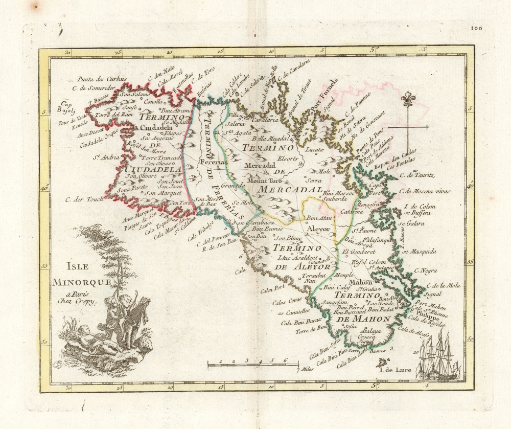

Title
Isle Minorque a paris Chez Crepy.
1759 (undated) 7 x 8.25 in (17.78 x 20.955 cm) 1 : 777777
1759 (undated) 7 x 8.25 in (17.78 x 20.955 cm) 1 : 777777
Description
FOR THE ORIGINAL ANTIQUE MAP, WITH HISTORICAL ANALYSIS, CLICK HERE.
Digital Map Information
Geographicus maintains an archive of high-resolution rare map scans. We scan our maps at 300 DPI or higher, with newer images being 600 DPI, (either TIFF or JPEG, depending on when the scan was done) which is most cases in suitable for enlargement and printing.
Delivery
Once you purchase our digital scan service, you will receive a download link via email - usually within seconds. Digital orders are delivered as ZIP files, an industry standard file compression protocol that any computer should be able to unpack. Some of our files are very large, and can take some time to download. Most files are saved into your computer's 'Downloads' folder. All delivery is electronic. No physical product is shipped.
Credit and Scope of Use
You can use your digial image any way you want! Our digital images are unrestricted by copyright and can be used, modified, and published freely. The textual description that accompanies the original antique map is not included in the sale of digital images and remains protected by copyright. That said, we put significant care and effort into scanning and editing these maps, and we’d appreciate a credit when possible. Should you wish to credit us, please use the following credit line:
Courtesy of Geographicus Rare Antique Maps (https://www.geographicus.com).
How Large Can I Print?
In general, at 300 DPI, you should at least be able to double the size of the actual image, more so with our 600 DPI images. So, if the original was 10 x 12 inches, you can print at 20 x 24 inches, without quality loss. If your display requirements can accommodate some loss in image quality, you can make it even larger. That being said, no quality of scan will allow you to blow up at 10 x 12 inch map to wall size without significant quality loss. For more information, it is best consult a printer or reprographics specialist.
Refunds
If the high resolution image you ordered is unavailable, we will fully refund your purchase. Otherwise, digital images scans are a service, not a tangible product, and cannot be returned or refunded once the download link is used.
Cartographer S
Jean de Beaurain (January 17, 1696 - February 12, 1771) was a French geographer and military historian under Louis XV. He was born in Aix-en-Issart, Pas-de-Calais, and came to Paris in 1715 at age 19, where he studied geography under Pierre Moulart-Sanson (16?? - c. 1721), Géographe du Roi and grandson of Nicolas Sanson (1600 - 1667). Beaurain inherited this same title from Moulart-Sanson in 1721, when he was just 25. He taught geography to Louis XV (1729 - 1765) and received an annual pension of 800 pounds. Beaurain maintained offices on the Quai des Grands-Augustins. He was succeeded by his son, Jean-Baptiste Jacques de Beaurain (1728 - c. 1785). More by this mapmaker...
Georges-Louis Le Rouge (c. 1707 - c. 1790) was a Paris based map publisher operating in the middle part of the 18th century. Le Rouge was born in Hanover Germany as Georg Ludwig, where he was educated and employed as a military engineer and surveyor. His father may have been the French architect Louis Remy de la Fosse (1659 - 1726), which would explain his early education in both engineering and draftsmanship. He assisted his father on a large-scale plan of Darmstadt, which he completed following his father's death in 1726. He may have remained in Darmstadt, but little is known of his life from 1726 - 1736, when he appears in Paris. Le Rouge acquired a position as military and civil engineer for King Louis XV and Louis XVI. Around this time, he Francophied his name to 'Le Rouge'. In 1840, he set up shop on the Rue Des Grands Augustins as an engraver, book publisher, and map publisher. He partnered with the English cartographer and engineer John Rocque (1709 - 1762), who became an important source for English maps, which Le Rouge re-engraved for French use. Despite being born German and adopting Paris as his home, Le Rouge was an ardent Anglophile and spent much of his time translating English books and maps into French. During his active period of roughly forty years Le Rouge produced thousands of maps and diagrams ranging from city and town plans, to atlases, plans of military campaigns and sea charts. He was a friend and correspondent of Benjamin Franklin (1706 - 1790), with whom he produced the important 1769 Franklin/Folger Map of the Gulf Stream. Franklin, who met Le Rouge in Paris, writes that 'He [Le Rouge] is, I believe, a proper person.' He was awarded for his diligence with the impressive but unstipended honorific 'Geographe du Roi'. They may not have served him swell during the French Revolution (1789 - 1799), as his last known work was published in 1789, just before the storming of the Bastille. The exact date of Le Rouge's death remains a mystery. By most estimates, he is believed to have been alive in 1790, but may have lived as long as 1794. Learn More...
Jean-Baptiste Crépy (fl. c. 1730 - 1796), also spelled Creepy, was a French map and print publisher based in Paris during the middle of the 18th century. His father Etienne-Louis Crépy, son of Jean Crépy (1660-1739). Within the family dynasty Jean-Baptiste was known as Crépy le Jeune, or Crépy the Younger. His work ranged from maps, such as his reprint of the Le Rouge issue of the Popple Key Map, to general prints, and even geographically themed board games. He is known to have worked with other French mapmakers o the period including André Basset. maintained offices at Rue St. Jacques a St. Pierre near la Rue de la Parcheminerie. The Crépy firm went into bankruptcy and liquidated at auction on the 24th of April, 1790. Jean-Baptiste Crépy died in 1796. Learn More...
Source
Le Rouge, Georges-Louis /
Crépy, Jean-Baptiste, Atlas Portatif Des Militaires et des Voyageurs..., (Paris: Crépy) 1769.
References
OCLC 1378581211.