This item has been sold, but you can get on the Waitlist to be notified if another example becomes available, or purchase a digital scan.
1769 Le Rouge/ Crépy Map of Minorca
Minorca-rouge-1759$225.00


Title
Isle Minorque a paris Chez Crepy.
1759 (undated) 7 x 8.25 in (17.78 x 20.955 cm) 1 : 777777
1759 (undated) 7 x 8.25 in (17.78 x 20.955 cm) 1 : 777777
Description
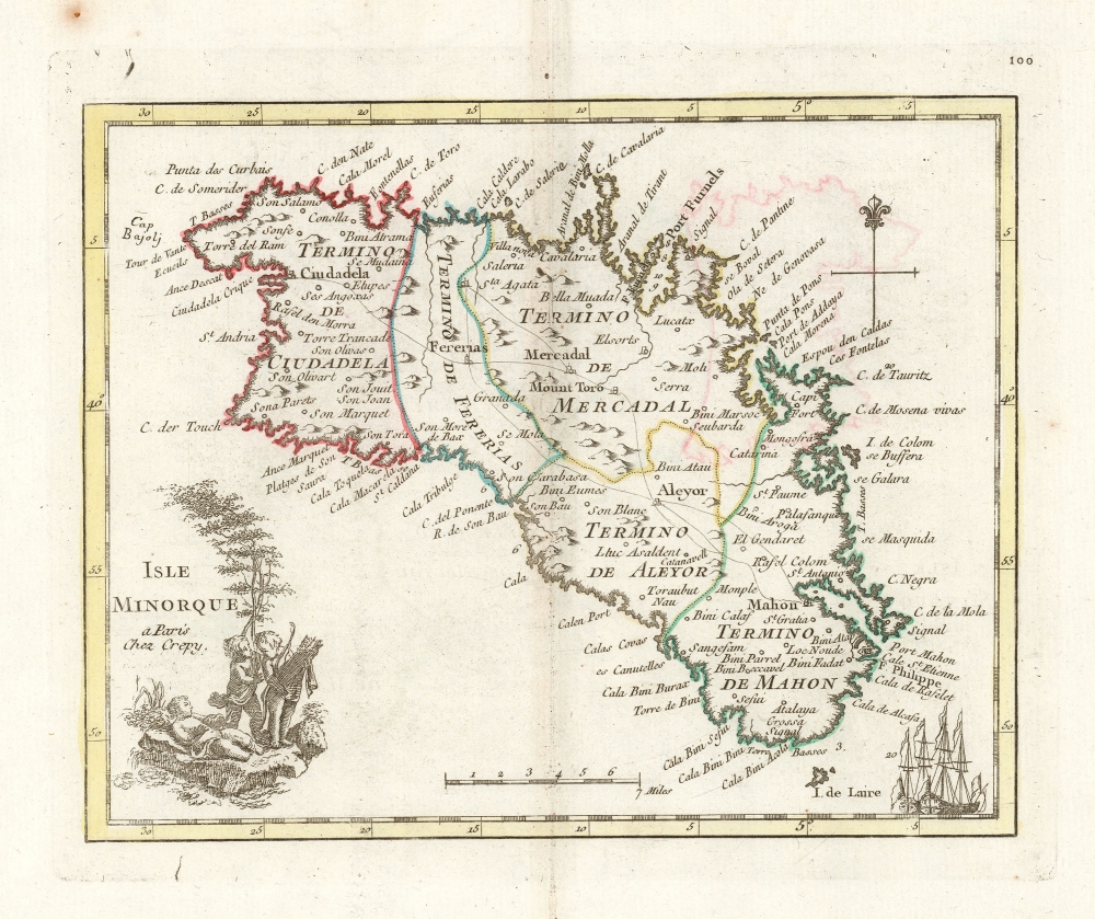
This is a handsome, scarce example of George-Louis Le Rouge's 1759 map of Minorca. It was the last of a hundred maps in his Atlas Nouveau Portatif, which compiled an array of maps relevant to the Seven Years' War's European theatres. Minorca, therefore, was an important inclusion, being the site of the opening naval battle of that war in 1756. The map depicts Minorca and its provincial divisions as they stood during Britain's control of the Island, but the map was produced in the immediate aftermath of the battle by which the French ended British rule in Minorca, taking from Britain her primary Mediterranean base and effectively passing control of that sea to the French.
The maps for Le Rouge's Atlas were mainly sourced from those of Homann and Mayer, and the source for this map was published the year after the Battle of Minorca by Homann Heirs. It had been drawn by the French Royal Geographer, Jean de Beaurain; consequently it presented not only the most recent but the most authoritative mapping of the crucial Mediterranean strongpoint.
The maps for Le Rouge's Atlas were mainly sourced from those of Homann and Mayer, and the source for this map was published the year after the Battle of Minorca by Homann Heirs. It had been drawn by the French Royal Geographer, Jean de Beaurain; consequently it presented not only the most recent but the most authoritative mapping of the crucial Mediterranean strongpoint.
Commentary on the War
The map is attractively engraved: two ships sit side-by-side in the lower right near Port Mahon and a simple compass rose topped with a Fleur de Lis graces the upper right. The cartouche at lower left contains a telling vignette of three putti: one lies on the ground - fatter than the other two, sporting a significant five-o'-clock shadow and scowling angrily, this appears to be an unflattering representation of the British 'John Bull'. Another putto, his eyes on the petulant fallen, is taking away a bundle of bows and arrows while a third follows with concern: the former being France, having just disarmed Britain by taking away Port Mahon; the latter may be a grateful Europe, or a liberated Minorca. (After all, the map is French.)Publication History and Census
This map was engraved for inclusion in Le Rouge's 1759 Atlas Nouveau Portatif. In 1769, the publisher Jean-Baptist Crépy acquired the plates for the book and republished it as Atlas Portatif Des Militaires et des Voyageurs, replacing Le Rouge's imprints throughout whilst leaving the maps themselves unchanged. We see only five examples of the 1769 edition of the Atlas in institutional collections, and only one separate example of the map appearing in a later 1780 edition of the work.CartographerS
Jean de Beaurain (January 17, 1696 - February 12, 1771) was a French geographer and military historian under Louis XV. He was born in Aix-en-Issart, Pas-de-Calais, and came to Paris in 1715 at age 19, where he studied geography under Pierre Moulart-Sanson (16?? - c. 1721), Géographe du Roi and grandson of Nicolas Sanson (1600 - 1667). Beaurain inherited this same title from Moulart-Sanson in 1721, when he was just 25. He taught geography to Louis XV (1729 - 1765) and received an annual pension of 800 pounds. Beaurain maintained offices on the Quai des Grands-Augustins. He was succeeded by his son, Jean-Baptiste Jacques de Beaurain (1728 - c. 1785). More by this mapmaker...
Georges-Louis Le Rouge (c. 1707 - c. 1790) was a Paris based map publisher operating in the middle part of the 18th century. Le Rouge was born in Hanover Germany as Georg Ludwig, where he was educated and employed as a military engineer and surveyor. His father may have been the French architect Louis Remy de la Fosse (1659 - 1726), which would explain his early education in both engineering and draftsmanship. He assisted his father on a large-scale plan of Darmstadt, which he completed following his father's death in 1726. He may have remained in Darmstadt, but little is known of his life from 1726 - 1736, when he appears in Paris. Le Rouge acquired a position as military and civil engineer for King Louis XV and Louis XVI. Around this time, he Francophied his name to 'Le Rouge'. In 1840, he set up shop on the Rue Des Grands Augustins as an engraver, book publisher, and map publisher. He partnered with the English cartographer and engineer John Rocque (1709 - 1762), who became an important source for English maps, which Le Rouge re-engraved for French use. Despite being born German and adopting Paris as his home, Le Rouge was an ardent Anglophile and spent much of his time translating English books and maps into French. During his active period of roughly forty years Le Rouge produced thousands of maps and diagrams ranging from city and town plans, to atlases, plans of military campaigns and sea charts. He was a friend and correspondent of Benjamin Franklin (1706 - 1790), with whom he produced the important 1769 Franklin/Folger Map of the Gulf Stream. Franklin, who met Le Rouge in Paris, writes that 'He [Le Rouge] is, I believe, a proper person.' He was awarded for his diligence with the impressive but unstipended honorific 'Geographe du Roi'. They may not have served him swell during the French Revolution (1789 - 1799), as his last known work was published in 1789, just before the storming of the Bastille. The exact date of Le Rouge's death remains a mystery. By most estimates, he is believed to have been alive in 1790, but may have lived as long as 1794. Learn More...
Jean-Baptiste Crépy (fl. c. 1730 - 1796), also spelled Creepy, was a French map and print publisher based in Paris during the middle of the 18th century. His father Etienne-Louis Crépy, son of Jean Crépy (1660-1739). Within the family dynasty Jean-Baptiste was known as Crépy le Jeune, or Crépy the Younger. His work ranged from maps, such as his reprint of the Le Rouge issue of the Popple Key Map, to general prints, and even geographically themed board games. He is known to have worked with other French mapmakers o the period including André Basset. maintained offices at Rue St. Jacques a St. Pierre near la Rue de la Parcheminerie. The Crépy firm went into bankruptcy and liquidated at auction on the 24th of April, 1790. Jean-Baptiste Crépy died in 1796. Learn More...
Source
Le Rouge, Georges-Louis /
Crépy, Jean-Baptiste, Atlas Portatif Des Militaires et des Voyageurs..., (Paris: Crépy) 1769.
Condition
Very good. Few marginal spots; mended wear at centerfold, some offsetting of original outline color.
References
OCLC 1378581211.