Digital Image: 1795 John Russell Map of New England and Eastern New York
NewEngland-russell-1795_d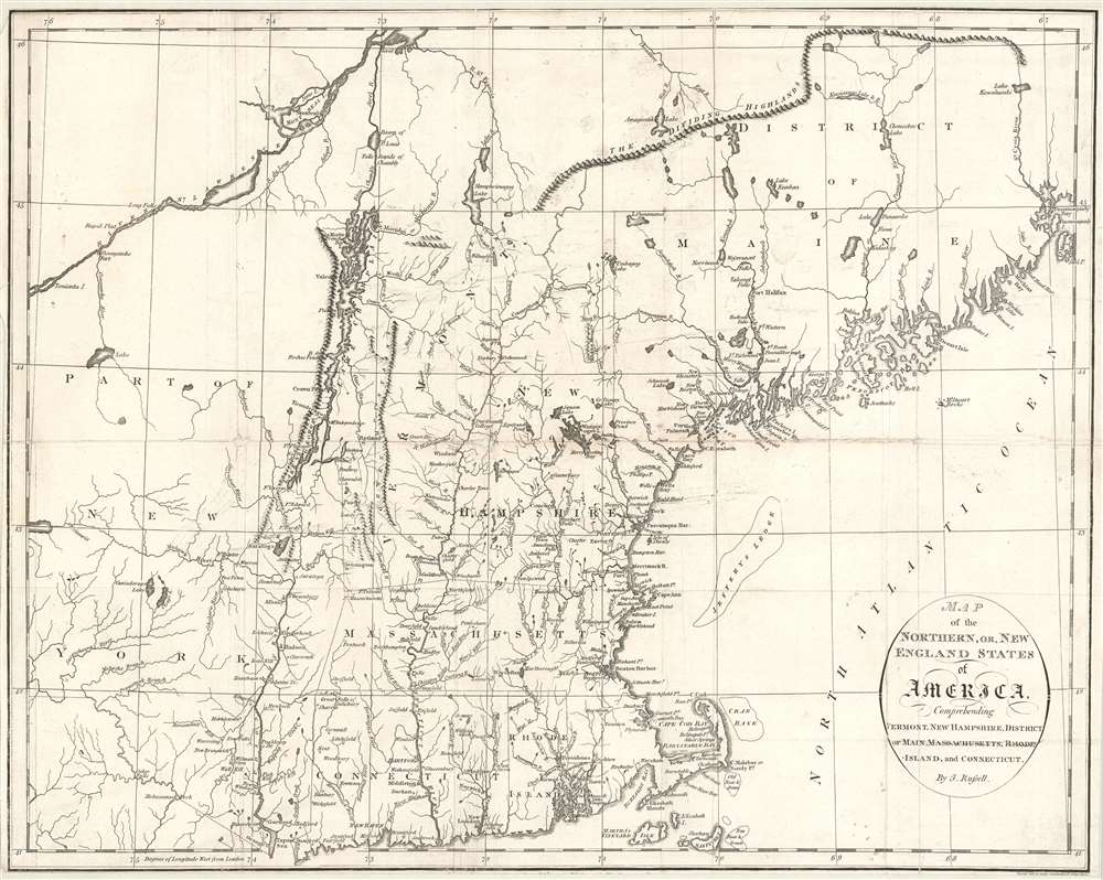

Title
Map of the Northern, or, New England States of America, Comprehending Vermont, New Hampshire, District of Main, Massachusetts, Rhode Island, and Connecticut.
1795 (undated) 14.5 x 18.25 in (36.83 x 46.355 cm) 1 : 1650000
1795 (undated) 14.5 x 18.25 in (36.83 x 46.355 cm) 1 : 1650000
Description
FOR THE ORIGINAL ANTIQUE MAP, WITH HISTORICAL ANALYSIS, CLICK HERE.
Digital Map Information
Geographicus maintains an archive of high-resolution rare map scans. We scan our maps at 300 DPI or higher, with newer images being 600 DPI, (either TIFF or JPEG, depending on when the scan was done) which is most cases in suitable for enlargement and printing.
Delivery
Once you purchase our digital scan service, you will receive a download link via email - usually within seconds. Digital orders are delivered as ZIP files, an industry standard file compression protocol that any computer should be able to unpack. Some of our files are very large, and can take some time to download. Most files are saved into your computer's 'Downloads' folder. All delivery is electronic. No physical product is shipped.
Credit and Scope of Use
You can use your digial image any way you want! Our digital images are unrestricted by copyright and can be used, modified, and published freely. The textual description that accompanies the original antique map is not included in the sale of digital images and remains protected by copyright. That said, we put significant care and effort into scanning and editing these maps, and we’d appreciate a credit when possible. Should you wish to credit us, please use the following credit line:
Courtesy of Geographicus Rare Antique Maps (https://www.geographicus.com).
How Large Can I Print?
In general, at 300 DPI, you should at least be able to double the size of the actual image, more so with our 600 DPI images. So, if the original was 10 x 12 inches, you can print at 20 x 24 inches, without quality loss. If your display requirements can accommodate some loss in image quality, you can make it even larger. That being said, no quality of scan will allow you to blow up at 10 x 12 inch map to wall size without significant quality loss. For more information, it is best consult a printer or reprographics specialist.
Refunds
If the high resolution image you ordered is unavailable, we will fully refund your purchase. Otherwise, digital images scans are a service, not a tangible product, and cannot be returned or refunded once the download link is used.
Cartographer S
John Russell (c. 1750 - 1829) was a British cartographer active in London during the late 18th and early 19th centuries. Russell apprenticed as a goldsmith under William Palmer before turning to engraving and printing. He drew maps and engraved for several major publishers of his period including Alexander Dalrymple, Benjamin Henry, Robert Sayer, John Moore, and William Guthrie. Russell's 10 apprentices included such prominent cartographers as Alexander Findlay and Samuel Clapp. Russell was based on Constitution Row Grays Inn Lane, Middlesex (London). More by this mapmaker...
Henry Delahoy Symonds (fl. 1791 - 1816) was a British publisher / printer. He was an active and considerable bookseller for many years in Paternoster Row. As stated in an obituary, 'in the commencement of the crusade against the French Revolution, he suffered four years imprisonment in Newgate, and paid a heavy fine for vending some political pamphlets.' Learn More...
Source
Russell, John, An American Atlas (London), 1795.
References
Boston Public Library, Leventhal, Map 60.2.N3 1795. McCorkle, B. B, New England in Early Printed Maps 1513 - 1800, #795.9. Phillips (Maps) p. 472.