This item has been sold, but you can get on the Waitlist to be notified if another example becomes available, or purchase a digital scan.
1795 John Russell Map of New England and Eastern New York
NewEngland-russell-1795$200.00

Title
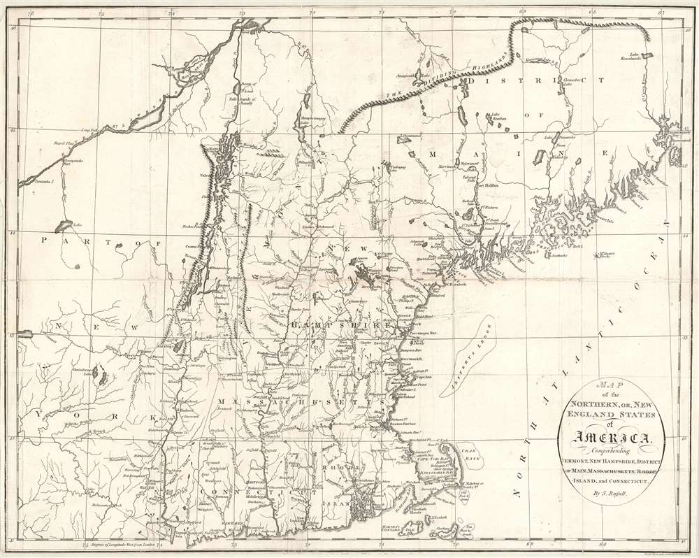
Map of the Northern, or, New England States of America, Comprehending Vermont, New Hampshire, District of Main, Massachusetts, Rhode Island, and Connecticut.
1795 (undated) 14.5 x 18.25 in (36.83 x 46.355 cm) 1 : 1650000
1795 (undated) 14.5 x 18.25 in (36.83 x 46.355 cm) 1 : 1650000
Description
An attractive and finely engraved 1795 map of New England by John Russell - one of the few commercial maps of New England issued immediately following the American Revolutionary War (1775 - 1783). The map covers the northwestern part of the United States from, roughly, Lake Oneida (near Fort Stanwix) to Passamaquoddy Bay, New Brunswick, and from Montreal south as far as Tappan Zee, Martha's Vineyard, and Nantucket. This includes the District of Maine (which was then under the governance of Massachusetts), Vermont, New Hampshire, Massachusetts, Connecticut, and Eastern New York.
Publication History and Census
This map was engraved by John Russell at Constitution Row Grays Inn Lane, Middlesex (London), England. It was published by Henry Delahoy Symonds at no. 20 Paternoster Row, London, and appeared in Russell's 1795 An American Atlas, the geographical component of William Winterboham's Historical, Geographical, Commercial and Philosophical View of the United States. This work was followed by an American edition published by John Reid in 1796. Separate examples of Russell's maps are increasingly uncommon on the market.CartographerS
John Russell (c. 1750 - 1829) was a British cartographer active in London during the late 18th and early 19th centuries. Russell apprenticed as a goldsmith under William Palmer before turning to engraving and printing. He drew maps and engraved for several major publishers of his period including Alexander Dalrymple, Benjamin Henry, Robert Sayer, John Moore, and William Guthrie. Russell's 10 apprentices included such prominent cartographers as Alexander Findlay and Samuel Clapp. Russell was based on Constitution Row Grays Inn Lane, Middlesex (London). More by this mapmaker...
Henry Delahoy Symonds (fl. 1791 - 1816) was a British publisher / printer. He was an active and considerable bookseller for many years in Paternoster Row. As stated in an obituary, 'in the commencement of the crusade against the French Revolution, he suffered four years imprisonment in Newgate, and paid a heavy fine for vending some political pamphlets.' Learn More...
Source
Russell, John, An American Atlas (London), 1795.
Condition
Average. Map has been re-margined on all sides and laid down on pH neutral paper. Several splits, repaired and reinforced - as seen here. Priced accordingly.
References
Boston Public Library, Leventhal, Map 60.2.N3 1795. McCorkle, B. B, New England in Early Printed Maps 1513 - 1800, #795.9. Phillips (Maps) p. 472.