Digital Image: 1773 Staehlin Speculative Map of the North Pacific
NouvelleCarteDecouvertes-staehlin-1773_d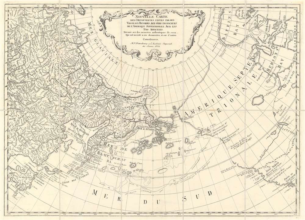

Title
Nouvelle Carte des Decouvertes Faites par des Vaisseaux Russiens aux Cotes Inconnues de l'Amerique Septentrionale avec les Pais Adiacents. Dressée sur des memoires authentiques de ceux Qui ont assisté a ces decouverts, et sur d'autres Connoissances.
1773 (dated) 19 x 26.5 in (48.26 x 67.31 cm) 1 : 20000000
1773 (dated) 19 x 26.5 in (48.26 x 67.31 cm) 1 : 20000000
Description
FOR THE ORIGINAL ANTIQUE MAP, WITH HISTORICAL ANALYSIS, CLICK HERE.
Digital Map Information
Geographicus maintains an archive of high-resolution rare map scans. We scan our maps at 300 DPI or higher, with newer images being 600 DPI, (either TIFF or JPEG, depending on when the scan was done) which is most cases in suitable for enlargement and printing.
Delivery
Once you purchase our digital scan service, you will receive a download link via email - usually within seconds. Digital orders are delivered as ZIP files, an industry standard file compression protocol that any computer should be able to unpack. Some of our files are very large, and can take some time to download. Most files are saved into your computer's 'Downloads' folder. All delivery is electronic. No physical product is shipped.
Credit and Scope of Use
You can use your digial image any way you want! Our digital images are unrestricted by copyright and can be used, modified, and published freely. The textual description that accompanies the original antique map is not included in the sale of digital images and remains protected by copyright. That said, we put significant care and effort into scanning and editing these maps, and we’d appreciate a credit when possible. Should you wish to credit us, please use the following credit line:
Courtesy of Geographicus Rare Antique Maps (https://www.geographicus.com).
How Large Can I Print?
In general, at 300 DPI, you should at least be able to double the size of the actual image, more so with our 600 DPI images. So, if the original was 10 x 12 inches, you can print at 20 x 24 inches, without quality loss. If your display requirements can accommodate some loss in image quality, you can make it even larger. That being said, no quality of scan will allow you to blow up at 10 x 12 inch map to wall size without significant quality loss. For more information, it is best consult a printer or reprographics specialist.
Refunds
If the high resolution image you ordered is unavailable, we will fully refund your purchase. Otherwise, digital images scans are a service, not a tangible product, and cannot be returned or refunded once the download link is used.
Cartographer
Jacob von Staehlin (May 9, 1709 - June 25, 1785) was a German-Russian polymath known as an engraver, cartographer, memoirist, full state councilor, and member of the Russian Academy of Sciences. Born in Memmingen, Upper Swwabia, von Staehlin attended the University of Leipzig and, in 1735, was called to St. Petersburg to work for the St. Petersburg Academy. He became a member of the Academy and a professor of 'eloquence and poetry' in 1738 and in 1741 took over the Department of Art at the Academy. He was appointed teacher to the heir to the Russian throne, Peter Fedorovich, in 1742, and after his wedding was named his personal librarian. Staehlin helped with the creation of the First Atlas of the Russian Empire, which was published in 1745. The art department was changed into the Academy of Fine Arts in 1747, and Staehlin was was entrusted with its management, and even developed drawing and engraving programs. Staehlin died in St. Petersburg in 1785. More by this mapmaker...
References
John Carter Brown Library Cabinet Cl773 / 1.