Digital Image: 1927 Ilonka Karasz Pictorial Map of Paris, France
Paris-ilonkakarasz-1927_d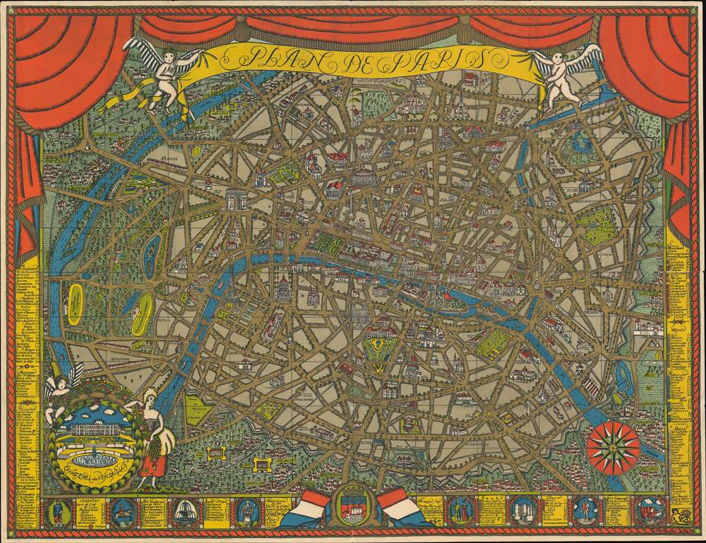

Title
Plan de Paris.
1927 (dated) 28 x 26.25 in (71.12 x 66.675 cm)
1927 (dated) 28 x 26.25 in (71.12 x 66.675 cm)
Description
FOR THE ORIGINAL ANTIQUE MAP, WITH HISTORICAL ANALYSIS, CLICK HERE.
Digital Map Information
Geographicus maintains an archive of high-resolution rare map scans. We scan our maps at 300 DPI or higher, with newer images being 600 DPI, (either TIFF or JPEG, depending on when the scan was done) which is most cases in suitable for enlargement and printing.
Delivery
Once you purchase our digital scan service, you will receive a download link via email - usually within seconds. Digital orders are delivered as ZIP files, an industry standard file compression protocol that any computer should be able to unpack. Some of our files are very large, and can take some time to download. Most files are saved into your computer's 'Downloads' folder. All delivery is electronic. No physical product is shipped.
Credit and Scope of Use
You can use your digial image any way you want! Our digital images are unrestricted by copyright and can be used, modified, and published freely. The textual description that accompanies the original antique map is not included in the sale of digital images and remains protected by copyright. That said, we put significant care and effort into scanning and editing these maps, and we’d appreciate a credit when possible. Should you wish to credit us, please use the following credit line:
Courtesy of Geographicus Rare Antique Maps (https://www.geographicus.com).
How Large Can I Print?
In general, at 300 DPI, you should at least be able to double the size of the actual image, more so with our 600 DPI images. So, if the original was 10 x 12 inches, you can print at 20 x 24 inches, without quality loss. If your display requirements can accommodate some loss in image quality, you can make it even larger. That being said, no quality of scan will allow you to blow up at 10 x 12 inch map to wall size without significant quality loss. For more information, it is best consult a printer or reprographics specialist.
Refunds
If the high resolution image you ordered is unavailable, we will fully refund your purchase. Otherwise, digital images scans are a service, not a tangible product, and cannot be returned or refunded once the download link is used.
Cartographer
Ilonka Karasz (July 13, 1896 – May 26, 1981) was a Hungarian-American cartographer, industrial designer, and illustrator active in New York in the early to mid-20th century. Karasz was born in Budapest, Hungary. She was one of the first women admitted to the Royal Academy of Arts and Crafts. She emigrated to the United States in 1913, when she was seventeen, establishing herself as an artist in Greenwich Village. In 1914, Karasz partnered with Winold Reiss (1886 - 1853) to found the European-American artists' collective Society of Modern Art. Shortly after it was founded in 1915, she took a position teaching textile design at the Modern Art School. Karasz was exceptionally versatile, producing textiles, wallpaper, wrapping paper, furniture, nurseries, tea sets, china plates, maps, and book jackets. She is perhaps best known for her cover-art contracts for the New Yorker from 1924 to 1973. Although not known as a cartographer, Karasz incorporated maps into various aspects of her work, from book cover design to wallpaper. Her largest map is a 1927 pictorial map of Paris. Several of her New Yorker covers are also cartographic in nature. Karasz died at her daughter's home in Warwick, New York, seven weeks before her 85th birthday. Her work was subsequently subject to several gallery shows and retrospectives. More by this mapmaker...
References
OCLC 41908376. Rumsey 8091.000.