1683 Cantelli da Vignola Map of Southeast Asia: Malay, Singapore, Thailand
PenisoladellIndia-cantellidavignola-1683-2$2,000.00

Title
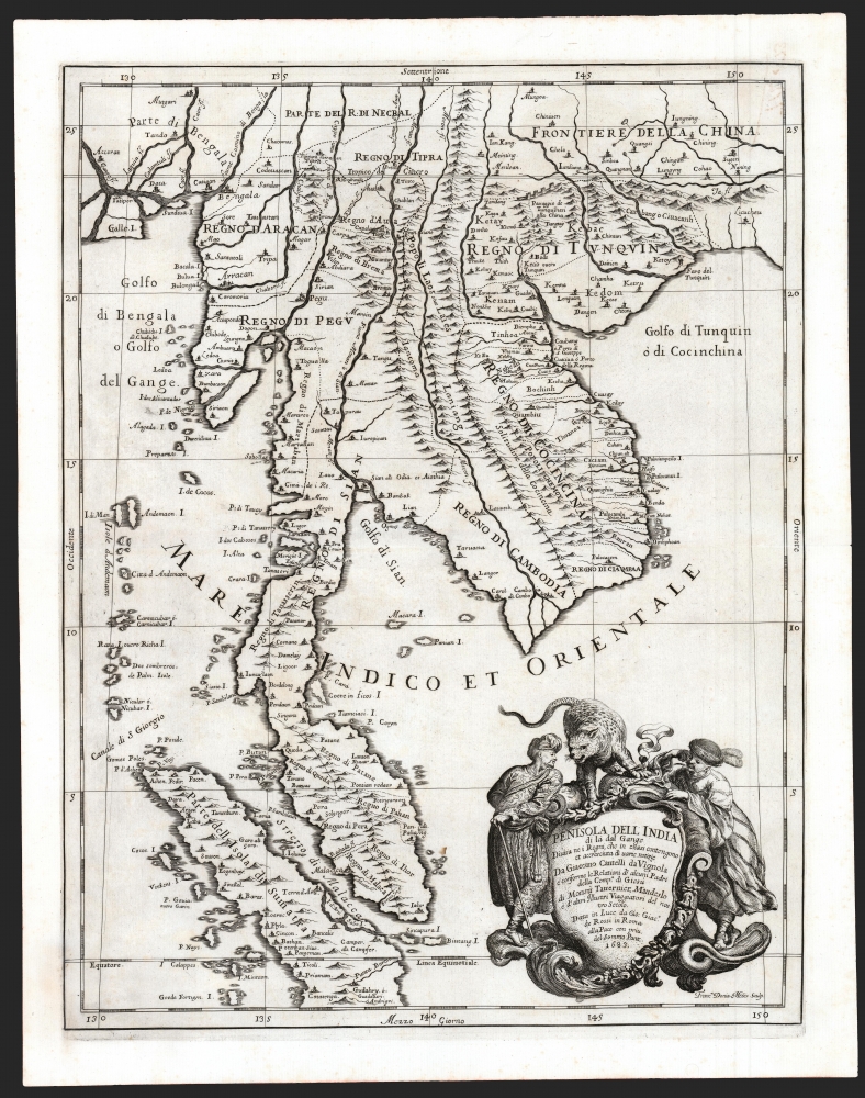
Penisola Dell India di la dal Gange Diusa ne i Regni, che in essasi contengono et accresciuta di varie notizie. Da Giacomo Cantelli da Vignola e conforme le Relationi di alcuni Padri della Compa di Giesu di Monsu Tavernier, Mandeslo e d`altri Illustri Viaggiatori del nostro Secolo . . . 1683.
1683 (dated) 21 x 16.25 in (53.34 x 41.275 cm) 1 : 6150000
1683 (dated) 21 x 16.25 in (53.34 x 41.275 cm) 1 : 6150000
Description
A superb example of Giacomo Cantelli da Vignola's scarce, beautiful, and cartographically significant 1683 map of Southeast Asia. This is one of the first maps of Southeast Asia to incorporate independent polities in Malay based on new information from Johan Albrecht de Mandelslo, and to incorporate contemporaneous French travelers' reports of Vietnam. Centered on modern-day Bangkok (named, as is the capital at Ayyuthaya), the map embraces much of modern-day Thailand, all of Malaysia, Laos, Cambodia, and Vietnam, and parts of Burma, China, and Sumatra. Singapore is shown as an island. A large and dramatic cartouche demands attention in the lower right and features two Southeast Asian potentates in postures indicating no discomfiture whatever with the snarling leopard surmounting the cartouche.
Cartographic History
The broad form of the map is at least in part derived from Dutch charts of this region. Some of the details go as far back as Jan Huygen van Linschoten's (1563 - 1611) purloined Portuguese charts. These early sources have been amended by more recent information. Some is drawn from Melchizidek Thevenot's 1663 chart of Southeast Asia. (For example, the incorrect placement of the Cocos (Keeling) islands at the northwest end of Sumatra.)Politics Between the Ganges and the Mekong
It is the delineation of regional polities that sets this map apart from any earlier work: from modern Burma to the southeastern limit of China, extending down though Cochinchina, Thailand and the Malay Peninsula, provincial boundaries are marked by dotted lines. West of the Mekong, these are derived from the report of German adventurer Johan Albrecht de Mandelslo (1616 - 1644), whose 1638 travels in the Far East were included in Adam Olearius' 1647 account of Holstien's embassy to Muscovy and Persia. Mandeslo produced no map of his own, and there are only a handful of maps drawing from his narrative. This is the only one of which we are aware applying his information to the lands beyond the Ganges.All Rhodes Lead To…
East of the Mekong, Cantelli's map draws from a different source. In the cartouche, Cantelli announced that his map was drawn 'according to the reports of some Fathers of the Society of Jesu, of Messieurs Tavernier, Mandelslo, and other illustrious travelers of our century'. Consequently, it has been assumed that Cantelli's source for the details pertaining to Vietnam on this map come from the reports and the map of the elder Tavernier, Daniel (1610 - 1648). A cursory comparison of the present map with Tavernier's 1679 map of Tonkin and southern China (published by his younger brother, Jean-Baptiste) is enough to cast doubt on this assertion. Cantelli's source for this region, in terms of its topography, toponymy, and boundaries, is far more likely to be the 1653 map of the Jesuit Father Alexandre de Rhodes (1593 - 1660). A quick glance at the islands off the southern Vietnamese coast, the names of the provinces, even the names of the cities, is enough to discard Tavernier's map in favor of the Rhodes as source for Cantelli's Vietnam. Jean-Baptiste Tavernier's descriptions of his travels do appear to inform some of this map. For example, the kingdom of Tipra, between Pegu and China, appears in his travels but not in Mandelslo's. But it may well be that the illustrious Tavernier's name may have been of more value to Cantelli than his geographical information.A Tipping Point
This map appeared at a time in which European knowledge and interest in this region, and in particular the Kingdom of Siam, was reaching a peak. Unfortunately, the travelers' information about these lands that was available was, at best, peripheral: Tavernier's interests were more related to the Mogul Empire and China; Mandelslo's focus had been Persia, until his pursuit by the family of a man he had killed there prompted him to hasten further east. In 1685, King Louis XIV of France set his ambassador Alexandre de Chaumont (1640 - 1710) to Siam, a journey which would lead to a revolution in the mapping of the region and an explosion of fresh information about Siam in particular, and Southeast Asia in general, but which also led to Siam being closed to foreigners for the subsequent 150 years, ending further cartographic advancement.Publication History and Census
This map was prepared in 1683 by Giacomo Cantelli da Vignola, engraved by Franciscus Donia-Messis, and published by Giacomo de Rossi in his 1692 Mercurio Geografico. We note four examples cataloged in OCLC which are part of the collections at Harvard University, the Biblioteca Nacional de España, the Bibliothèque nationale de France, and the National Library of Australia.CartographerS
Giacomo Cantelli da Vignola (February 22, 1643 - November 30, 1695) was an important Italian cartographer and engraver active in 17th century Italy. Cantelli was born in Montorsello, near Vignola, Italy to a prominent local family. After studying literature at the University of Bologna, Cantelli took a position as secretary to the Marquis Obizzi de Ferrara. Eventually Cantelli relocated to Venice where he developed an interest in cartography. He later traveled to Paris in the company of the French ambassador where became acquainted with the French cartographer Guillaume Sanson, as well as his contemporaries Jacques-Andre Duval and Michel-Antoin Baudrand. It was most likely the influence of these innovative French cartographers that inspired Cantelli's careful and meticulous approach, in which he based his cartography not just on earlier maps, but also very much in the French style upon accounts written by travelers and merchants regarding actual travel to foreign lands. Back in Italy, Cantelli took service with Count Rinieri Marescotti, with whom he traveled extensively throughout Italy, becoming in the process acquainted with the Italian publisher Giovanni Giacomo de Rossi. It is with Rossi that Cantelli began officially publishing his maps. The earliest maps to bear the Cantelli-Rossi imprint date to 1672 and detail the Holy Land, Persia, and the Ottoman Empire. Around 1680 the duo also began to publish the Mercurio Geografico, a large format atlas illustrating all parts of the world in a splendid Italian baroque detail defined by elaborate finely engraved cartouche work, high quality paper, bold Roman lettering, and dark rich inks. Some have compared his style go that of Giovanni Antonio Magini, another Italian cartographer of the previous generation. Cantelli da Vignola in fact pioneered the Italian style of fine bold engraving that would eventually be embraced and expanded upon by Vincenzo Coronelli. His work drew the attention of Pope Innocent XI and Reggio Francesco II d'Este, the Duke of Modena, both of whom offered him a position as court geographer. Cantelli chose to work with the Duke of Modena, in the service of whom he produced numerous maps and well as two large globes. He died in Modena in November 1695. More by this mapmaker...
Giovanni Giacomo de Rossi (1627 - 1691) was an Italian engraver and printer, active in Rome during the second half of the 17th century. His father, Giuseppe de Rossi (1570 - 1639), was the founder of the most important and active printing press of the 17th century in Rome. The printing press was begun in 1633, by Giuseppe de Rossi, and it passed firstly to Giovanni Giacomo and to his brother Giandomenico (1619 - 1653), and then later to Lorenzo Filippo (1682-?), then Domenico de Rossi (1659 - 1730). Giovanni Giacomo de Rossi was most active between 1638 and 1691 and was to take the company to the height of its success. The artists that he printed the etchings for included Giovanni Benedetto Castiglione (1609 - 1665), Pietro Testa (1612-1650), and Giovan Francesco Grimaldi (1606 – 1680). Cartographically he is best known for producing the maps of Giacomo Cantelli da Vignola and publishing them in his c. 1683 Mercurio Geografico. In 1738 the firm became the Calcografia Camerale, from 1870 until 1945 the Regia Calcografica, and today it is known as the Calcografia Nazionale. The Calcografia Nazionale holds is one of the finest collections of early printing plates and prints in the world. Learn More...
Alexander de Rhodes (March 15, 1593 - November 5, 1660) was a French Jesuit father, mapmaker, historian, and lexicographer active in Vietnam in the early 17th century. It is believed that he may have been of Jewish descent. Rhodes was born in Avignon, France and took Jesuit vows in 1612. He sailed to Macau in 1623 with the intention of joining a mission in Japan. When the Shogun banned missionary activity, Rhodes was redirected to a growing Jesuit mission in Hoi An, near present day Danang, then part of the Champa Kingdom, Chochinchina. Rhodes stated at the mission in Chochinchina mission from December 1624 to July 1627). The Champa Kingdom (Chiampa) in south central Vietnam, and the Tonkin Kingdom around Hanoi, were then at war and travel between the two kingdoms impossible - in fact there was a wall. Rhodes then set sail northward, traveling all the way to Macao, before turning south to the largely unknown Kingdom of Tonkin. There he established the first Jesuit mission in Tonkin. He remained in Tonkin in March 1627. He became one of the first Europeans to become proficient in Vietnamese. In July 1630, the Viet king, Trịnh Trán, accused him of spying for the Nguyễn of the Champa Kingdom and exiled him from Tonkin. More likely his Christian teachings were taking hold in court and threatening the polygamas values of Vietnam. Taking refuge in the regional Jesuit center in Macao, where he composed a history of Chochinchina. When political tensions lessened in 1640, he returned to Tonkin, traveling throughout the country, often in disguise. Rhodes left Vietnam for the last time in 1645, returning to Rome in 1649. Rhodes published two maps, a tiny map measuring 12 x 18 cm for his 1650 history of Tonkin, and in partnership with Pierre Mariette, a much larger and more detailed map published for his 1653 Divers voyages et missions du P. Alexandre de Rhodes. This second map is considered the first significant published European map of Tonkin. Later in life, Rhodes helped to found the Paris Foreign Missions Society in 1659. As neither the Portuguese nor the Pope showed interest in the project, Alexandre de Rhodes, with Pope Alexander VII's agreement, found secular volunteers in Paris in the persons of François Pallu and Pierre Lambert de la Motte, the first members of the Paris Foreign Missions Society, who were sent to the Far-East as Apostolic vicars. Rhodes was sent on a final missionary voyage, to Persia. He died in Isfahan in 1660 and was buried in the New Julfa Armenian Cemetery. Learn More...
Source
Rossi, G., Mercurio geografico overo guida geographica in tutte le partie del Modo, (Rome) 1692.
Condition
Fine. Generous margins and a bold strike.
References
Shirley, R., Maps in the atlases of the British Library, T.ROSS-1e, #180. OCLC 495092971, 224328437. Durand, F., Maps of Malaya and Borneo: Discovery, Statehood and Progress, p. 112, plate no 37. Suárez, T., Early Mapping of Southeast Asia, p. 212-213.