1817 Thomson Map of Persia and Afghanistan
Persia-thomson-1817-2$300.00

Title
Persia.
1817 (dated) 20.5 x 25 in (52.07 x 63.5 cm) 1 : 5500000
1817 (dated) 20.5 x 25 in (52.07 x 63.5 cm) 1 : 5500000
Description
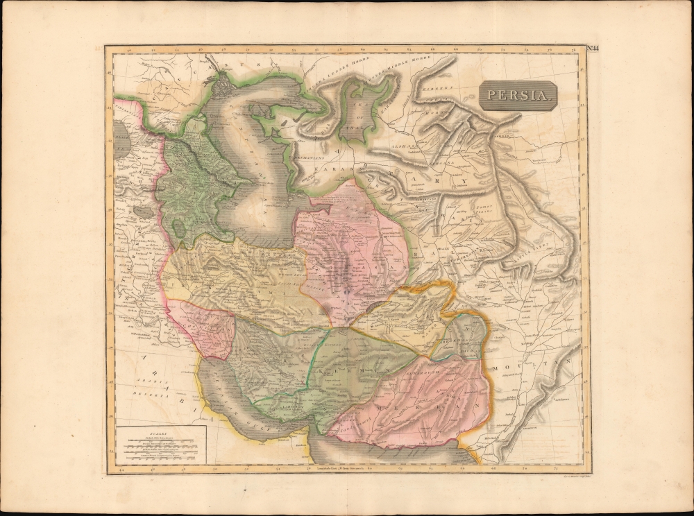
This is an 1817 map of Qujar Persia, including modern-day Afghanistan, by Edinburgh cartographer John Thomson. The map is notable for its naming of multiple emirates and kingdoms on the western shore of the Persian Gulf - including Qatar, Dubai, Kuwait, and Bahrain.
A Closer Look
The map details the Persian Empire under the powerful Qajar Dynasty. Coverage extends from Georgia and the Caspian Sea eastward past modern-day Afghanistan and Pakistan as far as India. Towns, rivers, mountains, islands, and various other important topographical details are noted. Tehran (Taheran) appears just south of the Caspian.Persian Gulf
The map loosely follows the French nautical chart maker D'Après de Mannevillette (1707 - 1780) in its outline of the western shores of the Persian Gulf - but significant detail has been added. The island of Bahrein is recognizable. Grane, just to the north refers to Kuwait. The map shows Dubai Creek extending inland, its mouth is marked as 'Seer', a reference to the al Fahidi Fort, constructed in 1787.Missing Peninsula of Qatar
Qatar is identified as 'Catura', but it's peninsular form is not in evidence. This is not an isolated error. European navigators did not visit the western gulf due to an abundance of coral reefs blocking access for deep-draft ocean-going ships. Instead, they received reconnaissance from local nakhudas (skippers) who freely navigated the area in shallow-draft dhows and maintained an oral navigational tradition. Without modern navigational equipment, identifying Qatar as a peninsula was difficult even to those who regularly navigated the region.Publication History and Census
This map was prepared and engraved in 1814 in Edinburgh by J. and G. Menzies for inclusion in the 1817 first edition of John Thomson's New General Atlas.CartographerS
John Thomson (1777 - c. 1841) was a Scottish cartographer, publisher, and bookbinder active in Edinburgh during the early part of the 19th century. Thomson apprenticed under Edinburgh bookbinder Robert Alison. After his apprenticeship, he briefly went into business with Abraham Thomson. Later, the two parted ways, John Thomson segueing into maps and Abraham Thomson taking over the bookbinding portion of the business. Thomson is generally one of the leading publishers in the Edinburgh school of cartography, which flourished from roughly 1800 to 1830. Thomson and his contemporaries (Pinkerton and Cary) redefined European cartography by abandoning typical 18th-century decorative elements such as elaborate title cartouches and fantastic beasts in favor of detail and accuracy. Thomson's principle works include Thomson's New General Atlas, published from 1814 to 1821, the New Classical and Historical Atlas of 1829, and his 1830 Atlas of Scotland. The Atlas of Scotland, a work of groundbreaking detail and dedication, would eventually bankrupt the Thomson firm in 1830, at which time their plates were sequestered by the court. The firm partially recovered in the subsequent year, allowing Thomson to reclaim his printing plates in 1831, but filed again for bankruptcy in 1835, at which time most of his printing plates were sold to A. K. Johnston and Company. There is some suggestion that he continued to work as a bookbinder until 1841. Today, Thomson maps are becoming increasingly rare as they are highly admired for their impressive size, vivid hand coloration, and superb detail. More by this mapmaker...
John Menzies (October 27, 1772 - October 16, 1857) was a Scottish engraver active in Edinburgh during the late 18th and early 19th centuries. Menzies mastered engraving as an apprentice to James Rymer. In 1811, he partnered with his younger brother, George Menzies, to found the engraving firm of J. and G. Menzies, which was active until about 1831. Later his son, also named John, joined the firm and they engraved jointly under the imprint of J. Menzies and Son. At its height, the Menzies firm employed three men and three apprentices. Menzies engraved maps for Thomas Brown and John Thomson, among others. After his death, his son, John Menzies II (1819 – 1891), continued the family business until about 1891. Learn More...
Baldwin and Cradock (fl. c. 1810 - 1860) were London based publishers working in the early to mid 19th century. They are best known for their publication of the Society for the Diffusion of Useful Knowledge's ground breaking subscription atlas. They also published John Thomson's magnificent New General Atlas from 1814 - c. 1820. In addition to their cartographic corpus, the firm had wide ranging publishing interests in many other areas, including books, broadsides, and an investment in Blackwoods Magazine. They had their offices at 47 Paternoster Row, London, England. This firm also published under the imprint Baldwin, Cradock, and Joy and Cradock and Joy. Learn More...
Source
Thomson, J., A New General Atlas, (Edinburgh: Baldwin, Cradock, Joy) 1817.
Thomson's New General Atlas was first published in 1817 and continued to be published until about 1821. This is the first of Thomson's major cartographic works and the atlas for which is most celebrated. The New General Atlas follows in the Edinburgh School, which eschews excessive decoration in favor of a more minimalistic fact-based cartographic vision, as established by John Pinkerton, Laurie and Whittle, John Cary, and others in the previous decades. The maps are notable for their massive scale, heavy stock, elegant color work, and easy-to-read typefaces. Although the atlas stopped being published after 1821, Thomson continued to offer 'supplementary' maps that could be tipped into the atlas as late as 1830, when he declared bankruptcy. The maps in the Thomson Atlas were engraved by Thomas Clerk, William Dassauville, Nathaniel Rogers Hewitt, James Kirkwood, Robert Kirkwood, John Menzies, George Menzies, Edward Mitchell, John Moffatt, Samuel John Neele, Robert Scott, and James Wyld.
Condition
Very good. Minor wear along original centerfold. Original platemark. Some transference.
References
Rumsey 1007.000 Phillips (Atlases) 731. Newberry Library: Ayer +135 T4 1817.