1827 Carey and Lea Map of Peru, German Edition
PeruGerman-careylea-1827$550.00

Title
Peru.
1827 (dated) 18 x 20.5 in (45.72 x 52.07 cm) 1 : 6336000
1827 (dated) 18 x 20.5 in (45.72 x 52.07 cm) 1 : 6336000
Description
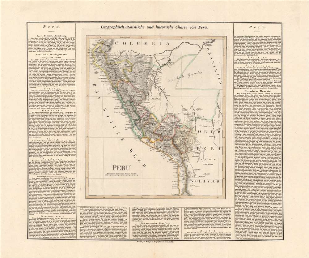
This is an 1827 German edition of Matthew Carey and Isaac Lea's map of Peru, published in Weimar by the Geographischen Instituts. It is an early map, among the first in German, of Peru following its independence, which had only been secured the previous year.
Although based on the sheet of Peru in Carey and Lea's American Atlas, this is not an exact, one-to-one transposition of text from the English edition. In some places, the text very neatly matches, while elsewhere information is combined, condensed, or arranged differently (such as the population statistics at left, which appear as a table in the American Atlas). The scale is changed to geographic miles, but Washington D.C. is maintained as the Prime Meridian.
It is worth noting that interest in South America throughout Europe (but especially in the German-speaking world) was elevated in the years preceding this map's publication due to the popular works of the naturalist and geographer Alexander von Humboldt, who traveled throughout the region in the early 19th century.
A Closer Look
This map outlines the provinces of newly independent Peru, as well as features in neighboring territories. The Andes, indicated by hachures, predominate, while towns and cities, waterways, islands, coastal features, and borders between provinces and countries are depicted in great detail. A large 'unknown area' in the Amazon indicates that much of the interior of the continent remained unmapped.Although based on the sheet of Peru in Carey and Lea's American Atlas, this is not an exact, one-to-one transposition of text from the English edition. In some places, the text very neatly matches, while elsewhere information is combined, condensed, or arranged differently (such as the population statistics at left, which appear as a table in the American Atlas). The scale is changed to geographic miles, but Washington D.C. is maintained as the Prime Meridian.
It is worth noting that interest in South America throughout Europe (but especially in the German-speaking world) was elevated in the years preceding this map's publication due to the popular works of the naturalist and geographer Alexander von Humboldt, who traveled throughout the region in the early 19th century.
Publication History and Census
This map originally appeared in the 1822 edition of Matthew Carey and Isaac Lea's A Complete, Historical, Chronological, and Geographical American Atlas, and was republished in the 1827 edition of the atlas with text reflecting the country's secured independence. It was then translated into German, with the text modified slightly, by the Geographischen Instituts in Weimar. It is not listed among any institutional collections in OCLC, while an Atlas von Amerika (with Carl Weiland listed as author) from which it was likely derived is held by the Württembergische Landesbibliothek.CartographerS
Geographisches Institut, Weimar (fl. 1804 - c. 1903) was a German map and globe publishing house and geographical research institute based in Weimar. The organization primarily focused on republishing and improving upon the works of earlier cartographers, including Kitchin, Jefferys, Carey, and others. In general, its publications are known for their fine engraving, attention to detail, historical accuracy, and overall high quality. The firm was founded in 1804 by Friedrich Justin Bertuch (???? - c. 1845) and, on his death, passed to his son Robert Froreip (???? - 1855), then to Louis Denicks of Luneberg, then in 1859 to Voigt & Günther, in 1883 to F. Arnd, from 1890 - 1893 to Julius Kettler, and in 1903 to Max Wedekind. During the institute's height in the early 19th century, most of its cartographic publication was overseen by Carl Ferdinand Weiland (1782 - 1847). The firm also employed the cartographers Franz Xaver von Zach, Adam Christian Gaspari, Heinrich Kiepert, Karl (or Carl) and Adolf Graef, Julius Kettler, Carl Riemer and Karl Christian Bruhns. Weimar was a logical place for a collective like the Geographisches Institut to arise; it was a cultural mecca in the German-speaking world in the late 18th and 19th centuries because of its liberal atmosphere and associations with figures like Schiller, Herder, and, above all, Goethe, who spent most of his adult life in the city. More by this mapmaker...
Matthew Carey (January 28, 1760 - September 16, 1839) was a Dublin born publisher who established himself in Philadelphia in the late 18th and early 19th century. A young man of socially progressive views, Carey's first known publication, produced when he was but 17 years old, was a pamphlet criticizing dueling. Another pamphlet, issued in the same year, attacked the Irish penal code. Shortly afterwards, in 1779, legal issues, possibly arising from his liberal political activism, forced Carey to flee to Paris. In Paris, Carey had the good fortune to befriend the visiting American diplomat and founding father, Benjamin Franklin (1706 - 1790). As an Irishman chafing under the rule of England, Carey sympathized with and admired the American revolutionary. The liberally minded pair struck up a lifelong friendship and Carey was hired to work at Franklin's press in Passy, France. A year later, Carey returned to Ireland and resumed his politically provocative publishing career with The Freemans's Journal and The Volunteer's Journal. It didn't take long for political pressure to once again force Carey from Ireland - this time to America (1784). Although largely without funds, Carey convinced Gilbert du Motier, Marquis de Lafayette (1757 - 1834), who he knew from Franklin's Paris circle, to lend him funds to establish a new publishing concern in Philadelphia. Despite this loan, Carey's firm remained under financed and opened on a shoestring budget. It was most likely his limited budget that led Carey to some of his most important publishing innovations. At the time cartographic publishing was dominated by large printing houses in London and Paris where most, if not all, of the work was completed in house. Without the finances to emulate this large publishing houses, Carey was forced to outsource much of his publishing work. This set the stage for subsequent American publishers who, in order to compete effectively with European firms, relied on an often bewildering network of alliances and collaborations. Carey was also a master of republishing many of his own maps in multiple different atlases and formats to maximize their profitability. His most important work is without a doubt the 1795 issue of the American Atlas the first atlas to be published in America. Carey died in 1839 but was succeeded by his son Henry Charles Carey (1793 - 1879) who, in partnership with his brother-in-law Isaac Lea (1792 - 1886), published numerous important maps and atlases under the Carey and Lea, Lea Brothers, and Lea and Blanchard imprints. Learn More...
Isaac Lea (March 4, 1792 - December 8, 1886) was an American publisher, geologist, and conchologist. Born in Wilmington, Delaware, Lea was born into a Quaker family. In an uncharacteristic move for a Quaker, Lea gave up the Quaker belief in pacifism, thus losing his claim to being a member of the Society of Friends, and joined the 7th Company of the 24th Pennsylvania Militia to fight in the War of 1812. Little is known about Lea's life after the war. He married Frances Ann Carey (1799 - 1873), the daughter of the successful publisher Mathew Carey (1760 - 1839) on March 8, 1821, with whom he had three children, one of which died in infancy. After Mathew Carey retired from publishing in 1825, Lea partnered with Carey's son Henry Charles Carey (1793 - 1879), and formed the publishing house Carey and Lea. Carey and Lea became one of the most successful publishing houses in America, publishing, among others, American editions of the works of Walter Scott and James Fenimore Cooper, The Encyclopedia Americana and a dictionary of German lexicon. After Henry Carey retired c. 1838, Lea continued publishing with William A. Blanchard, who had been promoted to partner in the Carey and Lea firm in 1833, under the imprint of Lea and Blanchard. Eventually, Lea's two sons Henry Charles Lea (September 19, 1825 - October 24, 1909) and Mathew Carey Lea (1823 - 1897) took over the publishing firm and changed its hame to Lea Brothers, after Isaac Lea decided to retire to dedicate himself to his scientific pursuits. Lea devoted his scientific study to natural history, with particular interest in freshwater and land mollusks, which he studied for fifty years. Learn More...
Carl Ferdinand Weiland (1782 - 1847) was a German cartographer active with the Weimar Geographisches Institut, where he headed up map and globe production, in early and middle part of the 19th century. Weiland was a trained as a military cartographer who, with his career at the Geographisches Institut, move into the private market. Among his other work, Weiland issued a German edition of Carey and Lea's American Atlas. Their edition, which was fully re-engraved in Germany, is of superior workmanship and stands out as some of the finest 19th century maps of individual U.S. states printed outside of America.Carl Ferdinand Weiland (1782 - 1847) was a German cartographer active with the Weimar Geographisches Institut, where he headed up map and globe production, in early and middle part of the 19th century. Weiland was a trained as a military cartographer who, with his career at the Geographisches Institut, move into the private market. Among his other work, Weiland issued a German edition of Carey and Lea's American Atlas. Their edition, which was fully re-engraved in Germany, is of superior workmanship and stands out as some of the finest 19th century maps of individual U.S. states printed outside of America. Learn More...
Source
Weiland, C., Atlas von Amerika, (Weimar: Geographischen Instituts) c. 1827.
Condition
Very good. Platemark visible.
References
OCLC 1046548091 (entire atlas).