1874 Voeikov / Petermann Climate Map of the World
RegenkarteDerErde-wojeikow-1874$250.00

Title
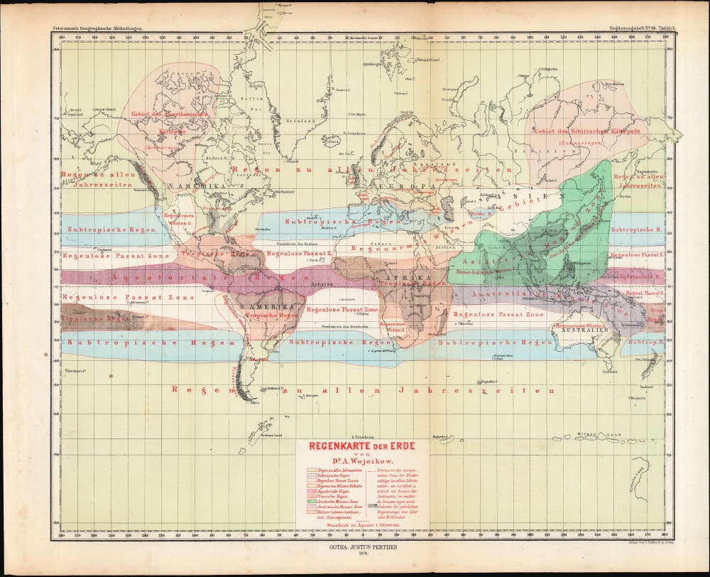
Regenkarte der Erde.
1874 (dated) 11 x 12.5 in (27.94 x 31.75 cm) 1 : 135000000
1874 (dated) 11 x 12.5 in (27.94 x 31.75 cm) 1 : 135000000
Description
A colorful map of the world on a Mercator Projection demonstrating climate regions, produced by Alexander Voeikov and published in 1874 in Petermann's Geographische Mitteheilungen.
A Closer Look
Adopting a Mercator Projection, the map displays the world with color shading used to indicate climate zones, such as tropical, subtropical, desert areas, and so on. A red dashed line further divides Europe into regions depending on seasonal rains (summer rain versus autumn rain). Black horizontal and vertical lines denote areas where annual rainfall exceeds 1200 millimeters, mostly around the Equator. The geography of the Arctic and Antarctic remain incomplete, but with partial coasts based on the latest discoveries.Publication History and Census
This map was prepared by Alexander Ivanovich Voeikov (here as Wojeikow), a prominent Russian meteorologist, to accompany an article on isobars. It was printed by Carl Hellfarth and published by Justus Perthes as a part of an 1874 supplementary issue (Ergänzungshefte) to Petermann's Geographische Mitteheilungen. It is independently cataloged among the holdings of the Bayerische Staatsbibliothek, while the Bibliothèque nationale de France catalogs the entire article, including this map.CartographerS
Alexander Ivanovich Voeikov (Александр Иванович Вое́йков; 1842 - 1916) was a Russian meterologist and climatologist who conducted groundbreaking research on climate, especially in his native Russia. He studied at St. Petersburg University before undertaking further studies in Germany, earning a doctorate in 1865 at the University of Göttingen. He traveled extensively throughout the world and helped to establish many meteorological stations. In 1887, he became a professor at his alma mater, St. Petersburg University. Late in his career, he was among the most eminent Russian climate scientists as well as a vocal proponent of vegetarianism. More by this mapmaker...
August Heinrich Petermann (1822 - 1878) was a German cartographer. Petermann attended the 'Geographische Kuntschule' (Geographica School of Art), which was started by Heinrich Berghaus with the support of Alexander von Humboldt, in Potsdam beginning in 1839. Students at the school were obliged to work on many of the school's contracts, including maps for several different atlases. Following his time in Potsdam, Petermann relocated to Edinburgh and London from 1845 to 1854, where he gained insight into the commercial aspects of the cartography business. In 1854, Petermann returned to Gotha, Germany and began working with the Perthes brothers publishers. While working with the Perthes brothers, Petermann founded the journal Petermanns Geographische Mitteilungen, published from 1855 until 2014, long one of the most prominent German-language geography journals. Learn More...
Carl Hellfarth (November 30, 1846 - July 12, 1918) was a German printer. Hellfarth was born in Gotha, Germany. He married Amalie Friederike Marie Möller (1850 - 1916) on June 16, 1873, and they had eight children. Learn More...
Johan Georg Justus Perthes (September 11, 1749 - May 2, 1816) was one of the most important German cartographic engravers of the 19th century. He was born in the Thuringian town of Rudolstadt, the son of a court physician. In 1778, he began working as a bookseller in Gotha. Perthes began his publishing empire shortly thereafter with the 1784 issue of the famed survey of European nobility known as the Almanac de Gotha. In the next year, 1785, he founded the cartographic firm of Justus Perthes Geographische Anstalt Gotha. His son Wilhelm Perthes (1793 - 1853) joined the firm in 1814. Wilhelm had prior publishing experience at the firm of Justus Perthes' nephew, Friedrich Christoph Perthes, who ran a publishing house in Hamburg. After Justus Perthes died in 1816, Wilhelm took charge and laid the groundwork for the firm to become a cartographic publishing titan. From 1817 to 1890. the Perthes firm issued thousands of maps and more than 20 different atlases. Along with the visionary editors Hermann Berghaus (1797 - 1884), Adolph Stieler (1775 - 1836), and Karl Spruner (1803 - 1892), the Perthes firm pioneered the Hand Atlas. When Wilhelm retired, management of the firm passed to his son, Bernhardt Wilhelm Perthes (1821 – 1857). Bernhardt brought on the cartographic geniuses August Heinrich Peterman (1822 - 1878) and Bruno Hassenstein (1839 - 1902). The firm was subsequently passed to a fourth generation in the form of Berhanrd Perthes (1858 – 1919), Bernhard Wilhelm's son. The firm continued in the family until 1953 when, being in East Germany, it was nationalized and run as a state-owned enterprise as VEB Hermann Haack Geographisch-Kartographische Anstalt Gotha. The Justus family, led by Joachim Justus Perthes and his son Wolf-Jürgen Perthes, relocated to Darmstadt where they founded the Justus Perthes Geographische Verlagsanstalt Darmstadt. Learn More...
Source
Wojeikow [Voeikov], A., 'Isobaren und Winde im Januar...', Petermann's Geographische Mitteheilungen, Ergänzungsheft, No. 38, (Gotha: Justus Perthes) 1874.
Petermanns Geographische Mitteilungen (March 16, 1855 - 2004) was a German-language geographical journal published by Justus Perthes in Gotha. Founded by August Heirich Petermann (April 18, 1822 - September 25, 1878), a German cartographer, Petermanns Geographische Mitteilungen was the oldest German-language journal of geography. A considerable part of the journal in the 1890s were accounts written by missionaries from all over the world. It also published exclusive research reports and cartographic material.
Condition
Very good. Light wear along original fold line. Light toning.
References
OCLC 163821224, 494807567.