Digital Image: 1918 Rice Map of the Rio Negro, Brazil
RioNegro-rice-1917_d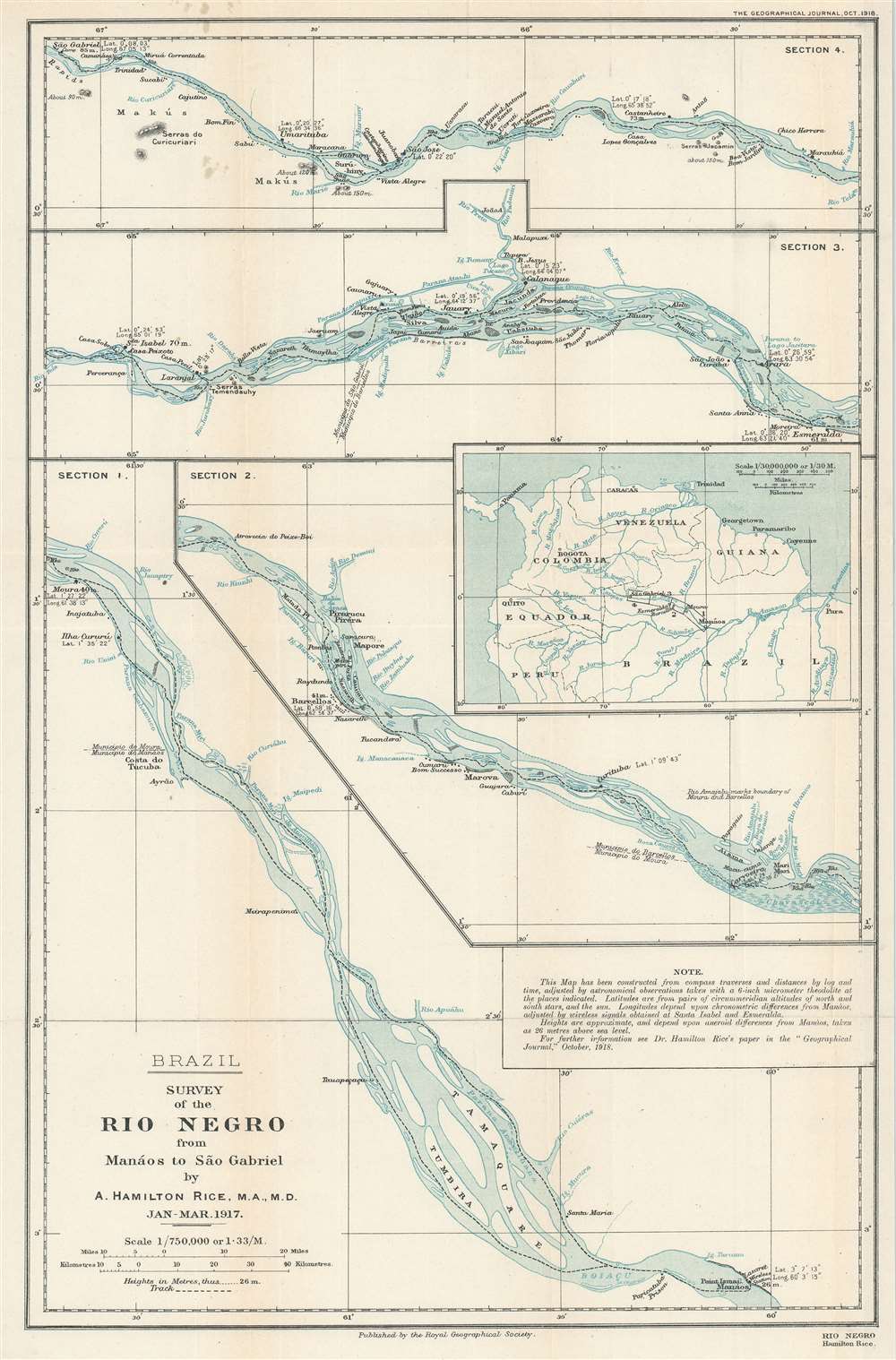

Title
Survey of the Rio Negro from Manáos to São Gabriel.
1917 (dated) 18.75 x 12.5 in (47.625 x 31.75 cm) 1 : 750000
1917 (dated) 18.75 x 12.5 in (47.625 x 31.75 cm) 1 : 750000
Description
FOR THE ORIGINAL ANTIQUE MAP, WITH HISTORICAL ANALYSIS, CLICK HERE.
Digital Map Information
Geographicus maintains an archive of high-resolution rare map scans. We scan our maps at 300 DPI or higher, with newer images being 600 DPI, (either TIFF or JPEG, depending on when the scan was done) which is most cases in suitable for enlargement and printing.
Delivery
Once you purchase our digital scan service, you will receive a download link via email - usually within seconds. Digital orders are delivered as ZIP files, an industry standard file compression protocol that any computer should be able to unpack. Some of our files are very large, and can take some time to download. Most files are saved into your computer's 'Downloads' folder. All delivery is electronic. No physical product is shipped.
Credit and Scope of Use
You can use your digial image any way you want! Our digital images are unrestricted by copyright and can be used, modified, and published freely. The textual description that accompanies the original antique map is not included in the sale of digital images and remains protected by copyright. That said, we put significant care and effort into scanning and editing these maps, and we’d appreciate a credit when possible. Should you wish to credit us, please use the following credit line:
Courtesy of Geographicus Rare Antique Maps (https://www.geographicus.com).
How Large Can I Print?
In general, at 300 DPI, you should at least be able to double the size of the actual image, more so with our 600 DPI images. So, if the original was 10 x 12 inches, you can print at 20 x 24 inches, without quality loss. If your display requirements can accommodate some loss in image quality, you can make it even larger. That being said, no quality of scan will allow you to blow up at 10 x 12 inch map to wall size without significant quality loss. For more information, it is best consult a printer or reprographics specialist.
Refunds
If the high resolution image you ordered is unavailable, we will fully refund your purchase. Otherwise, digital images scans are a service, not a tangible product, and cannot be returned or refunded once the download link is used.
Cartographer S
Alexander Hamilton Rice Jr. (August 29, 1875 - July 21, 1956) was an American explorer, geographer, geologist, and physician remembered for his Amazon Basin expeditions. Rice earned an A.B. from Harvard in 1898 and an M.D. from Harvard Medical School in 1904. He volunteered for the Ambulance Américain, a group of American civilian doctors serving in Europe before the United States entered World War 1, on its Paris surgical staff in 1914 - 1915. He then became director of Hôpital 72, Société de Secours aux Blessés Militaires, a French charity hospital in Paris, from 1915 - 1917. In 1917, after the U.S. entered the war, Rice was commissioned as a lieutenant in the U.S. Naval Reserve and directed the 2nd Naval District Training School for Reserve Officers in Newport, Rhode Island, until 1919. As an explorer and geographer, Rice specialized in rivers. Beginning in 1907, Rice set out on seven expedition and explored 500,000 square miles of the Amazon Basin and mapped many previously unmapped rivers in the northwestern portion of the Basin. On his 1924 - 1925 expedition, Rice became the first to use aerial photography and shortwave radio in mapping. Over the course of his career, Rice published four articles in The Geographical Journal and was closely associated with the Royal Geographical Society. Rice founded Harvard's Institute of Geographical Exploration in 1929, which he directed until it closed in 1952. He also held positions as a Lecturer in Diseases of Tropical South America at the Harvard Medical School, was the Curator of the South American Section of the Peabody Museum of Archaeology and Ethnology, and served as a Trustee of the American Museum of Natural History. Rice married Eleanor Elkins Widener, a widowed RMS Titanic survivor, in 1915, and she accompanied him on several of his expeditions. More by this mapmaker...
Royal Geographical Society (fl. 1830 - present) is a British Society established in 1830 to promote geographical science and exploration. Originally titled the "Geographical Society of London", the RGS received its royal charter from Queen Victoria in 1859 shortly after absorbing several similar but more regional societies including the African Association, the Raleigh Club and the Palestine Association. The RGS sponsored many of the most important and exciting voyages of exploration ever undertaken, including the exploration of Charles Darwin, David Livingstone, Robert Falcon Scott, Richard F. Burton, John Speke, George Hayward, H. M Stanley, Ernest Shackleton and Sir Edmond Hillary. Today, the RGS remains a leading global sponsor of geographical and scientific studies. The Society is based in Lowther Lodge, South Kensington, London. Learn More...
Source
Rice, A.H., 'Notes on the Rio Negro (Amazonas).' The Geographical Journal. Vol. 52, No. 4 (London: Royal Geographical Society) 1918.
References
OCLC 49269333.