Digital Image: 1872 Coffyn Manuscript Masterplan of Saigon - First Map of Saigon
Saigon-coffyn-1862_d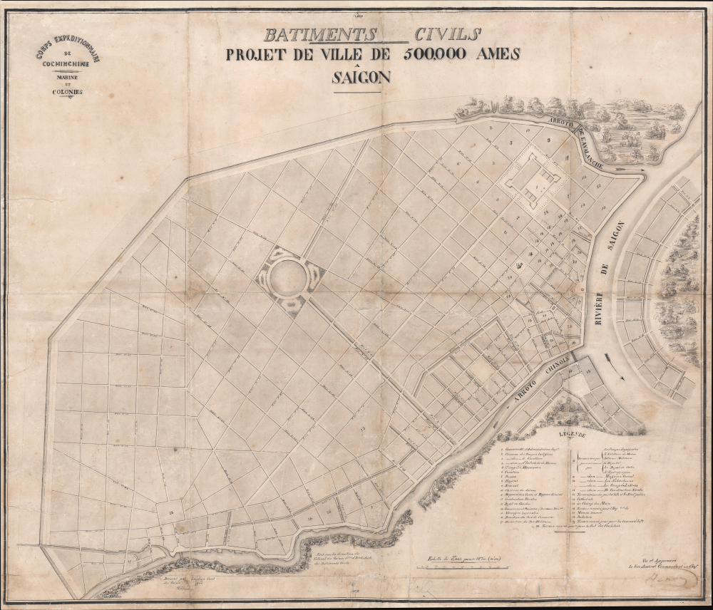


Title
Batiments Civils Projet de Ville de 500,000 Ames Saîgon.
1862 (dated) 26.5 x 30.75 in (67.31 x 78.105 cm) 1 : 10000
1862 (dated) 26.5 x 30.75 in (67.31 x 78.105 cm) 1 : 10000
Description
FOR THE ORIGINAL ANTIQUE MAP, WITH HISTORICAL ANALYSIS, CLICK HERE.
Digital Map Information
Geographicus maintains an archive of high-resolution rare map scans. We scan our maps at 300 DPI or higher, with newer images being 600 DPI, (either TIFF or JPEG, depending on when the scan was done) which is most cases in suitable for enlargement and printing.
Delivery
Once you purchase our digital scan service, you will receive a download link via email - usually within seconds. Digital orders are delivered as ZIP files, an industry standard file compression protocol that any computer should be able to unpack. Some of our files are very large, and can take some time to download. Most files are saved into your computer's 'Downloads' folder. All delivery is electronic. No physical product is shipped.
Credit and Scope of Use
You can use your digial image any way you want! Our digital images are unrestricted by copyright and can be used, modified, and published freely. The textual description that accompanies the original antique map is not included in the sale of digital images and remains protected by copyright. That said, we put significant care and effort into scanning and editing these maps, and we’d appreciate a credit when possible. Should you wish to credit us, please use the following credit line:
Courtesy of Geographicus Rare Antique Maps (https://www.geographicus.com).
How Large Can I Print?
In general, at 300 DPI, you should at least be able to double the size of the actual image, more so with our 600 DPI images. So, if the original was 10 x 12 inches, you can print at 20 x 24 inches, without quality loss. If your display requirements can accommodate some loss in image quality, you can make it even larger. That being said, no quality of scan will allow you to blow up at 10 x 12 inch map to wall size without significant quality loss. For more information, it is best consult a printer or reprographics specialist.
Refunds
If the high resolution image you ordered is unavailable, we will fully refund your purchase. Otherwise, digital images scans are a service, not a tangible product, and cannot be returned or refunded once the download link is used.
Cartographer
Lucien Florent Paul Coffyn (Paul Coffyn; May 20, 1810 - August 5, 1871) was a French military engineer, urban planner, and cartographer active in France's overseas possessions: Algeria, Tahiti, the Marquesas, Nouvelle-Calédonie, China, Saigon, etc. Coffyn was born in Dunkirk, the son of François Joseph Coffyn, a prominent merchant and the U.S. Consul for Pas-de-Calais. He studied military engineering, joining the Marines Corps du Génie. His first service was in Montpellier, followed by Valenciennes and Algeria. He was sent to the Pacific in 1849 to become Chief Engineer of Tahiti and the Marquesas, where he laid out the colonial capital Papeete (Plan terrier du Domaine de l'Etat. Croquis Annexe au Memoire Annuel, 1849; National Library of New Zealand). For this and other work, he was given the Légion d'Honneur in 1856. Afterward, he was sent briefly to Nouvelle-Calédonie. When the Second Italian War of Independence (1589) broke out, he was briefly reassigned to Italy. In 1861, in the wake of the Second Opium War (1856 - 1860), Coffyn was commissioned as the Chief of the French Engineers in China. Later that year, he was made the 'Colonel Commandant le Génie en Cochinchine'. Following his success in this post, he retired, somewhat, taking a position as Director of Engineers at Brest. More by this mapmaker...