1872 Coffyn Manuscript Masterplan of Saigon - First Map of Saigon
Saigon-coffyn-1862$35,000.00


Title
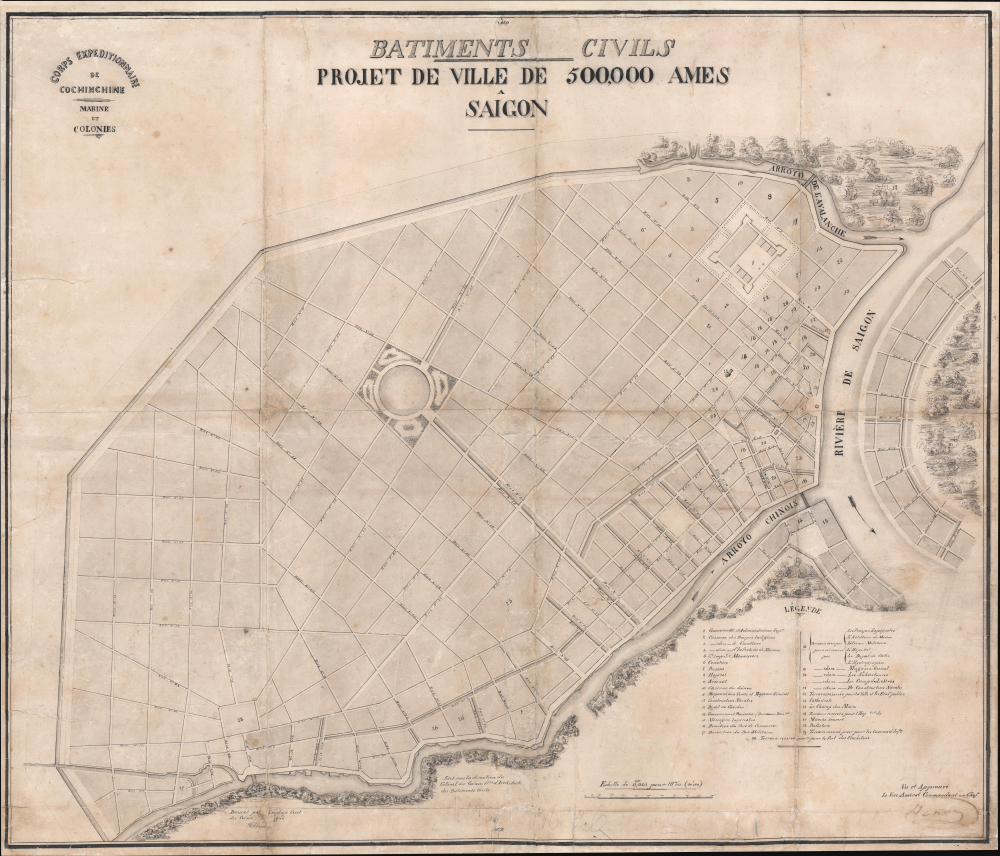
Batiments Civils Projet de Ville de 500,000 Ames Saîgon.
1862 (dated) 26.5 x 30.75 in (67.31 x 78.105 cm) 1 : 10000
1862 (dated) 26.5 x 30.75 in (67.31 x 78.105 cm) 1 : 10000
Description
This is Lucien Florent Paul Coffyn's 1862 manuscript masterplan of Saigon - the first and most significant map of Saigon (Ho Chi Minh City). Coffyn was the French military engineer tasked with transforming a war-torn fort into a model colonial capital. Following the 1861 French occupation of Saigon, authorities resolved to build a new city on the wartorn site at a monumental scale, reflecting boundless imperial ambition. Coffyn, driven by an unwavering belief in the colony's promise, envisioned a grand, European-style metropolis designed to accommodate half a million residents across 25 square kilometers. The present map - exquisitely drafted and signed by both Coffyn and Vice Admiral Louis Bonard, Governor of Cochinchina - is the likely original manuscript submitted for formal approval. Over the subseqeunt decades, Coffyn's street layout and placement of major sites were implemented with fidelity, though not comprehensively, marking this as the foundational document of colonial Saigon. It stands as a unique testament to French imperial planning and an unparalleled artifact of Asian colonial urbanism.
The streets are laid out on a grid of 45° orthogonals radiating from a semicircular plaza on the waterfront. Streets throughout are numbered, with the sole exception being the proposed main street, Rue Impériale (now Hai Bà Trưng Street), which runs northeast from the rondpointe. To the north of Rue Impériale is the Gouvernement et Administration Supérieure in the form of a large fort - the site of Saigon's existing La Citadelle du Phénix. To the Rue Impérial, he planned the city's commercial and industrial district, comprising some 2,300 hectares. The remainder was intended for residential development, including a large public park and water basin. Across the river to the east and south are proposed residential suburbs.
The legend at lower right identifies 30 key locations:Coffyn’s plan left remarkable marks on the city of Saigon. First, it helped to preserve and enhance the natural waterways - a major feature of Saigon - on which almost all local economic activities depend. Largely accessible by river, Saigon had become the main commercial center of southern Vietnam in the 17th century and one of the great trading ports of Southeast Asia in the early 19th century. Port activity had developed strongly there thanks to intense traffic of goods along the arroyos and a massive arrival of merchant ships. However, Saigon’s water network has deteriorated over time due to, on the one hand, the devastation of wars and, on the other hand, the impacts of recent spontaneous urbanization. Indeed, some arroyos have been filled in and others have been seriously polluted. Faced with this situation, local authorities have undertaken major efforts to preserve the waterways available to the southern metropolis. This is evidenced by the recent redevelopment operations of the arroyos, thanks to which urban sanitation is constantly improving. These efforts are giving Saigon’s waterways the opportunity to regain their former glory. We are thus witnessing the recent prosperity of the flower and ornamental plant trade along these arroyos, particularly in the run-up to the country's traditional festival.
Secondly, the organization of urban space on the Western model remains largely dependent on Coffyn's plan. Inspired by the Haussmannian heritage, he brought to the city of Saigon a grid layout in which large streets intersect, perpendicular and parallel to the river and the Arroyos. This spatial configuration remains a major achievement of French influence in the urban domain.
Thirdly, the urban plan drawn up by Coffyn allowed Saigon to create an abundance of green spaces with a large number of parks, gardens and rows of trees along the streets. This green landscape is part of the daily life of several generations of Saigonese. It has also become a source of inspiration for Vietnamese songs and poems. This is the case, for example, of the famous song Con đường có lá me bay (The Street with Flying Tamarind Leaves), through which the cultural wealth of the local streets is expressed. Thanks to its shaded streets, Saigon is made romantic and poetic in the eyes of locals and visitors.
The Coffyn Plan has left an important legacy to the city of Saigon in terms of urban planning. Its achievements have lasted until today, through the preservation of waterways, the development of streets and the creation of green spaces in Western style. This is a remarkable cultural heritage but also an illustration of the harmonious intersection between Vietnamese culture and French civilization, thanks to which Saigon was named 'The Pearl of the Far East'. The Coffyn Plan therefore constitutes the essential premises for the spatial configuration of Saigon in the past, but also for the urban development of Ho Chi Minh City today. (Cam Duong Ly Nguyen, Les prémisses de l’urbanisation de Saigon-Ho Chi Minh-Ville Empreintes du patrimoine culturel français sur l’évolution urbaine locale, pp. 66-7).
A Closer Look
The map is meticulously executed in grisaille pen and wash. It presents an ambitious polygonal city extending west from the Saigon River (Sông Sài Gòn) and exhibiting symmetry and perfection seemingly at odds with the swampy malarial terrain of the Mekong Delta. Coverage extends south to the Arroyo Chinois (Tàu Hủ) and north to the Arroyo de l'Avalanche (Thị Nghè), bother pre-existing rivers. The terrain was to be drained by a series of canals, including a belt canal (canal de ceinture), which would also serve a defensive function, and an expansive network of internal canals.The streets are laid out on a grid of 45° orthogonals radiating from a semicircular plaza on the waterfront. Streets throughout are numbered, with the sole exception being the proposed main street, Rue Impériale (now Hai Bà Trưng Street), which runs northeast from the rondpointe. To the north of Rue Impériale is the Gouvernement et Administration Supérieure in the form of a large fort - the site of Saigon's existing La Citadelle du Phénix. To the Rue Impérial, he planned the city's commercial and industrial district, comprising some 2,300 hectares. The remainder was intended for residential development, including a large public park and water basin. Across the river to the east and south are proposed residential suburbs.
The legend at lower right identifies 30 key locations:
- Gouvernement et Administration Sup.re - Supreme Government and Administration Office, located within La citadelle du Phénix.
- Caserne des Troupes Indigènes - Barracks for Indigenous Troops.
- Caserne de Cavalerie - Barracks for Cavalry.
- Caserne d’Infanterie de Marine - Barracks for the Marines.
- Champ des Manœuvres - Field for Military Manoeuvres.
- Cimetière - Cemetery.
- Prisons - Prisons.
- Hôpital - Hospital.
- Arsenal - Arsenal.
- Caserne du Génie - Barracks for the Engineering Corps.
- Magasine aux Vivres et Magasin Général - Food Storage Magazine and General Magazine.
- Construction Navales - Naval Construction Grounds.
- Dépôt de Charbons - Coal Depot.
- Gouvernement Provisoire (Doit devenir Place Pbl.) - Provisional Government Office (will become the Place Publique).
- Messagerie Impériales - Imperial Post and Telegraph Office.
- Direction du Port de Commerce - Commercial Harbour Master’s Office.
- Direction du Port Militaire - Military Port HQ.
- Terrains occupés provisoirement - Land temporarily occupied by Spanish Troops, Marine Artillery, Military Engineering, Hospital, Coolie’s Depot, Hydrographic Office.
- Terrains occupés provisoirement par Magasin Général - Land temporarily occupied by the General Magazine.
- Terrains occupés provisoirement par Les Subsistances - Land temporarily occupied by the Military Storehouse.
- Terrains occupés provisoirement par Le Camp des Lettrés - Land temporarily occupied by the Camp des Lettrés.
- Terrains occupés provisoirement par De Construction Navales - Land temporarily occupied by the Naval Construction Grounds.
- Terrain réservés pour la Ville et les Établs. Publiques - Land reserved for the City and Public Establishments.
- Cathédrale - Cathedral.
- Le Champ de Mars - Military Parade Ground.
- Terrain réservé pour l’Hôpital de Cho-Quan - Land reserved for the Cho-Quan Hospital.
- Marché couvert - Covered Market.
- Préfecture - Prefecture Offices.
- Terrain réservé provisoirement pour les Casernes d’Infanterie - Land provisionally reserved for the Infantry Barracks.
- Terrain réservé provisoirement pour le fort des Clochetons - Land provisionally reserved for the Bell Tower.
Signed
The map is signed twice. Coffyn's signature appears in brown pen at bottom center below his title, Fait sous la direction du Colonel du Genie, Architecte des Bâtiments Civile (under the direction of Colonel of Engineers, Architect of Public Buildings). A second signature, in the lower right corner, below the text Vu and Approuvé Le Vice-Amiral Commandant en Chef (Seen and Approved, The Vice-Admiral Commander-in-Chief), is that of Vice Admiral Louis Adolphe Bonard (1805 -1867), Governor of Cochinchina.Context and Legacy: A Scholar's View
The Vietnamese historian Cam Duong Ly Nguyen explains the legacy Coffyn’s plan (translated from French):Secondly, the organization of urban space on the Western model remains largely dependent on Coffyn's plan. Inspired by the Haussmannian heritage, he brought to the city of Saigon a grid layout in which large streets intersect, perpendicular and parallel to the river and the Arroyos. This spatial configuration remains a major achievement of French influence in the urban domain.
Thirdly, the urban plan drawn up by Coffyn allowed Saigon to create an abundance of green spaces with a large number of parks, gardens and rows of trees along the streets. This green landscape is part of the daily life of several generations of Saigonese. It has also become a source of inspiration for Vietnamese songs and poems. This is the case, for example, of the famous song Con đường có lá me bay (The Street with Flying Tamarind Leaves), through which the cultural wealth of the local streets is expressed. Thanks to its shaded streets, Saigon is made romantic and poetic in the eyes of locals and visitors.
The Coffyn Plan has left an important legacy to the city of Saigon in terms of urban planning. Its achievements have lasted until today, through the preservation of waterways, the development of streets and the creation of green spaces in Western style. This is a remarkable cultural heritage but also an illustration of the harmonious intersection between Vietnamese culture and French civilization, thanks to which Saigon was named 'The Pearl of the Far East'. The Coffyn Plan therefore constitutes the essential premises for the spatial configuration of Saigon in the past, but also for the urban development of Ho Chi Minh City today. (Cam Duong Ly Nguyen, Les prémisses de l’urbanisation de Saigon-Ho Chi Minh-Ville Empreintes du patrimoine culturel français sur l’évolution urbaine locale, pp. 66-7).
Publication History and Census
This is a unique original manuscript, sign by its draftsman, Paul Coffyn, and by the person who commissioned it, Louis Adolphe Bonard. It was drafted in 1862, in the year following the Franco-Spanish conquest of Saigon. In addition to this map, there is another known manuscript variant, clearly a copy of the present work, drafted in color and wash by an anonymous author (see Archives Nationales d'Outre-Mer.) That example is not signed, though it does add a hospital name (#26), further suggesting a later date. Otherwise, this map is the unique premier map of Saigon. A once in a lifetime acquisition opportunity.Cartographer
Lucien Florent Paul Coffyn (Paul Coffyn; May 20, 1810 - August 5, 1871) was a French military engineer, urban planner, and cartographer active in France's overseas possessions: Algeria, Tahiti, the Marquesas, Nouvelle-Calédonie, China, Saigon, etc. Coffyn was born in Dunkirk, the son of François Joseph Coffyn, a prominent merchant and the U.S. Consul for Pas-de-Calais. He studied military engineering, joining the Marines Corps du Génie. His first service was in Montpellier, followed by Valenciennes and Algeria. He was sent to the Pacific in 1849 to become Chief Engineer of Tahiti and the Marquesas, where he laid out the colonial capital Papeete (Plan terrier du Domaine de l'Etat. Croquis Annexe au Memoire Annuel, 1849; National Library of New Zealand). For this and other work, he was given the Légion d'Honneur in 1856. Afterward, he was sent briefly to Nouvelle-Calédonie. When the Second Italian War of Independence (1589) broke out, he was briefly reassigned to Italy. In 1861, in the wake of the Second Opium War (1856 - 1860), Coffyn was commissioned as the Chief of the French Engineers in China. Later that year, he was made the 'Colonel Commandant le Génie en Cochinchine'. Following his success in this post, he retired, somewhat, taking a position as Director of Engineers at Brest. More by this mapmaker...
Condition
Good. Manuscript and wash. Laid down on archival paper. Some wear on old fold lines. Soiling.
References
Archives Nationales d'Outre-Mer (ANOM, Aix-en-Provence): DFC Asie. Cote XXV/mémoires/104/51. Burlat, Anne, Processus Institutionnels et Dynamique Urbaine dans l'Urbanisation Contemporaine de Ho Chi Minh-Ville, 1988-1998. Planification, Production, Gestion des Secteurs d'Habitat, Ph.D. Thesis, Université de Lyon II (Novembre 2001), pp. 36-52. Harms, Erik, Luxury and Rubble: Civility and Dispossession in the New Saigon, (University of California Press, 2016) p. 137. Herbelin, Caroline, Christophe Bertrand, Jean-François Klein (eds.), Indochine des Territoires et des Hommes, 1856-1956 (Paris: Musée de l'Armée, 2013), p. 84. Cam Duong Ly NGUYEN, 'Les prémisses de l’urbanisation de Saigon-Ho Chi Minh-Ville Empreintes du Patrimoine Culturel Français sur l’Évolution Urbaine Locale', Faire Savoirs, #12 (Décembre 2015), pp. 59-68. Société des Études Indochinoises, Part I (1974), p. 110. Wright, Gwendolyn, The Politics of Design in French Colonial Urbanism (1991), p. 171.