1725 De l'Isle/ Buache Map of Saint Domingue / Hispaniola
SaintDomingue-delisle-1745$650.00

Title
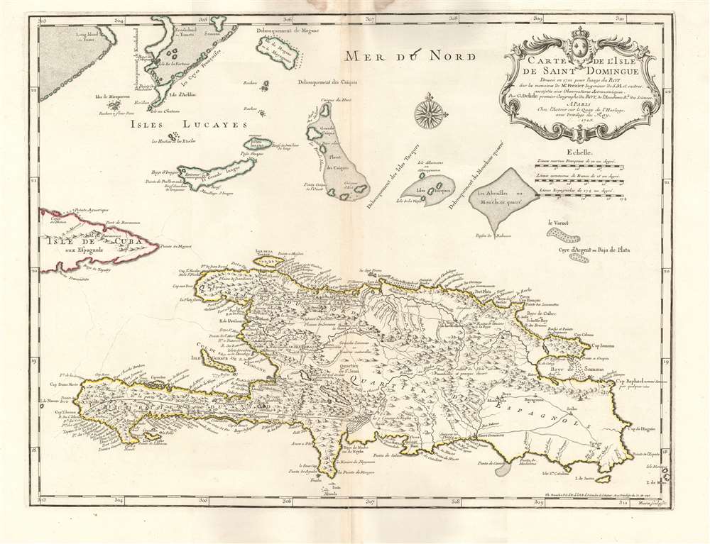
Carte de l'Isle de Saint Domingue.
1745 (dated) 19 x 24.5 in (48.26 x 62.23 cm) 1 : 1300000
1745 (dated) 19 x 24.5 in (48.26 x 62.23 cm) 1 : 1300000
Description
This is a 1745 Phillipe Buache edition of Guillaume De l'Isle's beautifully engraved 1725 map of the island of Hispaniola or Saint Domingue, modern-day Haiti and the Dominican Republic. It is considered one of the best and most detailed maps of the island if its generation.
A Closer Look
It is based on, but not a rote copy of, Amédée-Françis Frézier's 1722 Isle de S. Domingue et débouquemens circonvoisins. As such, it is one of the best-informed maps of the island available. Frézier was sent to Saint Domingue in 1719 to oversee the fortification of the French Colony, and during the course of these labors he also produced his 1722 map. Even so, the map's topographical features are largely rendered pictorially. Lakes, rivers, and towns are marked and named, including Santo Domingo and Port-au-Prince. The map includes descriptive notations to flesh out these details: 'toute ce milieu de l'isle est montueux et presque desert,' for example. (All this central part of the island is mountainous and nearly deserted.)The Cattle Market
In the central part of the island is the town of Hincha. This village, founded by Spanish settlers in 1704, was economically significant beyond its small size: it was a cattle town able to capitalize on selling beef to the neighboring French colony where it was more than seven times as expensive than in the Spanish quarters of the island.Samaná
The map illustrates the Baye de Samana, now known as a winter mating ground for humpback whales. Partially enclosing the bay, to the north, is the Cap de Samaná: an important instance of this peninsula being correctly depicted as an island (albeit with a lake and two streams making this depiction ambiguous.) It is odd that the erroneous insular Samana would appear almost entirely in French cartography subsequent to the De l'Isle: D'Anville, Bellin and Vaugondy all perpetuate the canard.The Bahamas
De l'Isle's map diverges sharply from Frézier's in its depiction of the Bahamas. Placenames, topology, and the shallows differ sharply. The version of these islands that appeared on Frézier's 1722 map would be closely copied by D'Anville and Vaugondy, among others. De l'Isle appears to be relying on a different model - his depiction of the Turcs, Caicos, and Bahamas do not resemble even De l'Isle's own earlier printed maps. Between Acklins Island and Samana Cay is a string of islands named 'Les Cayes Françoises' which make no such appearance on the Frézier.Publication History and Census
This map was engraved for inclusion with De l'Isle's atlases in 1725. This does not aid us in the census, as his atlases were made-to-order with varying content, and did not include printed title pages. His student, Philippe Buache, took over the firm in partnership with De l'Isle's widow, and it is his imprint (with the date of 1745) that appears here. There are four versions of this map that appear in Tooley: the 1725 first state, Buache's second state of 1745, and the 1780 Dezauche third state. The 1730 Covens and Mortier edition is a different engraving. These are well represented in institutional collections.CartographerS
The De L'Isle family (fl. c. 1700 - c. 1760) (also written Delisle) were, in composite, a mapmaking tour de force who redefined early 18th century European cartography. Claude De L'Isle (1644 -1720), the family patriarch, was Paris based a historian and geographer under Nicholas Sanson. De L'Isle and his sons were proponents of the school of "positive geography" and were definitive figures, defining the heights of the Golden Age of French Cartography. Of his twelve sons, four, Guillaume (1675 - 1726), Simon Claude (1675 - 1726), Joseph Nicholas (1688 - 1768) and Louis (1720 - 1745), made a significant contributions to cartography. Without a doubt Guillaume was the most remarkable member of the family. It is said that Guillaume's skill as a cartographer was so prodigious that he drew his first map at just nine years of age. He was tutored by J. D. Cassini in astronomy, science, mathematics and cartography. By applying these diverse disciplines to the vast stores of information provided by 18th century navigators, Guillaume created the technique that came to be known as "scientific cartography", essentially an extension of Sanson's "positive geography". This revolutionary approach transformed the field of cartography and created a more accurate picture of the world. Among Guillaume's many firsts are the first naming of Texas, the first correct map of the Mississippi, the final rejection of the insular California fallacy, and the first identification of the correct longitudes of America. Stylistically De L'Isle also initiated important changes to the medium, eschewing the flamboyant Dutch style of the previous century in favor of a highly detailed yet still decorative approach that yielded map both beautiful and informative. Guillaume was elected to the French Academie Royale des Sciences at 27. Later, in 1718, he was also appointed "Premier Geographe du Roi", an office created especially for him. De L'Isle personally financed the publication of most of his maps, hoping to make heavy royalties on their sales. Unfortunately he met an untimely death in 1728, leaving considerable debt and an impoverished child and widow. De L'Isle's publishing firm was taken over by his assistant, Phillipe Buache who became, posthumously, his son in law. The other De L'Isle brothers, Joseph Nicholas and Louis De L'Isle, were employed in the Service of Peter the Great of Russia as astronomers and surveyors. They are responsible for cataloguing and compiling the data obtained from Russian expeditions in the Pacific and along the northwest coast of America, including the seminal explorations of Vitus Bering and Aleksei Chirikov. The De L'Isles, like their rivals the Vaugondys , must be considered speculative geographers. Speculative geography was a genre of mapmaking that evolved in Europe, particularly Paris, in the middle to late 18th century. Cartographers in this genre would fill in unknown areas on their maps with speculations based upon their vast knowledge of cartography, personal geographical theories, and often dubious primary source material gathered by explorers and navigators. This approach, which attempted to use the known to validate the unknown, naturally engendered many rivalries. The era of speculatively cartography effectively ended with the late 18th century explorations of Captain Cook, Jean Francois de Galaup de La Perouse, and George Vancouver. More by this mapmaker...
Phillipe Buache (February 7, 1700 - January 24, 1773) was a late 18th century French cartographer and map publisher. Buache began his cartographic career as the workshop assistant and apprentice to the important and prolific cartographer Guillaume de L'Isle. Upon De L'Isle's untimely death, Buache took over the publishing firm cementing the relationship by marrying De L'Isle's daughter. Over the years, Bauche republished many of De L'Isle's maps and charts. Buache was eventually appointed Premier Geographe du Roi, a position created-for and previously held by Guillaume de L'Isle. Buache is most respected for his introduction of hachuring as a method from displaying underwater elevation on a two dimensional map surface. Buache compiled maps based upon geographic knowledge, scholarly research, the journals of contemporary explorers and missionaries, and direct astronomical observation. Nevertheless, even in 18th century Paris geographical knowledge was severely limited - especially regarding those unexplored portions of the world, including the poles, the Pacific northwest of America, and the interior of Africa and South America. In these areas the Buache, like his primary rival Robert de Vaugondy, must be considered a speculative geographer or 'positive geographer'. Speculative geography was a genre of mapmaking that evolved in Europe, particularly Paris, in the middle to late 18th century. Cartographers in this genre would fill in unknown areas on their maps with speculations based upon their vast knowledge of cartography, personal geographical theories, and often dubious primary source material gathered by explorers and navigators. This approach, which attempted to use the known to validate the unknown, naturally engendered many rivalries. Buache's feuds with other cartographers, most specifically Didier Robert De Vaugondy, resulted in numerous conflicting papers being presented before the Academie des Sciences, of which both were members. The era of speculatively cartography effectively ended with the late 18th century explorations of Captain Cook, Jean Francois de Galaup de La Perouse, and George Vancouver. Buache was succeeded by his nephew Jean-Nicholas Buache de Neuville. Learn More...
Amédée-François Frézier (1682 - October 26, 1773) was a French military engineer, mathematician, spy, and explorer. He was born in Savoy to a professor and lawyer. He was sent to be educated in Paris, where he studied science and theology, and wrote his thesis on Astronomy and Navigation. He went on to study art and architecture in Italy with particular attention to fortifications. On his return to France in 1700 he was commissioned to the military: by 1712 he had risen to a lieutenant-colonelcy of Army Intelligence, and was sent to South America - in the guise of a merchant captain - to study defense fortifications, ports, and the coastal charts of Spanish Colonial Chile and Peru. The journey would result in the production of more than a dozen maps. In addition to his espionage work, he reported on the flora and fauna and produce of the regions he visited - bringing back to Europe specimens of native American strawberry, his namesake fruit. He would travel again in 1719, assigned as Engineer-in-Chief to Santo Domingo and tasked with the fortification of the colony; to this end he produced a map of the island and a plan of Santo Domingo. He returned to Europe, was rewarded for his labors, and went on to design fortifications in Philippsburg and Landau. In 1739, he was made Director of Fortifications for Brittany. Learn More...
Condition
Very good. Some reinstatement of margin at top, not affecting printed image. Else excellent condition with original outline color.
References
OCLC 11908357. Rumsey (1725), 4764.000. Tooley, R. V., The Mapping of America (London), 1980, #61, p. 25.