Digital Image: 1826 Manuscript Map: HMS Mersey's Anchorages at Isla Santa and Pacasmayo, Peru
Santa-mersey-1826_d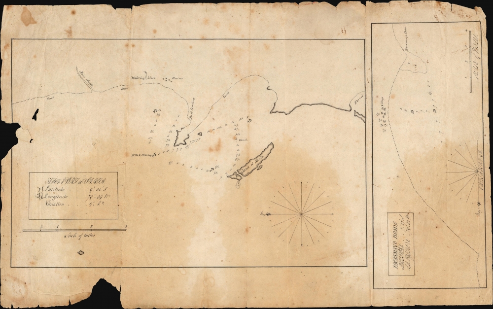

Title
The Port of Santa. / Pacasmayo Roads.
1826 (undated) 8 x 14.25 in (20.32 x 36.195 cm) 1 : 63360
1826 (undated) 8 x 14.25 in (20.32 x 36.195 cm) 1 : 63360
Description
FOR THE ORIGINAL ANTIQUE MAP, WITH HISTORICAL ANALYSIS, CLICK HERE.
Digital Map Information
Geographicus maintains an archive of high-resolution rare map scans. We scan our maps at 300 DPI or higher, with newer images being 600 DPI, (either TIFF or JPEG, depending on when the scan was done) which is most cases in suitable for enlargement and printing.
Delivery
Once you purchase our digital scan service, you will receive a download link via email - usually within seconds. Digital orders are delivered as ZIP files, an industry standard file compression protocol that any computer should be able to unpack. Some of our files are very large, and can take some time to download. Most files are saved into your computer's 'Downloads' folder. All delivery is electronic. No physical product is shipped.
Credit and Scope of Use
You can use your digial image any way you want! Our digital images are unrestricted by copyright and can be used, modified, and published freely. The textual description that accompanies the original antique map is not included in the sale of digital images and remains protected by copyright. That said, we put significant care and effort into scanning and editing these maps, and we’d appreciate a credit when possible. Should you wish to credit us, please use the following credit line:
Courtesy of Geographicus Rare Antique Maps (https://www.geographicus.com).
How Large Can I Print?
In general, at 300 DPI, you should at least be able to double the size of the actual image, more so with our 600 DPI images. So, if the original was 10 x 12 inches, you can print at 20 x 24 inches, without quality loss. If your display requirements can accommodate some loss in image quality, you can make it even larger. That being said, no quality of scan will allow you to blow up at 10 x 12 inch map to wall size without significant quality loss. For more information, it is best consult a printer or reprographics specialist.
Refunds
If the high resolution image you ordered is unavailable, we will fully refund your purchase. Otherwise, digital images scans are a service, not a tangible product, and cannot be returned or refunded once the download link is used.
Cartographer S
John Bremner (18XX-18XX) was an officer of the British Navy, and a hydrographer. Between 1824 and 827 he served as master aboard HMS Mersey, during that ship's posting to the South America Station of the British Navy. He is known to have produced a handful of manuscript sketches and charts connected with that voyage; one at least was preserved in print (Sketch of the Bay of Santa and Port Samanca on the Coast of Peru 1826) No other part of his life, education or career is known. More by this mapmaker...
John Macpherson Ferguson (August 15, 1784 - June 5, 1855) was a Scottish naval officer who served in the British Royal Navy during the Napoleonic Wars (1803 - 1815) and in the years that followed. Born in Edinburgh, he joined the Navy at the age of 12 and served as a midshipman during the 1801 Battle of Copenhagen. In 1803, he was assigned to HMS Victory under Lord Nelson in the Mediterranean. He was commissioned as a Lieutenant in 1804 and promoted to Captain in 1808. His career was marked by both success and setbacks: he achieved victories at sea but was shipwrecked and captured by the Danish in 1811. After being repatriated, he faced a court-martial for the loss of his ship. Nevertheless, he returned to command on several occasions throughout the rest of the decade. In 1823, he was given command of the newly refitted HMS Mersey, serving off the coast of South America from 1823 to 1827. He ultimately attained the rank of rear admiral. Learn More...