1826 Manuscript Map: HMS Mersey's Anchorages at Isla Santa and Pacasmayo, Peru
Santa-mersey-1826$1,500.00

Title
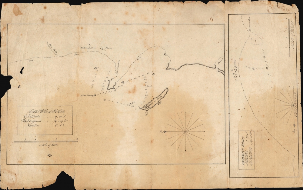
The Port of Santa. / Pacasmayo Roads.
1826 (undated) 8 x 14.25 in (20.32 x 36.195 cm) 1 : 63360
1826 (undated) 8 x 14.25 in (20.32 x 36.195 cm) 1 : 63360
Description
These two c. 1927 manuscript maps, drawn on a single sheet, detail anchorages along the coast of Peru: one of the Island of Santa and the approaches to Pacasmayo. They were taken from the 1824-27 voyage of HMS Mersey during the ship's tenure in South America and were likely the work of either her Captain or her Master.
For Pacasmayo Roads, the draftsman has sketched in the coast with a dotted line. Two anchorages are noted amongst two courses of depth soundings. Pacasmayo point is identified, and village is sketched in, with a few neatly penned trees added. A scale of miles is drawn in the lower right; the title, latitude, and longitude appear in a neat box in the upper left. At the bottom is a half compass rose, with a notation of the magnetic variation.
A Closer Look
The sheet contains two separate charts: The Port of Santa and the Pacasmayo Roads. Both appear off the coast of Peru, at approximately 9° and 7° S. latitude, respectively; both charts are oriented to the east.The Port of Santa is the larger of the two. The title, latitude, longitude, and magnetic variation are neatly presented in a simple box cartouche with a scale of miles below. A simple compass rose appears at the lower right. The Island of Santa is drawn near the center; between it and the point now known as Infiernillo, a triangle of depth soundings appears. Four good anchorages are noted, one of which is labeled HMS Mersey. Much of the coastline is indefinite, marked with a dotted line and labeled 'surf'. A point near the site of present-day Puerto Santa is marked 'best landing.' The mouth of the River Santa is marked, along with a good watering place. No settlement is shown, but just north of present-day Santo, ruins are marked.For Pacasmayo Roads, the draftsman has sketched in the coast with a dotted line. Two anchorages are noted amongst two courses of depth soundings. Pacasmayo point is identified, and village is sketched in, with a few neatly penned trees added. A scale of miles is drawn in the lower right; the title, latitude, and longitude appear in a neat box in the upper left. At the bottom is a half compass rose, with a notation of the magnetic variation.
The Author
These two charts are best attributed to the Master of HMS Mersey, John Bremner, or her Captain, John MacPherson Ferguson. Bremner is the more likely candidate; he was the author of a printed work, 'Sketch of the Bay of Santa and Port Samanca on the Coast of Peru 1826'. Ferguson's and Bremner's observations, but not these charts, were also captured in print in the Admiralty publication Memoir on The Navigation of South America, to Accompany a Chart of That Station. (Though the Memoir had a publication date of 1825, it contained updates as late as 1828.) Ferguson's text in the Memoir agrees with these charts in terms of position, depth soundings, and location details.Publication History and Census
This manuscript was drawn, probably by ship's Master John Bremner, no later than 1828 but likely in the vicinity of 1826 during HMS Mersey's posting off South America. A handful of Bremner's manuscripts survive in British archives, but we are not aware of any that have reached the market. We are aware of only one printed chart with his name attached (see above), but we identify only a single example of it in institutional collections. The present work, being a manuscript draught, is one of a kind.CartographerS
John Bremner (18XX-18XX) was an officer of the British Navy, and a hydrographer. Between 1824 and 827 he served as master aboard HMS Mersey, during that ship's posting to the South America Station of the British Navy. He is known to have produced a handful of manuscript sketches and charts connected with that voyage; one at least was preserved in print (Sketch of the Bay of Santa and Port Samanca on the Coast of Peru 1826) No other part of his life, education or career is known. More by this mapmaker...
John Macpherson Ferguson (August 15, 1784 - June 5, 1855) was a Scottish naval officer who served in the British Royal Navy during the Napoleonic Wars (1803 - 1815) and in the years that followed. Born in Edinburgh, he joined the Navy at the age of 12 and served as a midshipman during the 1801 Battle of Copenhagen. In 1803, he was assigned to HMS Victory under Lord Nelson in the Mediterranean. He was commissioned as a Lieutenant in 1804 and promoted to Captain in 1808. His career was marked by both success and setbacks: he achieved victories at sea but was shipwrecked and captured by the Danish in 1811. After being repatriated, he faced a court-martial for the loss of his ship. Nevertheless, he returned to command on several occasions throughout the rest of the decade. In 1823, he was given command of the newly refitted HMS Mersey, serving off the coast of South America from 1823 to 1827. He ultimately attained the rank of rear admiral. Learn More...
Condition
Poor. Manuscript pen and ink,. Several marginal tears , one with some loss of border. Areas of staining.