Digital Image: 1847 Disturnell Map of Mexico during the Mexican-American War
SeatofWarMexico-disturnell-1847_d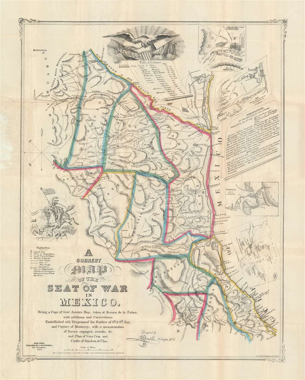

Description
FOR THE ORIGINAL ANTIQUE MAP, WITH HISTORICAL ANALYSIS, CLICK HERE.
Digital Map Information
Geographicus maintains an archive of high-resolution rare map scans. We scan our maps at 300 DPI or higher, with newer images being 600 DPI, (either TIFF or JPEG, depending on when the scan was done) which is most cases in suitable for enlargement and printing.
Delivery
Once you purchase our digital scan service, you will receive a download link via email - usually within seconds. Digital orders are delivered as ZIP files, an industry standard file compression protocol that any computer should be able to unpack. Some of our files are very large, and can take some time to download. Most files are saved into your computer's 'Downloads' folder. All delivery is electronic. No physical product is shipped.
Credit and Scope of Use
You can use your digial image any way you want! Our digital images are unrestricted by copyright and can be used, modified, and published freely. The textual description that accompanies the original antique map is not included in the sale of digital images and remains protected by copyright. That said, we put significant care and effort into scanning and editing these maps, and we’d appreciate a credit when possible. Should you wish to credit us, please use the following credit line:
Courtesy of Geographicus Rare Antique Maps (https://www.geographicus.com).
How Large Can I Print?
In general, at 300 DPI, you should at least be able to double the size of the actual image, more so with our 600 DPI images. So, if the original was 10 x 12 inches, you can print at 20 x 24 inches, without quality loss. If your display requirements can accommodate some loss in image quality, you can make it even larger. That being said, no quality of scan will allow you to blow up at 10 x 12 inch map to wall size without significant quality loss. For more information, it is best consult a printer or reprographics specialist.
Refunds
If the high resolution image you ordered is unavailable, we will fully refund your purchase. Otherwise, digital images scans are a service, not a tangible product, and cannot be returned or refunded once the download link is used.
Cartographer S
John Disturnell (1801-1877) was a New York book and map publisher operating gin the early to middle 19th century. Disturnell worked with various engravers and cartographers over the years including Calvin Smith, J. H. Young, and G. E. Sherman as well as the Ensign, Bridgeman and Fanning group. His primary focus seems to have been New York and vicinity, however, his most significant contribution to U.S. history came from the opposite side of the continent. When Nicholas P. Trist was sent to Mexico to negotiate the 1847 Treaty of Guadeloupe Hidalgo which defined the Mexican-American border at the end of the Mexican-American War, he carried with him Disturnell's Map of America. This map, among other inaccuracies, located El Paso a whopping 34 miles north and 100 miles east of its true location. Since Trist based the border treaty on mileages from El Paso, the obvious subsequent confusion lead to the conflicts that were to follow. The border problems between the United States and Mexico that resulted from this error were not resolved until 1963. More by this mapmaker...
Joseph Goldsborough Bruff (October 2, 1804 - April 14, 1889) was an American artist, adventurer, surveyor, and cartographer active in the mid to late 19th century. Bruff was born in Washington D.C., the son of a wealthy physician, dentist, and inventor (coffee grinder). At 16 he was sent to West Point, but shortly afterwards dismissed for dueling. He subsequently signed on a merchant ship as cabin boy, initiating a five-year career as an itinerant seaman. In 1927 he returned to Washington, taking a position as a draughtsman at the Norfolk Naval Shipyard. Shortly thereafter he transitioned to a higher paid position at Fort Monroe, where he remained for 2 years. Gruff had an arrogant entitled character, but his work was exacting and much admired, enough so that in 1839, he was hired as a draftsman for the Army Bureau of Topographical Engineers. There he compiled and published numerous maps from hand-drawn field maps prepared by explorers. His work from this period includes drafting the important exploration maps of John C. Frémont (who became a personal friend), and the first map of Florida after statehood. In 1849, Bruff, like many Americans caught gold fever. He leveraged his connections in Washington to finance the Washington City and California Mining Association. The well-funded expedition traveled overland in a caravan of sixty-six men and 14 wagons. While Bruff did not discover gold in California, he did travel extensively throughout he gold region producing numerous important maps and diagrams. He returned to Washington via ship, landing in New York in July of 1851. Back in Washington he took work with the Treasury department in the Office of the Supervising Architect. He helped in the design and construction of the DC Treasury Building as well as Treasury offices around the country. Bruff continued his position with the treasury until his death in 1889, at which time he was the oldest active U.S. Government employee. Bruff is interred at the National Congressional Cemetery in Washington. D.C. Learn More...
John Probst (March 11, 1805 - March 11, 1896) was a German-American lithographer active in the middle part of the 19th century. Probst was born in Bremen, Germany, in 1805 and emigrated to the United States in 1831. He ran a prosperous commercial lithography studio from at least 1847 through the 1879s. Probst died on this birthday in his home at 268 Berry, Street, Williamsburg, Brooklyn, aged 91. Learn More...
Edward Jones (fl. c. 1844 - 1850) was an American lithographer based in New York in the middle of the 19th century. Jones worked both independently and in various partnerships. He partnered with Edward S. Palmer in 1844, publishing as 'Jones and Palmer' and later from 1847to 1849, with George W. Newman, publishing as 'Jones and Newman'. He was still active independently as late as 1850. Jones and Newman were both lithographers and chromolithographers, winning a several medal for their work in 1849. Learn More...
References
Rumsey 0097.001. OCLC 55857714.