This item has been sold, but you can get on the Waitlist to be notified if another example becomes available, or purchase a digital scan.
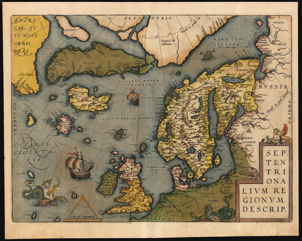
1570 / 1641 Ortelius Map of the North Atlantic / Arctic: Scandinavia, Britain, Greenland
SeptentrionaliumRegionum-ortelius-1570-2$1,000.00


Title
Septentrionalium Regionum Desrip.
1570 (undated) 14.5 x 20 in (36.83 x 50.8 cm) 1 : 10000000
1570 (undated) 14.5 x 20 in (36.83 x 50.8 cm) 1 : 10000000
Description
One of Abraham Ortelius' most interesting maps, this is his 1570 map of Scandinavia and the Arctic. During the Age of Discovery, these northern parts of the world represented regions as remote and unfamiliar as the coasts of America, Africa, and Asia.
The Spanish verso text paraphrases the Zeno narrative but also references the English having found Frisland, naming it 'West England.' This refers to Martin Frobisher's July 1576 sighting of southern Greenland - which the explorer took to be Frisland. He promptly claimed the newly-discovered land for Queen Elizabeth I.
A Closer Look
The map covers the northern regions from the English Channel to just south of the North Pole and from America to Russia, including England, Scandinavia, Finland, Denmark, Iceland, and Greenland, as well as parts of America. It was a significant vector for the dissemination of the geographical fraud of Nicolo Zeno, as evidenced by the appearance of Estotiland on the coast of North America and the phantom islands of Icaria, Drogeo, and Frisland. Zeno's depiction of Greenland is also preserved, as are Mercator's speculative Arctic islands.Ortelius's Sources
Part of Ortelius' genius was his aptitude as a compiler and editor, synthesizing the best sources available. For this map, these included the 1539 Olaus Magnus Carta marina et Descriptio Septentrionalium Terrarium for Scandinavia and Iceland and Nicolo Zeno's 1558 Carta Da Navegar De Nicolo et Antonio Zeni Furono In Tramontana Lano MCCCLXXX for Estotiland, Iceland, Greenland, Icaria, and Frisland. Ortelius also drew on Anthony Jenkinson's 1562 map of Russia and Gerard Mercator's world maps of 1564 and 1569 for the Arctic.Zeno's Spurious yet Tenacious Geography
This is one of the few maps to depict Estotiland and Drogeo, both drawn from the narrative of the Zeno brothers, supposedly written in the 14th century, before Columbus, but published in 1558 as a deliberate fraud by the Venetian merchant and statesman Nicolo Zeno. Most subsequent cartographers associated Estotiland with Labrador based upon Zeno's description,… the fishing vessel 'Frise' was blown westward by a storm, and arrived at a land named 'Estotiland,' whose inhabitants traded with 'Engroenelandt.' This country, 'Estotiland,' was very fertile, and had mountains inland. The king of this country possessed books written in Latin, which he did not understand. The language that he spoke and his subjects shared no similarity to that of the Vikings. The king of Estotiland, seeing that his guests sailed safely with the aid of an instrument (the compass), persuaded them to make a maritime expedition to another land to the south called 'Drogeo.'Also prominent are Zeno's imaginary islands of Icaria and Frisland. As with Estotiland, Zeno credited his 14th-century predecessors with discovering these mysterious islands, which appeared first on his own 1558 map and were eagerly copied by later mapmakers thirsty for geographical data. Despite Zeno's work being a fraudulent Venetian attempt to co-opt the achievements of the Genoese Christopher Columbus, it remained influential in the 16th and 17th centuries, absent better reconnaissance of the North Atlantic. Not only Ortelius but his competitor De Jode and the Dutch mapmakers of the early 17th century embraced the Zeno geography. It appears likely that Zeno's fraud came to Ortelius and Mercator not directly but via the intermediary of Ruscelli's 1561 edition of the Zeno Map. It appeared in Ruscelli's edition of Ptolemy, which primarily consisted of the works of Ptolemy and Gastaldi, the two great pillars of geography. The appearance of the Zeno map amidst the works of these two great authorities would have had the effect of bestowing their imprimatur on Zeno's imposture.
The Spanish verso text paraphrases the Zeno narrative but also references the English having found Frisland, naming it 'West England.' This refers to Martin Frobisher's July 1576 sighting of southern Greenland - which the explorer took to be Frisland. He promptly claimed the newly-discovered land for Queen Elizabeth I.
Mercator's Arctic Islands
This is one of the earliest maps to illustrate Gerard Mercator's speculative Arctic Islands. When Mercator published his 1569 wall map introducing the famous Mercator Projection, he recognized the essential problem with his projection was that it massively distorted polar regions. To rectify this, he included a polar projection as an inset on the map. This small projection, later refined in his 1595 Arctic map, introduced Mercator's idea of four arctic islands surrounding an open Arctic Sea, at the center of which was a great whirlpool. Two of those islands are visible here, one unnamed, and the other just north of Norway, labeled Pigmei hic habitant, for Mercator's assertion that it was the home of a race of female pygmies. The channel between the islands, possibly Mercator's interpretation of the Davis Strait, was described as having violent currents. Variants on Mercator's Arctic islands continued to appear in various forms well into the 17th century until the discoveries of Spitzbergen and other factual Arctic islands began to intrude. The islands disappeared entirely in Hondius's 1636 Arctic map Poli Arctici et Circumiacentium Terrarum Descriptio Novissima.Publication History and Census
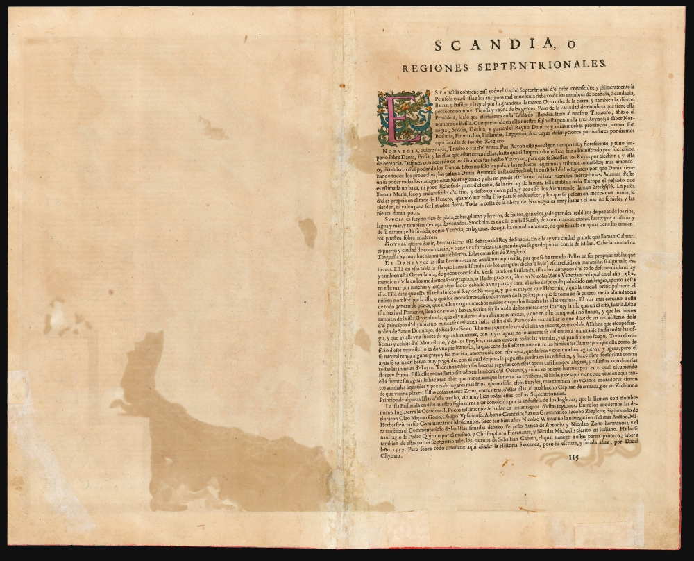
This map was drawn by Abraham Ortelius and engraved by Franz Hogenberg for inclusion in the first modern atlas, Ortelius' Theatrum Orbis Terrarum. It appeared in all editions of that work, beginning in 1570. Based on the typography of the verso text, this example corresponds to the 1609 Spanish edition of the Theatrum, which appeared again in 1612 and 1641; according to van den Broecke, the state of this example corresponds to the final state of the map appearing in the 1641 Spanish edition, of which only twenty-five were printed. The map in its many editions is well represented in institutional collections; however, only one example of this 1641 edition is cataloged, appearing in the collection of the Denver Public Library.CartographerS
Abraham Ortelius (April 14, 1527 - June 28, 1598) also known as Ortels, was a cartographer, geographer, and cosmographer of Brabant, active in Antwerp. He was the creator of the first modern atlas, Theatrum Orbis Terrarum and is a seminal figure in the history of cartography. Along with Gerard Mercator and Gemma Frisius, he was a founder of the Netherlandish school of cartography. His connections with Spain - culminating in his 1575 appointment as Royal Cartographer to King Phillip II of Spain - gave him unmatched access to Spanish geographical knowledge during a crucial period of the Age of Discovery. Ortelius was born in 1527 in Antwerp. In 1547 he entered the Antwerp Guild of Saint Luke as an illuminator of maps. He began trading in books, prints, and maps, traveling regularly to the Frankfurt book and print fair, where in 1554 he met Mercator. He accompanied Mercator on journeys throughout France in 1560 and it was at this time, under Mercator's influence, that he appears to have chosen his career as a scientific geographer. His first published geographic work appeared in 1564, an eight-sheet cordiform world map. A handful of other maps preceded the 1570 publication of the first edition of the Theatrum Orbis Terrarum, which would prove to be his life work. Appearing with but 53 maps in its first edition, Ortelius' work expanded with new maps added regularly. By 1592, it had 134 maps. Many of Ortelius' maps remained the standard for nearly a century. He traveled extensively, but his genius was as a compiler, locating the best informed maps on which to base his own. His contacts throughout Europe and extending even (via the Portuguese) to the Far East were formidable. Moreover, many of his maps were based on his own scholarship, particularly his historical works. His theories of geography were particularly ahead of his time with respect to the notion of continental drift, the possibility of which he mused on as early as 1596, and which would be proven correct centuries later.
In a sense his greatest achievement was his successful navigation of the religious and political violence endemic to his city throughout his adult life: The Dutch Revolt, or Eighty Years' War (1568 - 1648), fully embroiled Antwerp. Although outwardly and officially recognized as Catholic (Arias Montanus vouched for Ortelius' Catholic orthodoxy prior to his appointment as Royal Geographer), Ortelius was able to separate himself from the religious furor which characterized the war in the low countries. Ortelius showed a glimpse of himself in a letter to a friend, regarding humanist Justus Lipsius: 'I do not know whether he is an adherent of the Pope or a Calvinist, but if he has ears to hear, he will neither be one nor the other, for sins are committed on both sides'. Ortelius' own explorations of Biblical history in his maps, and the Christogram contained in his own motto, suggest him to be a religious man, but his abjuration of political religious authorities mark him as an individualist. His tombstone at St Michael's Præmonstratensian Abbey in Antwerp bears the inscription, Quietis cultor sine lite, uxore, prole. ('served quietly, without accusation, wife, and offspring.') More by this mapmaker...
Franz Hogenberg (1535 - 1590), often called 'Master Franz,' was a Flemish engraver active in the late 16th century. Hogenberg was born in Mechelen, the son of Nicolas Hogenberg, where he trained under the cartographer H. Terbruggen. He later relocated to Antwerp where he achieved success as an engraver, working with Abraham Ortelius, Hieronymus Cock, and others. In 1568, his name appeared on the list of those banned from the Netherlands by the Duke of Alva, forcing his family to flee to London. There he engraved for Christopher Saxon's Atlas of England and Wales. By 1570 he emigrated to Germany settling in Cologne. In Cologne he married his second wife, Agnes Lomar, with whom he had six children. In 1579 the couple were briefly imprisoned for holding illicit secret religious meetings, but were released in short order. Along with German cleric George Braun (1541 – March 10, 1622), Hogenberg issued the highly influential city atlas Civitates Orbis Terrarum. The six volume work, with some 546 views, was published between 1572 and 1617 and intended a companion to Abraham Ortelius' Thatrum Orbis Terrarum - thus certain obvious stylistic similarities. In compiling the Civitates Hogenberg took on the role of engraver while most of the editing was left to Georg Braun. Hogenberg died in Cologne, Germany, before the Civitates was completed. After his death, Hogenberg's work was continued by his son, Abraham Hogenberg, who, under the direction of Agnes, his mother, took over his father's enterprise at just 20. Learn More...
Source
Ortelius, A., Theatro del mondo di Abrahamo Ortelio, (Antwerp: Plantin), Spanish Edition, 1641.
Abraham Ortelius' magnum opus, Theatrum Orbis Terrarum, was the world's first regularly produced atlas, which 'set the standards for later atlases . . . It was the first undertaking of its kind to reduce the best available maps to an uniform format.' (Koeman) A modestly-sized work of fifty-three maps in its first edition of May 1570, it was an immediate success: there were three further editions that year, and the work remained in print for a total of 32 editions, the last of which was 1641, well after its author's 1598 death. Ortelius added to his atlas constantly, and by 1595 the Theatrum contained 147 maps. Ortelius is renowned generally as an editor, and indeed much of the Theatrum is compiled from a variety of sources: in such cases, Ortelius was scrupulous in naming his sources. But Ortelius was also a mapmaker in his own right: many of his maps are a distillation of various sources into his own work, and there were many maps - particularly in his atlas of Biblical and ancient history Parergon - which were entirely Ortelius' work. In his role as an editor, Ortelius followed in the footsteps of Munster, whose Cosmographia was, until Ortelius, the best window on the world for the curious European reader. In terms of the artistry of his maps, Ortelius oversaw the first great flourishing of copperplate engraving in the service of cartography to occur in Northern Europe. Ortelius' work provided the model for the atlases of Mercator, Hondius, Blaeu and all their progeny in the 17th century - many of whom were to produce faithful editions of Ortelius' maps in their own productions.
Condition
Very good. Few marginal mends; one invisibly mended tear to lower right, no loss. Original color with a bold strike.
References
OCLC 713085113. Rumsey 10000.099. Van den Broecke, M. Ortelius Atlas Maps 160.7 Van der Krogt, P. C. J., Koeman's Atlantes Neerlandici, (3 Vols), 1200:31. Spies, M. Humanist Conceptions of the Far North in the Works of Mercator and Ortelius, p. 303-318. Burden, P., The Mapping of North America, #40. Germundson, Nils G., 'Die Nordeuropakarte des Abraham Ortelius Septentrionalium Regionum Descriptio', Cartographica Helvetia, 27: 37-46.