Digital Image: 1909 Mawson Map of the Northern Branch of the British Antarctic Expedition
SouthVictoriaLand-mawson-1909_d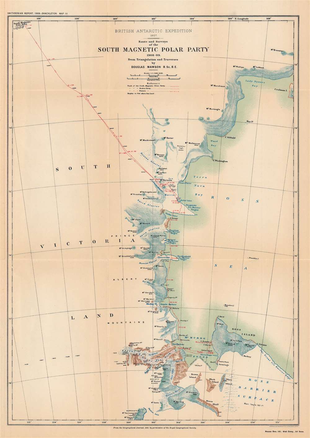

Title
British Antarctic Expedition, 1907 : route and surveys of the South Magnetic Polar Party, 1908-09: from triangulation and traverses.
1909 (dated) 18.5 x 13.25 in (46.99 x 33.655 cm) 1 : 1150000
1909 (dated) 18.5 x 13.25 in (46.99 x 33.655 cm) 1 : 1150000
Description
FOR THE ORIGINAL ANTIQUE MAP, WITH HISTORICAL ANALYSIS, CLICK HERE.
Digital Map Information
Geographicus maintains an archive of high-resolution rare map scans. We scan our maps at 300 DPI or higher, with newer images being 600 DPI, (either TIFF or JPEG, depending on when the scan was done) which is most cases in suitable for enlargement and printing.
Delivery
Once you purchase our digital scan service, you will receive a download link via email - usually within seconds. Digital orders are delivered as ZIP files, an industry standard file compression protocol that any computer should be able to unpack. Some of our files are very large, and can take some time to download. Most files are saved into your computer's 'Downloads' folder. All delivery is electronic. No physical product is shipped.
Credit and Scope of Use
You can use your digial image any way you want! Our digital images are unrestricted by copyright and can be used, modified, and published freely. The textual description that accompanies the original antique map is not included in the sale of digital images and remains protected by copyright. That said, we put significant care and effort into scanning and editing these maps, and we’d appreciate a credit when possible. Should you wish to credit us, please use the following credit line:
Courtesy of Geographicus Rare Antique Maps (https://www.geographicus.com).
How Large Can I Print?
In general, at 300 DPI, you should at least be able to double the size of the actual image, more so with our 600 DPI images. So, if the original was 10 x 12 inches, you can print at 20 x 24 inches, without quality loss. If your display requirements can accommodate some loss in image quality, you can make it even larger. That being said, no quality of scan will allow you to blow up at 10 x 12 inch map to wall size without significant quality loss. For more information, it is best consult a printer or reprographics specialist.
Refunds
If the high resolution image you ordered is unavailable, we will fully refund your purchase. Otherwise, digital images scans are a service, not a tangible product, and cannot be returned or refunded once the download link is used.
Cartographer S
Douglas Mawson (May 5, 1882 – October 14, 1958) was an Australian geologist and explorer who played an important role in the exploration of Antarctica in the early 20th century. He studied geology and mining before taking a professor position at the University of Adelaide. In 1907 – 1909, he joined Ernest Shackleton's Nimrod Expedition, which reached to the furthest south latitude of any expedition to that point. Mawson's party of the expedition was very successful, reaching the South Magnetic Pole and climbing Mt. Erebus. Afterwards, he was appointed to lead the Australasian Antarctic Expedition (1911–1914). Unfortunately, Mawson's two companions during that expedition perished. He led another expedition in 1929 – 1931 which claimed a significant portion of the Antarctic for Australia. Mawson's work and those of his colleagues led to many important discoveries about the geography, geology, and biology of the Antarctic. More by this mapmaker...
Royal Geographical Society (fl. 1830 - present) is a British Society established in 1830 to promote geographical science and exploration. Originally titled the "Geographical Society of London", the RGS received its royal charter from Queen Victoria in 1859 shortly after absorbing several similar but more regional societies including the African Association, the Raleigh Club and the Palestine Association. The RGS sponsored many of the most important and exciting voyages of exploration ever undertaken, including the exploration of Charles Darwin, David Livingstone, Robert Falcon Scott, Richard F. Burton, John Speke, George Hayward, H. M Stanley, Ernest Shackleton and Sir Edmond Hillary. Today, the RGS remains a leading global sponsor of geographical and scientific studies. The Society is based in Lowther Lodge, South Kensington, London. Learn More...
The United States Geological Survey (1878 - Present), aka the U.S.G.S., is a scientific agency of the United States government, which was founded in 1879. USGS scientists study the landscape of the United States, its natural resources, and the natural hazards that threaten it. The organization has four major science disciplines: biology, geography, geology, and hydrology. It is a bureau of the United States Department of the Interior and is the department's only scientific agency. Learn More...
Source
Annual report of the Board of Regents of the Smithsonian Institution ... 1909, (Washington DC: Government Printing Office), House doc. 112, 61st Cong., 2nd sess., Serial Set 5818.
References
OCLC 712806538.