1829 Burr Map of Steuben Counties, New York
Steuben-burr-1829$400.00

Title
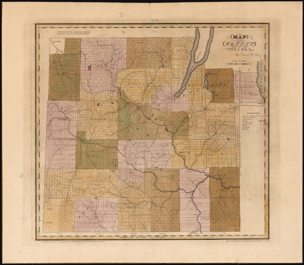
Map of the County of Steuben.
1829 (dated) 17.75 x 19.25 in (45.085 x 48.895 cm) 1 : 151000
1829 (dated) 17.75 x 19.25 in (45.085 x 48.895 cm) 1 : 151000
Description
This is David Burr's 1829 map of Steuben County, New York, south of the Finger Lakes region of western New York, along the Pennsylvania border. The county was part of Ontario County, which had been established in 1789 to administer the lands annexed by New York State in the Phelps and Gorham Purchase of 1788. By the time Burr produced this survey, the Purchase had passed through many changes, undergoing subdivisions into new counties as land was settled and populations grew. This process continued over the course of the 19th century within the new counties themselves, and the present map captures Steuben County during this process of transition, shown after the loss of land to Yates County in 1826 but before the 1854 formation of Schuyler County.
Historical Context
The land of Ontario County, virtually all of Western New York, had been alienated from the Iroquois following the American Revolutionary War (1775 - 1783), and title to sell the land had passed from Massachusetts in 1784 to land investors Oliver Phelps and Nathaniel Gorham in 1788. Later that year, Phelps and Gorham negotiated title to sell these lands from the Iroquois and had begun to do so when they were compelled in 1791 to sell all the unsold land to Robert Morris, who would in turn sell at a massive profit. Steuben County split from Ontario County in 1796, named after the Prussian general Baron von Steuben, who trained and fought alongside American soldiers during the Revolution. In 1826, 60 square miles of Steuben County was added to Yates County: this is the area between Crooked Lake and Seneca Lake here occupied by the map's title north of Tyrone and Reading. In 1854, Steuben would be further reduced in size by losing Tyrone and Jersey to the newly established Schuyler County.A Closer Look
The map breaks the county borders into towns, and further into lots. Actual villages are marked. Some owners of large lots are named. The map includes stage roads and county roads and mills, manufactories, forges, sawmills and churches, are indicated with symbols keyed to a legend at the center right hand of the map.A Planned Canal?
This map was produced during a period in which canal projects - such as the Erie - were in full swing. Within a year, a proposed canal would be undertaken connecting the Conhocton River with Crooked Lake, between Bath and Urbana: there is yet no sign of it on this map. Further downstream of the confluence of the Conhocton and Mud Creek (near present-day Savona) a plot is labeled 'Grand Canal Tract' suggesting that land was being purchased there speculatively in the hope that a canal between the river and Seneca Lake might be forthcoming. The development of the railroads in the 1840s would negatively impact most canal schemes of the early 19th century.Publication History and Census
This map was created by David Burr and engraved by Rawdon, Clark, and Company of Albany and Rawdon, Wright, and Company of New York. It is well represented institutionally. A much-revised 1840 edition of the map is easily distinguished from this one by the addition of many railroads.CartographerS
David Hugh Burr (August 18, 1803 - December 25, 1875) of one of the first and most important truly American cartographers and map publishers. Burr was born in Bridgeport Connecticut in August of 1803. In 1822 Burr moved to Kingsboro, New York to study law. A year and a half later he was admitted to the New York Bar association. Burr must have questioned his choice of careers because shortly after being admitted to the Bar, he joined the New York State Militia. Though largely untrained in the art of surveying, Burr was assigned to work under Surveyor General of New York, Simeon De Witt, to survey several New York Roadways. Seeing a window of opportunity, Burr was able to negotiate with the governor of New York at the time, De Witt Clinton, to obtain copies of other New York survey work in order to compile a map and Atlas of the state of New York. Recognizing the need for quality survey work of its territory, the government of New York heartily endorsed and financed Burr's efforts. The resulting 1829 Atlas of the State of New York was the second atlas of an individual U.S. state and one of the most important state atlases ever produced. Burr went on to issue other maps both of New York and of the United States in general. In cooperation with publishing firm of Illman & Pillbrow, he produced an important New Universal Atlas and, with J.H. Colton, several very important maps of New York City. In recognition of this work, Burr was appointed both "Topographer to the Post office" and "Geographer to the House of Representatives of the United States". Later, in 1855, Burr was assigned to the newly created position of Surveyor General to the State of Utah. Burr retired from the position and from cartographic work in general in 1857 when light of some of his financial misdeeds and frauds came to light. He was accused of submitting false expense reports and underpaying employees, among other indiscretions. More by this mapmaker...
Ralph Rawdon (December 19, 1793 - September 12, 1877) was an American engraver and printer. Born in Connecticut, Rawdon established his engraving and printing firm in Albany, New York, in 1816. He formed a partnership with Vistus batch of Willismtown, Massachusetts, in 1818 that lasted until 1822. He then formed Rawdon, Clark, and Company with Asahel Clark. Rawdon's brother, Freeman Rawdon (August 18, 1802 - September 21, 1859) founded his own engraving and printing firm in New York City sometime after 1825. Freeman Rawdon formed a partnership with Neziah Wright in 1828 and established Rawdon, Wright, and Company. The Rawdon brothers merged their firms on March 1, 1832, and formed Rawdon, Wright, Hatch, and Company. At the time of the merger, Tracy R. Edson joined the firm as its business administrator and ran the company's New Orleans office until 1847. He also played an outsize role in establishing the firm in Philadelphia, Cincinnati, and Boston. Edson was transferred to the New York City office in 1847 to run the entire firm. The company's name was changed to Rawdon, Wright, Hatch, and Edson. The firm won the U.S. government contract to print the first American postage stamps from 1847 - 1851. Rawdon, Wright, Hatch, and Edson merged with seven other firms in 1858 to form the American Bank Note Company. Ralph Rawdon is largely remembered for his role in the founding of the American Bank Note Company and little detail remains about his personal life. Learn More...
Freeman Rawdon (August 18, 1802 - September 21, 1859) was an American artist, engraver, and publisher. Born in Connecticut, Rawdon founded his engraving and printing firm sometime after 1825, likely in New York City. He partnered with Neziah Wright in 1828 and established Rawdon, Wright, and Company of New York City. Rawdon's brother Ralph Rawdon (December 19, 1793 - September 12, 1877) founded his own printing and engraving firm in Albany in 1816, and formed several partnerships between 1818 and 1832. The Rawdon brothers merged their firms on March 1, 1832, and formed Rawdon, Wright, Hatch, and Company. At the time of the merger, Tracy R. Edson joined the firm as its business administrator and ran the company's New Orleans office until 1847. He also played an outsize role in establishing the firm in Philadelphia, Cincinnati, and Boston. Edson was transferred to the New York City office in 1847 to run the entire firm. The company's name was changed to Rawdon, Wright, Hatch, and Edson. The firm won the U.S. government contract to print the first American postage stamps from 1847 - 1851. Rawdon, Wright, Hatch, and Edson merged with seven other firms in 1858 to form the American Bank Note Company. Learn More...
Source
Burr, D., An Atlas of the State of New York, (New York: Burr) 1829.
Condition
Very good. Some toning. Original wash color.
References
OCLC 988609467. Rumsey 0103.037.