1864 Howell Map of the U.S. Civil War Battles of Totopotomoy or Bethesda Church
TolopotomoyBethesda-howell-1864$750.00

Title
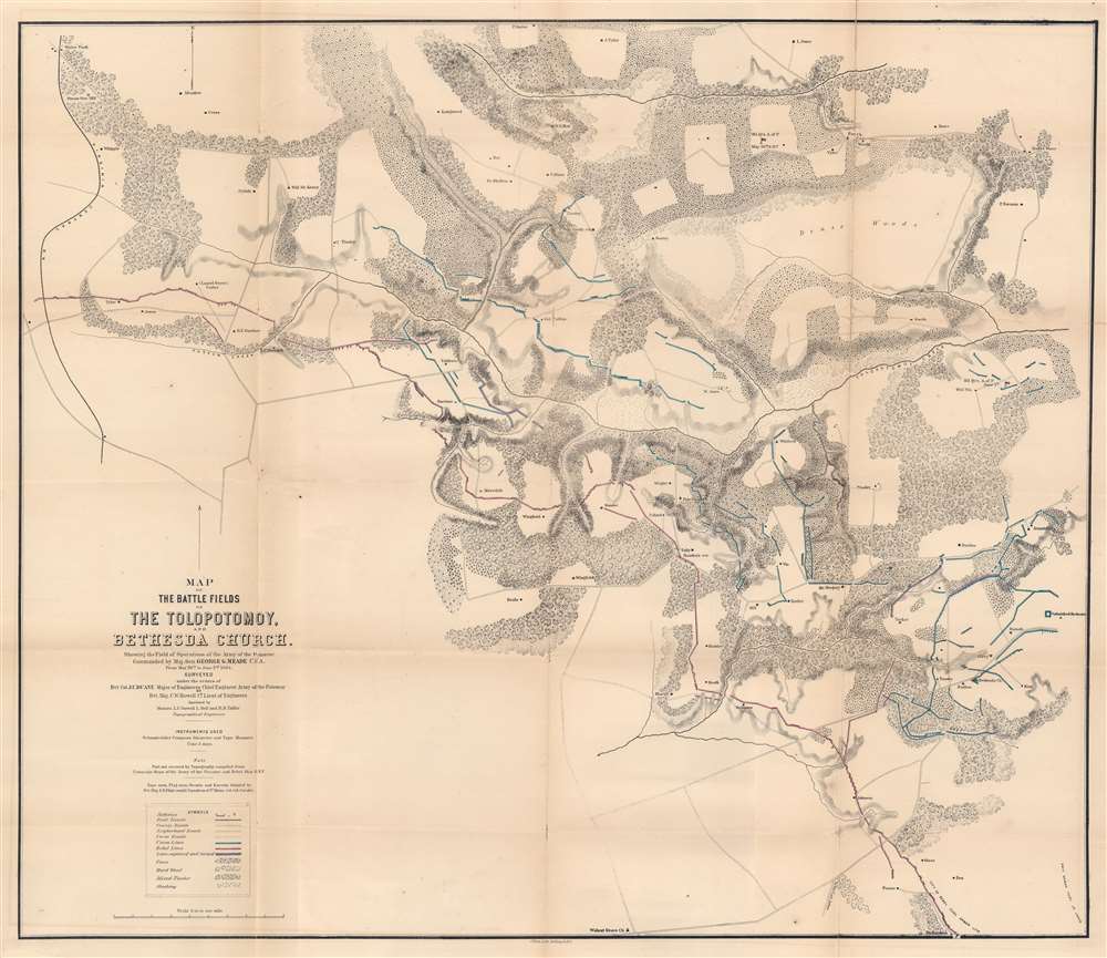
Map of the Battlefields of The Tolopotomoy and Bethesda Church Showing the Field of Operations of the Army of the Potomac Commanded by Maj. Gen. George G. Meade U.S. Army From May 28th to June 2nd 1864.
1864 (dated) 24.5 x 28.5 in (62.23 x 72.39 cm) 1 : 15840
1864 (dated) 24.5 x 28.5 in (62.23 x 72.39 cm) 1 : 15840
Description
This is an 1864 Charles W. Howell and James C. Duane map of the battle of Totopotomoy Creek, fought during the American Civil War (1861 - 1865). Depicting the battlefield and the immediate surroundings, red highlights Confederate lines while blue emphasizes Union positions. Red and blue lines illustrate Confederate positions captured by the Union. Army of the Potomac headquarters throughout the battle are labeled and marked with a small American flag. Homesteads in the region, the local store, and churches are identified by name.
The Battle of Totopotomoy Creek
The Battle of Totopotomoy Creek (also known as the Battle of Bethesda Church) was part of Union Lieutenant General Ulysses S. Grant's Overland Campaign, fought in Hanover County, Virginia from May 28 - 30, 1864. As was the case with many of the battles during the Overland Campaign, Grant's Army of the Potomac and General Robert E. Lee's Army of Northern Virginia fought to a bloody standstill at Totopotomoy Creek. No advantage was gained by either side, although at Totopotomoy Creek the Confederates suffered higher casualties than Union forces. After several failed assaults on Confederate lines, General Grant continued moving his troops to the south, toward the disastrous Union defeat at the Battle of Cold Harbor.Publication History and Census
This map was created by Charles Wagoner Howell with assistance from L.C. Oswell, L. Bell, and R.B. Talfor under orders from James C. Duane and printed by Julius Bien. We note eight examples cataloged in OCLC: New York Public Library, Harvard University, the Library of Congress, Pennsylvania State University, the Cincinnati History Library, the Wisconsin Historical Society, the University of California Los Angeles, and the British Library.CartographerS
Charles Wagoner Howell (July 21, 1841 - April 5, 1882) was a U.S. Army engineer and veteran of the American Civil War. Born in Goshen, Indiana, Howell entered West Point on September 1, 1859, and graduated seventh in his class of twenty-five on June 11, 1863. He was commissioned as a First Lieutenant on his graduation day and assigned to the Engineer Battalion of the Army of the Potomac, then engaged in the Pennsylvania Campaign. Per the obituary in the New Orleans Times-Picayune, his first important work as part of the Army of the Potomac was building a bridge across the Potomac at Berlin, Maryland. He served with the Army of the Potomac for the rest of the Civil War, serving in the Rapidan campaign, the Rappahannock campaign, the Mine Run operations, and General Grant's Overland Campaign. He was at Cold Harbor and the siege of Petersburg from June 17, 1864, until February 16, 1865. He was brevetted to captain and major during the siege of Petersburg. He also participated in the pursuit of the Confederate Army from Petersburg and was at Appomattox Court House for the surrender. After the war, he was transferred to Willett's Point, New York, where he was promoted to full Captain of Engineers on July 10, 1866. He was promoted to Major on June 30, 1879. He was ordered to New Orleans, Louisiana, on May 8, 1869, to take charge of the improvements of the mouth of the Mississippi River and the defenses of New Orleans. Not long after improving Galveston Harbor was added to his list of tasks. He died of consumption in New Orleans on April 5, 1882, after six months sick leave from the Army. According to the Times-Picayune obituary, 'Major Howell was a noble hearted, genial man, loved by all who knew him'. More by this mapmaker...
James Chatham Duane (June 10, 1824 - December 8, 1897) was an American engineer and U.S. Army officer. Born in Schenectady, New York, Duane graduated from Union College in 1884 and then attended the United States Military Academy at West Point and graduated third in his class in 1848. From 1852 through 1854, Duane taught practical military engineering at West Point. He commanded a select group of engineer troops that guarded President Abraham Lincoln at his 1861 inauguration. In 1862 at the Battle of Harpers Ferry Duane built the first military pontoon bridge of the Potomac River and served as Chief Engineer of the Army of the Potomac from 1863 until 1865. He commanded at Williets Point, New York, from 1866 through 1868 and constructed fortifications along the Maine and New Hampshire coasts from 1868 until 1878. He served as president of the Board of Engineers from 1884 through 1886. On October 11, 1886, he was appointed brigadier general and Chief of Engineers and retired on June 30, 1888. After retiring he became Commissioner of the Croton Aqueduct in New York City. In 1850 he married Harriet Whitehorne Brewerton (1839 - 1914) with whom he had three children. He died in New York City. Learn More...
Julius (Julien) Bien (September 27, 1826 - December 21, 1909) was a German-Jewish lithographer and engraver based in New York City. Bien was born in Naumburg, Germany. He was educated at the Academy of Fine Arts, Cassell and at Städel's Institute, Frankfurt-am-Main. Following the suppression of the anti-autocratic German Revolutions of 1848, Bien, who participated in the pan-German movement, found himself out of favor in his home country and joined the mass German immigration to the United States. Bien can be found in New York as early as 1849. He established the New York Lithographing, Engraving & Printing Company in New York that focused on the emergent chromo-lithograph process - a method of printing color using lithographic plates. His work drew the attention of the U.S. Government Printing Office which contracted him to produce countless government maps and surveys, including the Pacific Railroad Surveys, the census, numerous coast surveys, and various maps relating to the American Civil War. Bien also issued several atlases both privately and in conjunction with a relation, Joseph Bien. At the height of his career Bien was elected president of the American Lithographers Association. After his death in 1909, Bien's firm was taken over by his son who promptly ran it into insolvency. The firm was sold to Sheldon Franklin, who, as part of the deal, retained the right to publish under the Julius Bien imprint. In addition to his work as a printer, Bien was active in the New York German Jewish community. He was director of the New York Hebrew Technical Institute, the New York Hebrew Orphan Asylum, and president of the B'nai B'rith Order. Learn More...
Condition
Good. Wear along original fold lines. Verso repairs to fold separations. Old tape repairs evident on verso. Closed margin tears professionally repaired on verso. Minor loss at some fold intersections.