1862 J. Calvin Smith and Colton Folding Wall Map of the United States
UnitedStates-smithcolton-1862$7,500.00
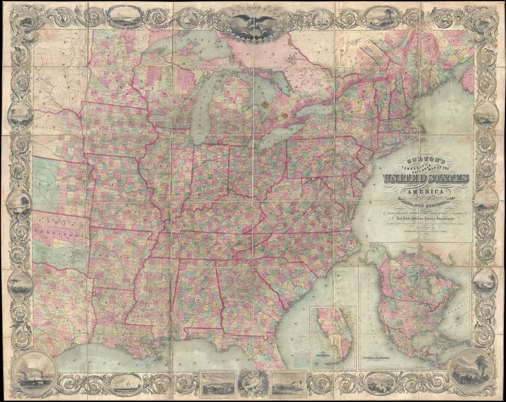

Title
Map of the United States of America Including Canada, and a large portion of Texas, Showing Base Meridian and Township Lines of the U.S. Surveys, Including Lands alotted to the Indian Tribes west of the Mississippi, The various internal improvements.
1862 (dated0 83 x 66 in (210.82 x 167.64 cm) 1 : 1500000
1862 (dated0 83 x 66 in (210.82 x 167.64 cm) 1 : 1500000
Description
One of the most striking American large format wall maps ever issued. This is the 1862 American Civil War era case map of the United States by J. Calvin Smith and updated by J. H. Colton. The map covers from Austin Texas to the eastern seaboard and from Lake Superior to the Gulf of Mexico. Smith first introduced this map in 1843 buy the present much revised and updated example is the 1862 Civil War Colton edition. When it was introduced in 1843, this map was hailed as the largest, best, and most detailed map of the United States yet published.
Smith's Promotional
Smith's 1847 promotional for the map advertises it asThe largest and most complete Map of the United States ever published, being about six feet by seven, showing the base, meridian, and Township lines of the United States Surveys, the land allotted to the different Indian tribes west of the Mississippi river …. The above work obtained the premium, a silver medal, at the late Fair of the American Institute, New-York, as the best and most accurate specimen of Map engraving.The map indeed remains one of the largest and most attractive American commercial maps to appear in the 19th century.
The Insets
There are two inset maps in the lower right quadrant of southern Florida and North America. The southern Florida map identifies Miami and attempts to illustrate speculative islands in the Everglades. The North America Map covers all of North America in the Civil War Era configuration with New Mexico and Arizona Territories divided on the horizontal, and an enormous Nebraska Territory stretching to Canada. In Utah, 'Mormon Settlement' at the site of modern-day Salt Lake City, but Fillmore City is identified as the capital. In California, the Gold Region is noted near the Sacramento River.Incredible Decorative Border
Of particular note is the map's impressive decorative boarder in which acanthus leaves embrace countless vignettes of American flora and fauna, American Indians, important cities, monuments, and more. At the top of the map a large eagle gripping the shield of the United States surrounded by 26 stars, each representing a state and containing a vignette. Four additional stars, which are partially shaded, include Iowa, Wisconsin, Texas, and another unidentifiable possible state.Publication History
Smith first issued this map in 1843 in partnership with George E. Sherman, possibly as an optional accompaniment to D. Haskel and J. Calvin Smith's A complete descriptive and statistical gazetteer of the United States of America. It was also sold independently both as a folding map and as a wall map mounted on rollers. Smith reissued the map with various minor updates until 1853, when the map plates were acquired by J. H. Colton. Colton, wanting the most up to date map possible to reflect the rapid changes of the Civil War Era, complete extensive revisions to the map's geographical content, retaining the borders and overall composition. The map retains both the 1843 Smith copyright and has the renewed 1862 Colton copyright. All examples are rare.CartographerS
John Calvin Smith (1809 – June 11, 1890) was an American surveyor and geographer active in New York during the middle part of the 19th century. He was a charter member of the American Geographical and Statistical Society (American Geographical Society). He worked with other important New York cartographers including John Disturnell, George Sherman, and Samuel Stiles, with whom he often published under the Stiles, Sherman & Smith imprint. Stiles may have introduced Smith to J. H. Colton, who acquired many of his map plates in 1853. Most of Smith's maps focus on New York counties, but he also issued maps of the United States, Illinois, Texas, and the California gold fields. Despite being an important and prolific cartographer, much of his personal life and history are shrouded in mystery. More by this mapmaker...
Joseph Hutchins Colton (July 5, 1800 - July 29, 1893), often publishing as J. H. Colton, was an important American map and atlas publisher active from 1833 to 1897. Colton's firm arose from humble beginnings when he moved to New York in 1831 and befriended the established engraver, Samuel Stiles. He worked under Stiles as the 'Co.' in Stiles and Co. from 1833 to 1836. Colton quickly recognized an emerging market in railroad maps and immigrant guides. Not a cartographer or engraver himself, Colton's initial business practice mostly involved purchasing the copyrights of other cartographers, most notably David H. Burr, and reissuing them with updated engraving and border work. His first maps, produced in 1833, were based on earlier Burr maps and depicted New York State and New York City. Between 1833 and 1855, Colton proceeded to publish a large corpus of guidebooks and railroad maps, which proved popular. In the early 1850s, Colton brought his two sons, George Woolworth Colton (1827 - 1901) and Charles B. Colton (1832 - 1916), into the map business. G. W. Colton, trained as a cartographer and engraver, was particularly inspired by the idea of creating a large and detailed world atlas to compete with established European firms for the U.S. market. In 1855, G.W. Colton issued volume one of the impressive two-volume Colton's Atlas of the World. Volume two followed a year later. Possibly because of the expense of purchasing a two-volume atlas set, the sales of the Atlas of the World did not meet Colton's expectations, and so, in 1856, the firm also issued the atlas as a single volume. The maps contained in this superb work were all original engravings, and most bear an 1855 copyright. All of the maps were surrounded by an attractive spiral motif border that would become a hallmark of Colton's atlas maps well into the 1880s. In 1857, the slightly smaller Colton's General Atlas replaced the Atlas of the World. Most early editions of the General Atlas published from 1857 to 1859 do not have the trademark Colton spiral border, which was removed to allow the maps to fit into a smaller format volume. Their customers must have missed the border because it was reinstated in 1860 and remained in all subsequent publications of the atlas. There were also darker times ahead; in 1858, Colton was commissioned at a sum of 25,000 USD by the government of Bolivia to produce and deliver 10,000 copies of a large format map of that country. Although Colton completed the contract in good faith, delivering the maps at his own expense, he was never paid by Bolivia, which was at the time in the midst of a series of national revolutions. Colton would spend the remainder of his days fighting with the Bolivian and Peruvian governments over this payment, and in the end, after a congressional intervention, he received as much as 100,000 USD in compensation. Nonetheless, at the time, it was a disastrous blow. J. H. Colton and Company is listed as one of New York's failed companies in the postal record of 1859. This led Colton into the arms of Alvin Jewett Johnson and Ross C. Browning. The 1859 edition of Colton's General Atlas lists Johnson and Browning as the 'Successor's to J. H. Colton' suggesting an outright buyout, but given that both companies continued to publish separately, the reality is likely more complex. Whatever the case may have been, this arrangement gave Johnson and Browning access to many of Colton's map plates and gave birth to Johnson's New Illustrated (Steel Plate) Family Atlas. The Johnson's Atlas was published parallel to Colton's atlases well into the 1880s. The Colton firm itself subsequently published several other atlases including an Atlas of America, the Illustrated Cabinet Atlas, the Octavo Atlas of the Union, and Colton's Quarto Atlas of the World. They also published a large corpus of wall maps, pocket maps, and guides. The last known publications of the Colton firm date to 1897 and include a map and a view, both issued in association with the Merchant's Association of New York. Alice M. Colton married August R. Ohman (May 3, 1859 - April 22, 1934) on January 5, 1897. In 1898, Ohman joined the Colton firm, which continued to publish as Colton, Ohman & Co. until 1901. Learn More...
Sherman and Smith (fl. c. 1829 - 1855), sometimes working as Stiles, Sherman & Smith, were American engravers active in New York City during the middle part of the 19th century. The firm including John Calvin Smith (surveyor and engraver), George E. Sherman, and sometimes, Samuel Stiles. Their work primarily focused on government publications, including the maps and engravings prepared to illustrate the official records of the 1838-42 United States Exploring Expedition (U.S. Ex. Ex.), maps issued for the Army Corps of Topographical Engineers, and various U.S. Coast Survey Charts. They also engraved privately for Thomas Bradford and John Disturnell, among others. Sherman and Smith maintained offices at the corner of Broadway and Liberty Street in New York City and were highly regarded as the finest cartographic engravers in the city. Their non-cartographic legacies include George Inness, who apprenticed with them for two years before going on to become a well regarding American landscape painter of the Hudson River School. Learn More...
Condition
Very good. Map exhibits overall toning and soiling, but is otherwise in remarkable condition. Has original linen backing and edging, both stable. Accompanied by original gilt stamped binder.
References
Rumsey 2529.001. Phillips, P.L. (Maps) p.896. Wheat, Carl Irving, Mapping of the Transmississippi West, 1540-1861, 1471 (inset). . Ristow, W., American Maps and Mapmakers: Commercial Cartography in the Nineteenth Century, 318. OCLC 60688005, 41589181, 494980983.