Digital Image: 1831 Dien Celestial Map of the Stars and Constellations (Signed First Edition)
Uranographie-dien-1831_d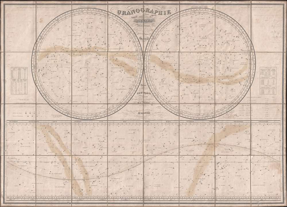

Title
Uranographie.
1831 (dated) 31.75 x 43.75 in (80.645 x 111.125 cm)
1831 (dated) 31.75 x 43.75 in (80.645 x 111.125 cm)
Description
FOR THE ORIGINAL ANTIQUE MAP, WITH HISTORICAL ANALYSIS, CLICK HERE.
Digital Map Information
Geographicus maintains an archive of high-resolution rare map scans. We scan our maps at 300 DPI or higher, with newer images being 600 DPI, (either TIFF or JPEG, depending on when the scan was done) which is most cases in suitable for enlargement and printing.
Delivery
Once you purchase our digital scan service, you will receive a download link via email - usually within seconds. Digital orders are delivered as ZIP files, an industry standard file compression protocol that any computer should be able to unpack. Some of our files are very large, and can take some time to download. Most files are saved into your computer's 'Downloads' folder. All delivery is electronic. No physical product is shipped.
Credit and Scope of Use
You can use your digial image any way you want! Our digital images are unrestricted by copyright and can be used, modified, and published freely. The textual description that accompanies the original antique map is not included in the sale of digital images and remains protected by copyright. That said, we put significant care and effort into scanning and editing these maps, and we’d appreciate a credit when possible. Should you wish to credit us, please use the following credit line:
Courtesy of Geographicus Rare Antique Maps (https://www.geographicus.com).
How Large Can I Print?
In general, at 300 DPI, you should at least be able to double the size of the actual image, more so with our 600 DPI images. So, if the original was 10 x 12 inches, you can print at 20 x 24 inches, without quality loss. If your display requirements can accommodate some loss in image quality, you can make it even larger. That being said, no quality of scan will allow you to blow up at 10 x 12 inch map to wall size without significant quality loss. For more information, it is best consult a printer or reprographics specialist.
Refunds
If the high resolution image you ordered is unavailable, we will fully refund your purchase. Otherwise, digital images scans are a service, not a tangible product, and cannot be returned or refunded once the download link is used.
Cartographer S
Charles Dien Jr. (February 9, 1800 - 1870) was a French cartographer, astronomer, engineer, and globe maker associated with the observatory of Paris. Dien inherited his map-publishing business from his father, Charles Dien Sr. He is the author of several books and manuals concerning the use of scientific instruments and was a frequent collaborator with Félix Delamarche. Dien was responsible for many improvements in globe making, as described by M. Charles Dupin,
M. Dien has made many improvements upon the paper globes in common use. He has rendered them much less hygrometric; he makes the meridian and the horizon in which the globe moves, of copper. These circles are moveable by means of wheel-work.More by this mapmaker...
Alexis Bouvard (June 27, 1767 - June 7, 1843) was a French astronomer. Born in Contamines-Montjoie, Bouvard, who came from a family with four other children, left for Paris on his own at the age of seventeen. Once in Paris, he found his was to the Bureau des longitudes and the Observatory of Paris, where he was became a student astronomer. Eventually, Bouvard was named the director of the Observatory of Paris. Among his achievements include the discovery of eight comets and the compilation of the astronomical tables for Jupiter, Saturn, and Uranus. While the first two tables were a complete success, the latter contained substantial discrepancies with calculations performed at other observatories. This led Bouvard to hypothesize the existence of an eighth planet which created the irregularities in Uranus' orbit. John Couch Adams and Urban Le Verrier would independently discover the planet Neptune by using calculations based on Bouvard's observations, though only after Bouvard had died. Learn More...
References
Linda Hall Library QB65.D526 1831. OCLC 19060870.