Digital Image: 1840 Blunt Nautical Map of West Florida, Louisiana, Mississippi
WestFlorida-blunt-1840_d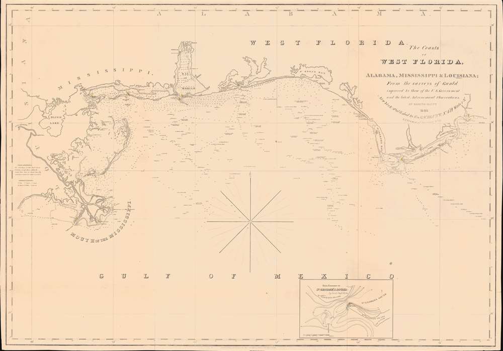


Title
The Coasts of West Florida, Alabama, Mississippi and Louisiana; From the surveys of Gauld improved by those of the U.S. Government and the latest Astronomical Observations.
1840 (dated) 26 x 37 in (66.04 x 93.98 cm) 1 : 680000
1840 (dated) 26 x 37 in (66.04 x 93.98 cm) 1 : 680000
Description
FOR THE ORIGINAL ANTIQUE MAP, WITH HISTORICAL ANALYSIS, CLICK HERE.
Digital Map Information
Geographicus maintains an archive of high-resolution rare map scans. We scan our maps at 300 DPI or higher, with newer images being 600 DPI, (either TIFF or JPEG, depending on when the scan was done) which is most cases in suitable for enlargement and printing.
Delivery
Once you purchase our digital scan service, you will receive a download link via email - usually within seconds. Digital orders are delivered as ZIP files, an industry standard file compression protocol that any computer should be able to unpack. Some of our files are very large, and can take some time to download. Most files are saved into your computer's 'Downloads' folder. All delivery is electronic. No physical product is shipped.
Credit and Scope of Use
You can use your digial image any way you want! Our digital images are unrestricted by copyright and can be used, modified, and published freely. The textual description that accompanies the original antique map is not included in the sale of digital images and remains protected by copyright. That said, we put significant care and effort into scanning and editing these maps, and we’d appreciate a credit when possible. Should you wish to credit us, please use the following credit line:
Courtesy of Geographicus Rare Antique Maps (https://www.geographicus.com).
How Large Can I Print?
In general, at 300 DPI, you should at least be able to double the size of the actual image, more so with our 600 DPI images. So, if the original was 10 x 12 inches, you can print at 20 x 24 inches, without quality loss. If your display requirements can accommodate some loss in image quality, you can make it even larger. That being said, no quality of scan will allow you to blow up at 10 x 12 inch map to wall size without significant quality loss. For more information, it is best consult a printer or reprographics specialist.
Refunds
If the high resolution image you ordered is unavailable, we will fully refund your purchase. Otherwise, digital images scans are a service, not a tangible product, and cannot be returned or refunded once the download link is used.
Cartographer S
Edmund March Blunt (June 20, 1770 - 1862) was an American navigator, bookseller, chartmaker, and cartographer based in Newburyport, Massachusetts. Blunt was born in Portsmouth, New Hampshire in 1770. In 1796, along with the nominal assistance of prominent navigator Captain Lawrence Furlong, Blunt published The American Coast Pilot, one of the most important published works on American navigation. Although much of the work was plagiarized from British publications, the Coast Pilot was an immediate popular success. In response to the popularity of his work, Blunt published 21 subsequent editions, each with important updates and revisions. The first edition to contain map plates was printed in 1804. Following a fire that destroyed his offices at The Sign of the Bible in 1811, Blunt moved his business to New York and opened a new shop, The Sign of the Quadrant. His sons Edmund Jr. (1799 - 1866) and George William (1802 - 1878), joined the firm in 1824 and eventually took over the family business, renaming the firm 'E. and G. W. Blunt'. They both produced their own nautical books, charts, and instruments, as well as republished their father’s work. In 1830, Edmund accepted a position under Ferdinand Hassler at the United States Office of the Coast Survey. Much of Blunt's original work eventually found its way into U.S. Coast Survey Publications. George closed the firm in 1872 and sold the plates and chart copyrights to the U.S. Coast Survey and the U.S. Navy Hydrographic Office. Due to the quality and detail of Blunt's work, revised editions of his most important charts were republished well into the 1880s. More by this mapmaker...
William Hooker (fl. c. 1811 - 1846) was an important American geographer, surveyor, and engraver active in New York during the early part of the 19th century. He is responsible for a number of important maps and geographies particularly focusing on the New York area. As a young man, Hooker may have been apprenticed to Edmund March Blunt, the well established publisher of the New England Coast Pilot. What is certain, is that in 1819, Hooker married Eliza Carleton, Blunt's daughter. He went on to publish a number of nautical charts, school geographies, guide books, and atlases in conjunction with Blunt and others, including Humphrey Phelps, Peabody & Company, and A. W. Wilgus. Hooker passed away in 1846. Learn More...
George Gauld (October 26, 1732 - June 8, 1782) was a Scottish surveyor, painter, and military engineer active in the mid to late 18th century. Gauld was born in Ardbrack, Banffshire, Scotland and educated at King's College, Aberdeen. He subsequently served in 1861 briefly on the HMS Deptford while it was testing John Harrison's revolutionary marine chronometer. He served in North America during the French and Indian War (1754 - 1763). In the immediate aftermath of the war, between 1764 and 1781, he was made Surveyor General of West Florida assigned to survey the coast. Gauld's survey efforts ended in 1781 when Spain besieged Pensacola and invaded West Florida, capturing him. It is not clear if his survey work found its way into Spanish hydrographic charts, but it may have been incorporated into general Direccion Hidrografía knowledge. Gauld was repatriated to England in 1782 and died shortly after. His survey work remained unpublished throughout the American Revolutionary War (1775 - 1783), when the valuable data might have fallen into rebel hands. It remained the best and most detailed survey of the Gulf Coast until the work of the U.S. Coast Survey in the 1840s. Learn More...
References
OCLC 55627589 (1828).