This item has been sold, but you can get on the Waitlist to be notified if another example becomes available, or purchase a digital scan.
1840 Blunt Nautical Map of West Florida, Louisiana, Mississippi
WestFlorida-blunt-1840$1,400.00


Title
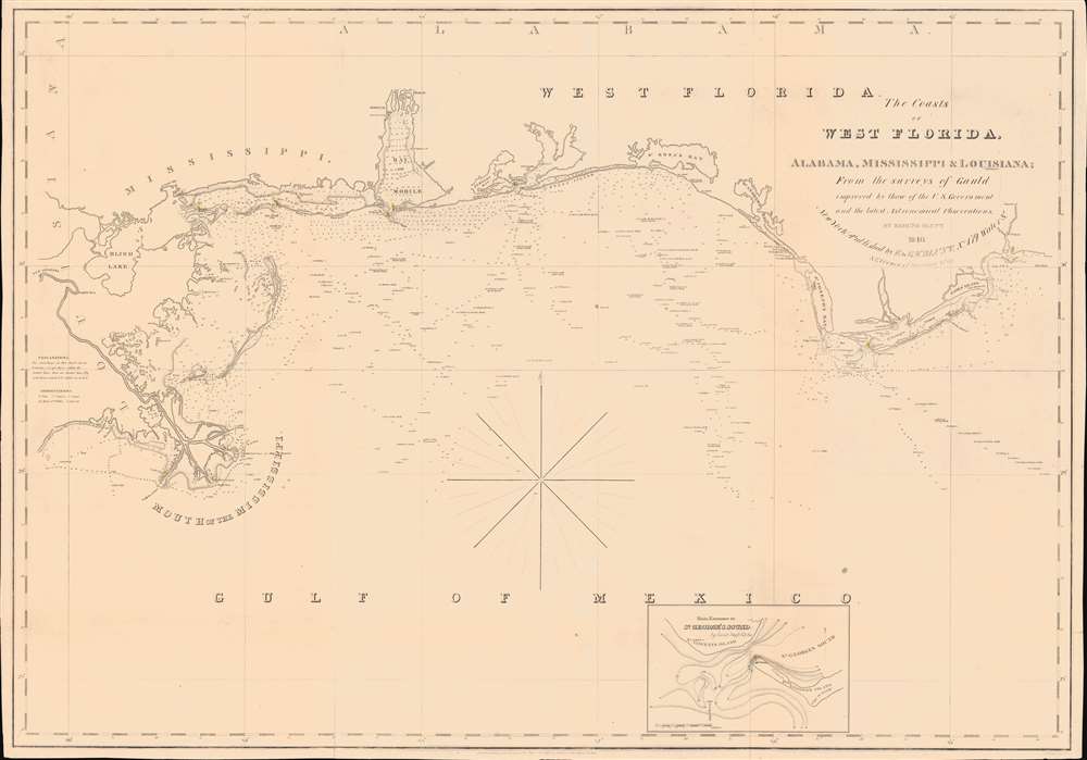
The Coasts of West Florida, Alabama, Mississippi and Louisiana; From the surveys of Gauld improved by those of the U.S. Government and the latest Astronomical Observations.
1840 (dated) 26 x 37 in (66.04 x 93.98 cm) 1 : 680000
1840 (dated) 26 x 37 in (66.04 x 93.98 cm) 1 : 680000
Description
A rare Edmund March Blunt 1840 nautical map of West Florida, embracing the Gulf Coast from the mouths of the Mississippi to the Saint Marks River. The survey is based upon the groundbreaking work of Scottish hydrographer George Gould following the French and Indian War (1754 - 1763). Despite being nearly seventy years old by the time this chart was published, it remained the definitive mapping of the Gulf Coast until after the American Civil War (1861 - 1865).
Blueback Charts
Blueback nautical charts began appearing in London in the late 18th century. Bluebacks, as they came to be called, were privately published large format nautical charts known for their distinctive blue paper backing. The backing, a commonly available blue manila paper traditionally used by publishers to wrap unbound pamphlets, was adopted as a practical way to reinforce the low-quality paper used by private chart publishers in an effort to cut costs. That being said, not all blueback charts are literally backed with blue paper. The earliest known blueback charts include a 1760 chart issued by Mount and Page, and a 1787 chart issued by Robert Sayer. The tradition took off in the early 19th century, when British publishers like John Hamilton Moore, Robert Blachford, James Imray, William Heather, John William Norie, Charles Wilson, David Steel, R. H. Laurie, and John Hobbs, among others, rose to dominate the chart trade. Bluebacks became so popular that the convention was embraced by chartmakers outside of England, including Americans Edmund March Blunt and George Eldridge, as well as Scandinavian, French, German, Russian, and Spanish chartmakers. Blueback charts remained popular until the late 19th century, when government subsidized organizations like the British Admiralty Hydrographic Office and the United States Coast Survey, began issuing their own superior charts on high quality paper that did not require reinforcement.Publication History and Census
This chart was engraved by William Hooker for Edmund March Blunt. It was first issued in 1828 as general replacement for his earlier chart of 1815, Chart of the Mississippi River and the Coast of West Florida, also a Gault derivative. It went through several subsequent editions, some of which we can identify only anecdotally, including 1831, 1834, 1837, 1839, and, as here, 1840. We are aware of no later editions. All editions are scarce, this being the only known example of the 1840 edition. Rumsey notes an example of the 1828 edition and in the OCLC, we see just one example (1838) at the Massachusetts Historical Society.CartographerS
Edmund March Blunt (June 20, 1770 - 1862) was an American navigator, bookseller, chartmaker, and cartographer based in Newburyport, Massachusetts. Blunt was born in Portsmouth, New Hampshire in 1770. In 1796, along with the nominal assistance of prominent navigator Captain Lawrence Furlong, Blunt published The American Coast Pilot, one of the most important published works on American navigation. Although much of the work was plagiarized from British publications, the Coast Pilot was an immediate popular success. In response to the popularity of his work, Blunt published 21 subsequent editions, each with important updates and revisions. The first edition to contain map plates was printed in 1804. Following a fire that destroyed his offices at The Sign of the Bible in 1811, Blunt moved his business to New York and opened a new shop, The Sign of the Quadrant. His sons Edmund Jr. (1799 - 1866) and George William (1802 - 1878), joined the firm in 1824 and eventually took over the family business, renaming the firm 'E. and G. W. Blunt'. They both produced their own nautical books, charts, and instruments, as well as republished their father’s work. In 1830, Edmund accepted a position under Ferdinand Hassler at the United States Office of the Coast Survey. Much of Blunt's original work eventually found its way into U.S. Coast Survey Publications. George closed the firm in 1872 and sold the plates and chart copyrights to the U.S. Coast Survey and the U.S. Navy Hydrographic Office. Due to the quality and detail of Blunt's work, revised editions of his most important charts were republished well into the 1880s. More by this mapmaker...
William Hooker (fl. c. 1811 - 1846) was an important American geographer, surveyor, and engraver active in New York during the early part of the 19th century. He is responsible for a number of important maps and geographies particularly focusing on the New York area. As a young man, Hooker may have been apprenticed to Edmund March Blunt, the well established publisher of the New England Coast Pilot. What is certain, is that in 1819, Hooker married Eliza Carleton, Blunt's daughter. He went on to publish a number of nautical charts, school geographies, guide books, and atlases in conjunction with Blunt and others, including Humphrey Phelps, Peabody & Company, and A. W. Wilgus. Hooker passed away in 1846. Learn More...
George Gauld (October 26, 1732 - June 8, 1782) was a Scottish surveyor, painter, and military engineer active in the mid to late 18th century. Gauld was born in Ardbrack, Banffshire, Scotland and educated at King's College, Aberdeen. He subsequently served in 1861 briefly on the HMS Deptford while it was testing John Harrison's revolutionary marine chronometer. He served in North America during the French and Indian War (1754 - 1763). In the immediate aftermath of the war, between 1764 and 1781, he was made Surveyor General of West Florida assigned to survey the coast. Gauld's survey efforts ended in 1781 when Spain besieged Pensacola and invaded West Florida, capturing him. It is not clear if his survey work found its way into Spanish hydrographic charts, but it may have been incorporated into general Direccion Hidrografía knowledge. Gauld was repatriated to England in 1782 and died shortly after. His survey work remained unpublished throughout the American Revolutionary War (1775 - 1783), when the valuable data might have fallen into rebel hands. It remained the best and most detailed survey of the Gulf Coast until the work of the U.S. Coast Survey in the 1840s. Learn More...
Condition
Good. Blueback. Some wear on old fold lines.
References
OCLC 55627589 (1828).