Digital Image: 1953 Nils Hansell Pictorial Map of New York: The Wonders of New York
WondersofNewYork-hansell-1953_d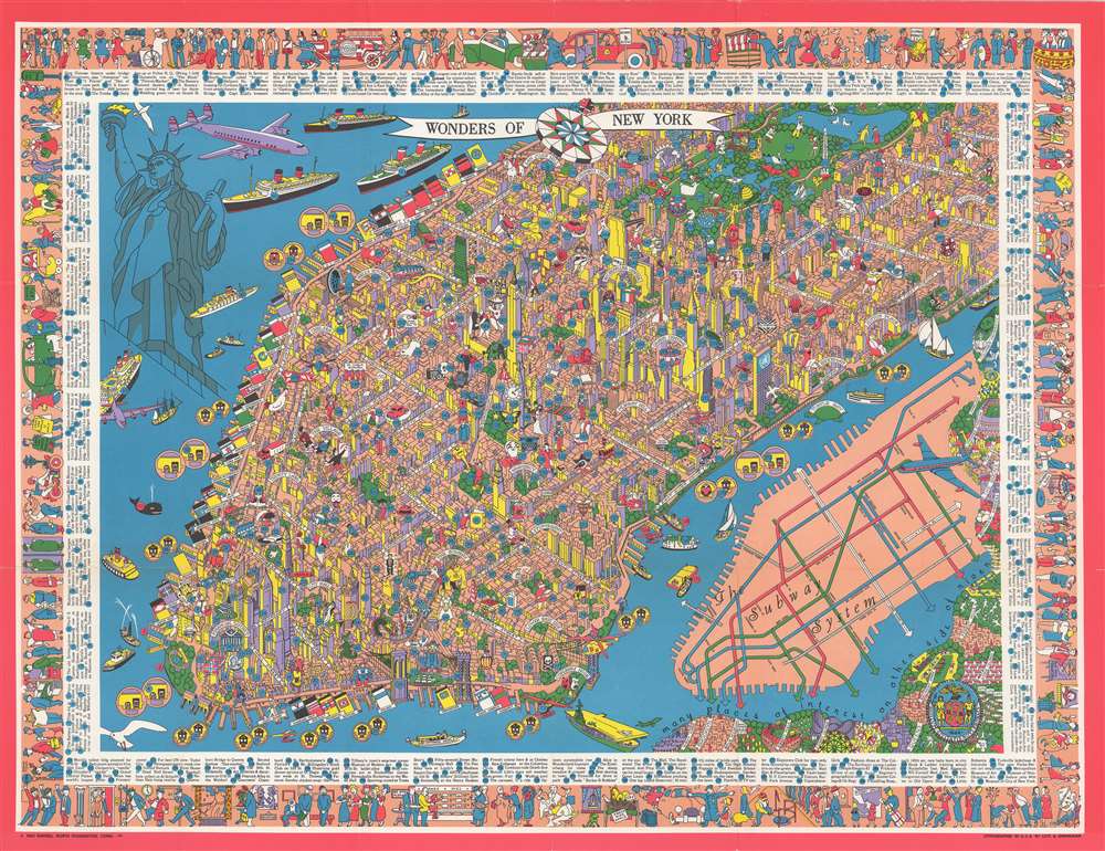

Title
Wonders of New York.
1953 (undated) 25.25 x 32.5 in (64.135 x 82.55 cm)
1953 (undated) 25.25 x 32.5 in (64.135 x 82.55 cm)
Description
FOR THE ORIGINAL ANTIQUE MAP, WITH HISTORICAL ANALYSIS, CLICK HERE.
Digital Map Information
Geographicus maintains an archive of high-resolution rare map scans. We scan our maps at 300 DPI or higher, with newer images being 600 DPI, (either TIFF or JPEG, depending on when the scan was done) which is most cases in suitable for enlargement and printing.
Delivery
Once you purchase our digital scan service, you will receive a download link via email - usually within seconds. Digital orders are delivered as ZIP files, an industry standard file compression protocol that any computer should be able to unpack. Some of our files are very large, and can take some time to download. Most files are saved into your computer's 'Downloads' folder. All delivery is electronic. No physical product is shipped.
Credit and Scope of Use
You can use your digial image any way you want! Our digital images are unrestricted by copyright and can be used, modified, and published freely. The textual description that accompanies the original antique map is not included in the sale of digital images and remains protected by copyright. That said, we put significant care and effort into scanning and editing these maps, and we’d appreciate a credit when possible. Should you wish to credit us, please use the following credit line:
Courtesy of Geographicus Rare Antique Maps (https://www.geographicus.com).
How Large Can I Print?
In general, at 300 DPI, you should at least be able to double the size of the actual image, more so with our 600 DPI images. So, if the original was 10 x 12 inches, you can print at 20 x 24 inches, without quality loss. If your display requirements can accommodate some loss in image quality, you can make it even larger. That being said, no quality of scan will allow you to blow up at 10 x 12 inch map to wall size without significant quality loss. For more information, it is best consult a printer or reprographics specialist.
Refunds
If the high resolution image you ordered is unavailable, we will fully refund your purchase. Otherwise, digital images scans are a service, not a tangible product, and cannot be returned or refunded once the download link is used.
Cartographer
Nils Birger Hansell (November 15, 1909 - January 6, 1989) was an American adventurer and illustrator active in the middle part of the 20h century. Hansell was born in Cadwell, New Jersey, the son of Swedish immigrants. The Hansell family initially lived on Waldo Avenue in the Bronx before moving to North Stonington , Connecticut, sometime after 1931. Hansell's mother, Ingeborg, designed sets and costume for the Greenwich Village Follies in the early 1920s and probably inspired his artistic flair. His father, Nils V. Hansell (1880 - 1980) was a mining engineer and oil executive, no doubt an influence that inspired a love of cartography. Hansell studied at the Fieldston Academy, an elite private school in the Bronx, after which he earned a place at the short-lived Great Books themed 'Experimental Collage' at the University of Wisconsin (1927 - 1932). Students of the 'Experimental Collage' quickly gained a reputation as free-spirited outsiders, with an uncanny tendency to love reading and learning in general. After graduating, he attended the Columbia graduate School of Journalism. In 1933 he accepted a position at the American Bankers' Association Journal. He quickly gained a reputation as a talented new journalist. Nonetheless, Hansell had a restless soul and wanted something different. He moved to Texas to start Hansell Transportation Company, running a fleet of tractor-trailers throughout the southwest. Shortly before World War II he sold the company, becoming in the process quite wealthy. He was drafted in the U.S. Army at the outbreak of the war and assigned to the Air Transport Command, where he served in North Africa, the Middle East, and India. After the war he traveled extensively in Europe and American, completing solo canoe voyages down the Danube and through the Erie Canal. Back in New York he worked as a graphic artist for IBM, as well as a freelancer, producing works for numerous publications. His cartographic corpus is limited but includes a quirky pictorial map of New York City issued in August of 1953. In addition to his design work, Nils pioneered Operation Sail, a regular international gathering of tall ships in New York Harbor. More by this mapmaker...
References
Rumsey 8982.000. OCLC 15288155. Hornsby, S. J., Picturing America: The Golden Age of Pictorial Maps, plate 155, page 260.