
This item below is out of stock, but another example (left) is available. To view the available item, click "Details."
Details
1953 Nils Hansell Pictorial Map of New York: The Wonders of New York
$2,250.00
1953 Nils Hansell Pictorial Map of New York: The Wonders of New York
WondersofNewYork-hansell-1953$750.00

Title
Wonders of New York.
1953 (undated) 25.25 x 32.5 in (64.135 x 82.55 cm)
1953 (undated) 25.25 x 32.5 in (64.135 x 82.55 cm)
Description
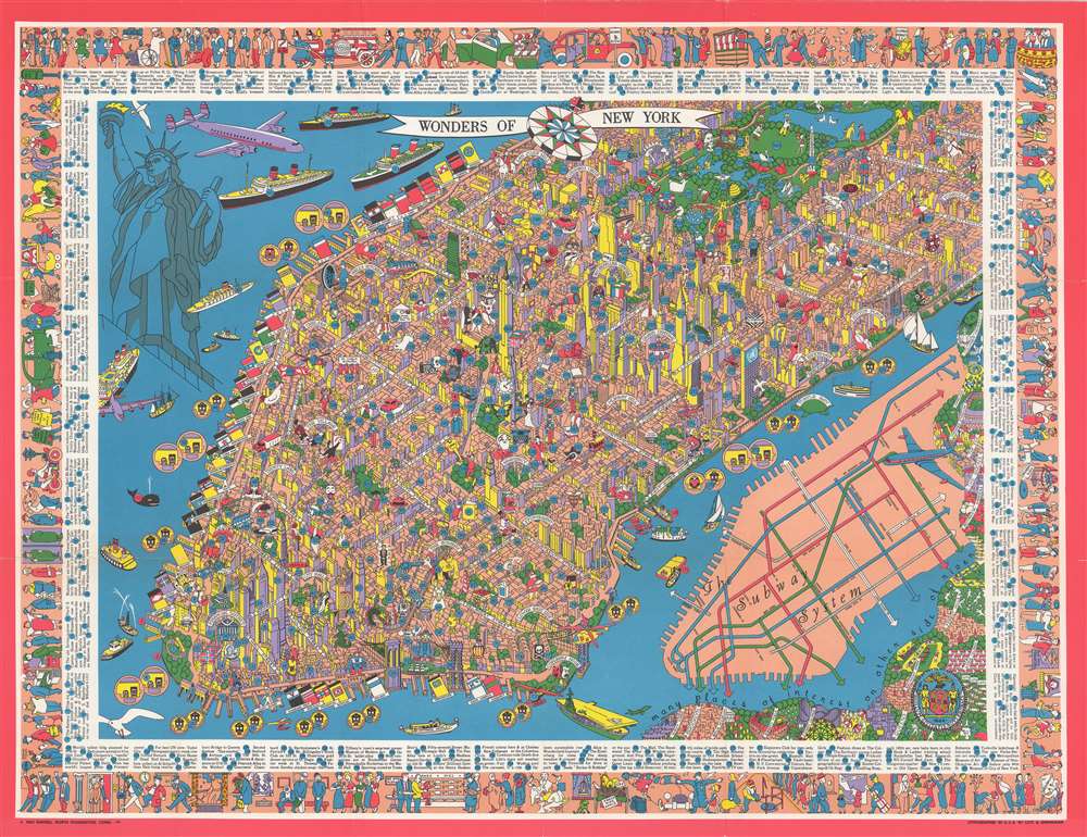
A production of the utmost weirdness, this is a fun-fact-filled dramatic 1953 pictorial map of New York City by the flamboyant Swedish-American artist, Nils Birger Hansell. Covering the Manhattan from roughly the Battery to 96th street, the map presents a scene of bustling modernity with a humorous twist. Nils illustrates the architectural and entertainment wonders, and general curiosities, of New York City, successfully evoking the city's inspiring creative spirit. The map was perhaps inspired by the work of Charles Vernon Farrow, who made a similar map of New York in 1927 entitled, A Map of the Wondrous Isle of Manhattan. While cartographically similar, Nils' map is far more playful and flamboyant. The map is surrounded by a whimsical pictorial order illustrating day-to-day life scenes from 1950 s New York. Some 301 sites, individuals, and events, are located throughout and referenced numerically.
A Deep Dive into the Quirks of New York
The cartography and annotations suggest a deep connection and knowledge of New York. Among other oddities, he notes a building where only beautiful redhaird women are hired to man the elevators (260 Madison, #179), the old Syrian Quarter (#9), the folklore location of the pirate Captain Kidd's buried treasure (#77), and Shinbone Alley (#96, home of the philosopher-cockroach 'Archy' and the 9th life street cat 'Mehitabel'), and notes obscure facts, such as the city code that allows Trinity Church to claim any whale caught in the Hudson River.Bowery Mose
Among the oddities, the map identifies 'Bowery Mose' or ' Mose the Fireboy,' a kind of New York Jewish-American Paul Bunyan who lived in the Lower East Side, worked as a fireman in Company 49, and apparently measured some 8ft in height He is credited with numerous of unlikely feats of strength and far-fetched escapades, among them deadlifting trolley cars and swimming the Hudson with 2 strokes. He legend is based upon Bowery Moses Humphrey, a New York grocer, printer, local tough, and member of the Bowery Boys. The Bowery Boys were a nativist, anti-Catholic, anti-Irish criminal gang who, among other eccentricates, enjoyed the theater.Ships of the Sea
Hansell loved maritime life and appropriately, the seas are full of large ocean liners, among them the Queen Elizabeth, the Liberté, the S. S. Constitution, the S. S. United States and the Oslofjord (perhaps a nod to Hansell's Scandinavian heritage?). The U.S.S. Midway aircraft carrier, the largest ship in the world until 1955, appears in the lower right.Publication History and Census
This map exists in only a single edition. It was published in 1953 by Nils Hansen and lithographed by Lutz and Shienkman. The map is today quite rare with the OCLC identifying only 4 examples in institutional collections. We are aware of one other example in the Rumsey Collection at Stanford.Cartographer
Nils Birger Hansell (November 15, 1909 - January 6, 1989) was an American adventurer and illustrator active in the middle part of the 20h century. Hansell was born in Cadwell, New Jersey, the son of Swedish immigrants. The Hansell family initially lived on Waldo Avenue in the Bronx before moving to North Stonington , Connecticut, sometime after 1931. Hansell's mother, Ingeborg, designed sets and costume for the Greenwich Village Follies in the early 1920s and probably inspired his artistic flair. His father, Nils V. Hansell (1880 - 1980) was a mining engineer and oil executive, no doubt an influence that inspired a love of cartography. Hansell studied at the Fieldston Academy, an elite private school in the Bronx, after which he earned a place at the short-lived Great Books themed 'Experimental Collage' at the University of Wisconsin (1927 - 1932). Students of the 'Experimental Collage' quickly gained a reputation as free-spirited outsiders, with an uncanny tendency to love reading and learning in general. After graduating, he attended the Columbia graduate School of Journalism. In 1933 he accepted a position at the American Bankers' Association Journal. He quickly gained a reputation as a talented new journalist. Nonetheless, Hansell had a restless soul and wanted something different. He moved to Texas to start Hansell Transportation Company, running a fleet of tractor-trailers throughout the southwest. Shortly before World War II he sold the company, becoming in the process quite wealthy. He was drafted in the U.S. Army at the outbreak of the war and assigned to the Air Transport Command, where he served in North Africa, the Middle East, and India. After the war he traveled extensively in Europe and American, completing solo canoe voyages down the Danube and through the Erie Canal. Back in New York he worked as a graphic artist for IBM, as well as a freelancer, producing works for numerous publications. His cartographic corpus is limited but includes a quirky pictorial map of New York City issued in August of 1953. In addition to his design work, Nils pioneered Operation Sail, a regular international gathering of tall ships in New York Harbor. More by this mapmaker...
Condition
Very good. Light wear on original fold lines.
References
Rumsey 8982.000. OCLC 15288155. Hornsby, S. J., Picturing America: The Golden Age of Pictorial Maps, plate 155, page 260.