Digital Image: 1548 Giacomo Gastaldi Map of the World
World-gastaldi-1548_d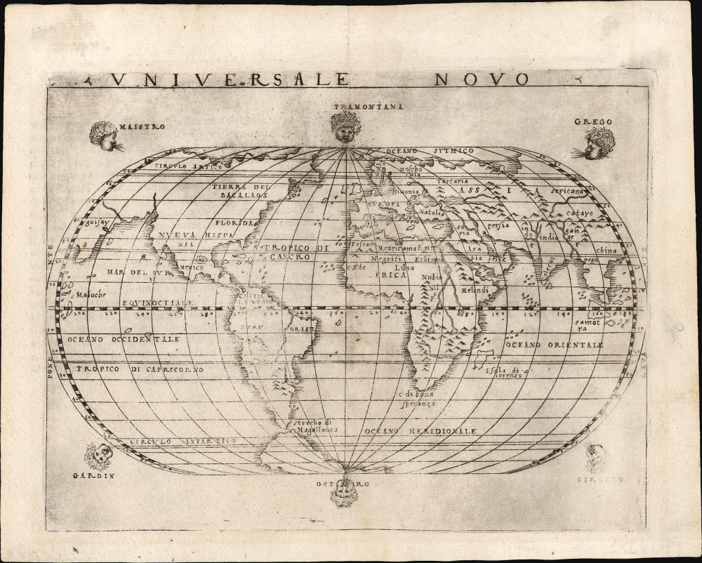


Title
Universale Novo.
1548 (undated) 5.25 x 6.75 in (13.335 x 17.145 cm) 1 : 1000000000
1548 (undated) 5.25 x 6.75 in (13.335 x 17.145 cm) 1 : 1000000000
Description
FOR THE ORIGINAL ANTIQUE MAP, WITH HISTORICAL ANALYSIS, CLICK HERE.
Digital Map Information
Geographicus maintains an archive of high-resolution rare map scans. We scan our maps at 300 DPI or higher, with newer images being 600 DPI, (either TIFF or JPEG, depending on when the scan was done) which is most cases in suitable for enlargement and printing.
Delivery
Once you purchase our digital scan service, you will receive a download link via email - usually within seconds. Digital orders are delivered as ZIP files, an industry standard file compression protocol that any computer should be able to unpack. Some of our files are very large, and can take some time to download. Most files are saved into your computer's 'Downloads' folder. All delivery is electronic. No physical product is shipped.
Credit and Scope of Use
You can use your digial image any way you want! Our digital images are unrestricted by copyright and can be used, modified, and published freely. The textual description that accompanies the original antique map is not included in the sale of digital images and remains protected by copyright. That said, we put significant care and effort into scanning and editing these maps, and we’d appreciate a credit when possible. Should you wish to credit us, please use the following credit line:
Courtesy of Geographicus Rare Antique Maps (https://www.geographicus.com).
How Large Can I Print?
In general, at 300 DPI, you should at least be able to double the size of the actual image, more so with our 600 DPI images. So, if the original was 10 x 12 inches, you can print at 20 x 24 inches, without quality loss. If your display requirements can accommodate some loss in image quality, you can make it even larger. That being said, no quality of scan will allow you to blow up at 10 x 12 inch map to wall size without significant quality loss. For more information, it is best consult a printer or reprographics specialist.
Refunds
If the high resolution image you ordered is unavailable, we will fully refund your purchase. Otherwise, digital images scans are a service, not a tangible product, and cannot be returned or refunded once the download link is used.
Cartographer
Giacomo Gastaldi (c. 1500 - October, 1566) was an Italian astronomer, cartographer, and engineer active in the second half of the 16th century. Gastaldi (sometimes referred to as Jacopo or Iacobo) began his career as an engineer, serving the Venetian Republic in that capacity until the fourth decade of the sixteenth century. During this time he traveled extensively, building a large library relating to voyages and exploration. From about 1544 he turned his attention to mapmaking, working extensively with Gextantiovanni Battista Ramusio, Nicolo Bascarini, and Giovanbattista Pedrezano, as well as taking private commissions for, among others, Venice's Council of Ten. He is credited with the fresco maps of Asia and Africa still extant in the map room of the Doge's Palace. Gastaldi was also one of the first cartographers to embrace copper plate over woodblock engraving, marking an important development in the history of cartography. His 1548 edition of Ptolemy's Geographia was the first to be printed in a vernacular; it was the first to be printed in copperplate. As with his Swiss/German contemporary Münster, Gastaldi's work contained many maps depicting newly discovered regions for the first time, including the first map to focus on the East Coast of North America, and the first modern map of the Indian Peninsula. His works provided the source for the vast majority of the Venetian and Roman map publishers of the 1560s and 70s, and would continue to provide an outsize influence on the early maps of Ortelius, De Jode, and Mercator. More by this mapmaker...
Source
Gastaldi, G., La Geografia Di Claudio Ptolemeo Alessandrino, (Venice: Pedrezano) 1548.
Giacomo Gastaldi's 1548 La Geografia was one of the most important early editions of Claudius Ptolemy's foundational geographical work. It was the first small-format, portable edition of a Ptolemy, and the first of the 16th century to be executed with copperplate maps. It was the most complete, modernized, edition of Ptolemy yet attempted, with 34 tabulae modernae included to correspond with the classic 26 Ptolemaic maps. Of the first Ptolemies, Gastaldi's 1548 work was the first to include separate regional maps of the Americas, most notably a map of the American east coast derived from the explorations of Verrazzano and Cartier. Perhaps most importantly, Gastaldi's Ptolemy was the first to be published in a vernacular language, Italian. This work is a testament to the humanist correspondence of the 16th century: many of the modern maps were derived from those of the German-Swiss geographer Sebastian Münster, who provided Gastaldi with commentary in the text of the new translation as well. Although Gastaldi's Ptolemy would only be published in one edition, it provided the basis for Girolamo Ruscelli's editions beginning in 1561.
References
OCLC 215536676. Shirley, R., The Mapping of the World, 87.