This item has been sold, but you can get on the Waitlist to be notified if another example becomes available, or purchase a digital scan.
1548 Giacomo Gastaldi Map of the World
World-gastaldi-1548$2,125.00


Title
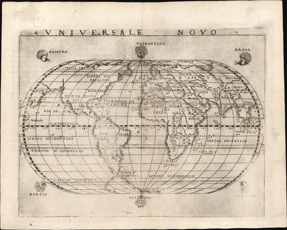
Universale Novo.
1548 (undated) 5.25 x 6.75 in (13.335 x 17.145 cm) 1 : 1000000000
1548 (undated) 5.25 x 6.75 in (13.335 x 17.145 cm) 1 : 1000000000
Description
This is Giacomo Gastaldi's 1548 Universale Novo, one of the earliest modern depictions of the world and the earliest acquirable world map from this pillar of Italian geography. It is also the earliest acquirable Italian map to show the full continent of America. It appeared in Gastaldi's edition of Ptolemy's Geographia, the first such to appear in the vernacular.
A Closer Look
This map presents the world on an oval projection; its orientation is indicated by six wind-heads placed about the map. Latitude and longitude are marked, as are the tropics, the Equator, and the Arctic and Antarctic circles. The delineation of the continents, consistent with Gastaldi's unobtainable 1546 map, presents a largely recognizable, contemporary formulation for the continents: Africa is circumnavigable and essentially correct in shape, albeit exhibiting that era's bafflement with the interior. Placenames are modern, though sparing, due to the small size of the map. The American coastline is well-realized; the Florida peninsula is recognizable; in Mexico, the capital's distinctive lagoon appears with much exaggeration, and Mexico City it is the only American city depicted. Baja California can be spotted on the west coast. In South America, the La Plata River is present, and a proto-Amazon River runs sharply south. Beyond the Strait of Magellan, Tierra del Fuego is presented as an extensive land mass encompassing the South Pole. In the Arctic, an 'Oceano Sythico' presents a possible northeast passage above Asia, while there is no similar possibility presented in North America.Asia Meets North America
As with all of his maps until 1561, Gastaldi's map presents an unambiguous continuity between America and China. The North American Pacific Coast extends west and south to the edge of the map where Quisay (Quinsai), Marco Polo's appellation for Hangzhou, is named.Publication History and Census
This map was engraved for inclusion in Gastaldi's 1548 Ptolemy. Nordenskiöld proposed that Gastaldi engraved the plates himself. The 1548 Ptolemy was printed in only one edition. The book is well-represented in institutional collections. The separate map appears on the market from time to time but appears to be cataloged only by the British Library and the National Library of Australia.Cartographer
Giacomo Gastaldi (c. 1500 - October, 1566) was an Italian astronomer, cartographer, and engineer active in the second half of the 16th century. Gastaldi (sometimes referred to as Jacopo or Iacobo) began his career as an engineer, serving the Venetian Republic in that capacity until the fourth decade of the sixteenth century. During this time he traveled extensively, building a large library relating to voyages and exploration. From about 1544 he turned his attention to mapmaking, working extensively with Gextantiovanni Battista Ramusio, Nicolo Bascarini, and Giovanbattista Pedrezano, as well as taking private commissions for, among others, Venice's Council of Ten. He is credited with the fresco maps of Asia and Africa still extant in the map room of the Doge's Palace. Gastaldi was also one of the first cartographers to embrace copper plate over woodblock engraving, marking an important development in the history of cartography. His 1548 edition of Ptolemy's Geographia was the first to be printed in a vernacular; it was the first to be printed in copperplate. As with his Swiss/German contemporary Münster, Gastaldi's work contained many maps depicting newly discovered regions for the first time, including the first map to focus on the East Coast of North America, and the first modern map of the Indian Peninsula. His works provided the source for the vast majority of the Venetian and Roman map publishers of the 1560s and 70s, and would continue to provide an outsize influence on the early maps of Ortelius, De Jode, and Mercator. More by this mapmaker...
Source
Gastaldi, G., La Geografia Di Claudio Ptolemeo Alessandrino, (Venice: Pedrezano) 1548.
Giacomo Gastaldi's 1548 La Geografia was one of the most important early editions of Claudius Ptolemy's foundational geographical work. It was the first small-format, portable edition of a Ptolemy, and the first of the 16th century to be executed with copperplate maps. It was the most complete, modernized, edition of Ptolemy yet attempted, with 34 tabulae modernae included to correspond with the classic 26 Ptolemaic maps. Of the first Ptolemies, Gastaldi's 1548 work was the first to include separate regional maps of the Americas, most notably a map of the American east coast derived from the explorations of Verrazzano and Cartier. Perhaps most importantly, Gastaldi's Ptolemy was the first to be published in a vernacular language, Italian. This work is a testament to the humanist correspondence of the 16th century: many of the modern maps were derived from those of the German-Swiss geographer Sebastian Münster, who provided Gastaldi with commentary in the text of the new translation as well. Although Gastaldi's Ptolemy would only be published in one edition, it provided the basis for Girolamo Ruscelli's editions beginning in 1561.
Condition
Very good. Strike soft in lower right, else excellent with generous margins.
References
OCLC 215536676. Shirley, R., The Mapping of the World, 87.