Digital Image: 1932 Julius Muller Map of Wyoming and the State's Highways
Wyoming-muller-1932_d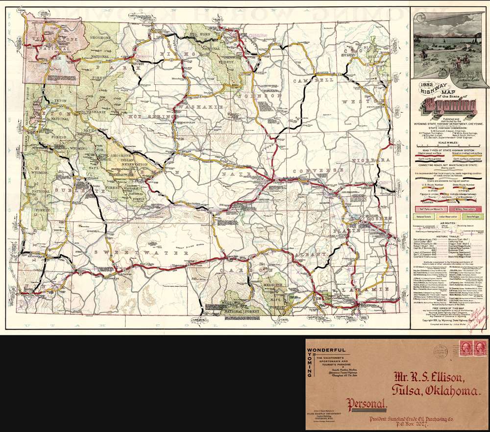

Title
1932 Highway Map of the State of Wyoming.
1932 (dated) 19.25 x 28.75 in (48.895 x 73.025 cm) 1 : 1020000
1932 (dated) 19.25 x 28.75 in (48.895 x 73.025 cm) 1 : 1020000
Description
FOR THE ORIGINAL ANTIQUE MAP, WITH HISTORICAL ANALYSIS, CLICK HERE.
Digital Map Information
Geographicus maintains an archive of high-resolution rare map scans. We scan our maps at 300 DPI or higher, with newer images being 600 DPI, (either TIFF or JPEG, depending on when the scan was done) which is most cases in suitable for enlargement and printing.
Delivery
Once you purchase our digital scan service, you will receive a download link via email - usually within seconds. Digital orders are delivered as ZIP files, an industry standard file compression protocol that any computer should be able to unpack. Some of our files are very large, and can take some time to download. Most files are saved into your computer's 'Downloads' folder. All delivery is electronic. No physical product is shipped.
Credit and Scope of Use
You can use your digial image any way you want! Our digital images are unrestricted by copyright and can be used, modified, and published freely. The textual description that accompanies the original antique map is not included in the sale of digital images and remains protected by copyright. That said, we put significant care and effort into scanning and editing these maps, and we’d appreciate a credit when possible. Should you wish to credit us, please use the following credit line:
Courtesy of Geographicus Rare Antique Maps (https://www.geographicus.com).
How Large Can I Print?
In general, at 300 DPI, you should at least be able to double the size of the actual image, more so with our 600 DPI images. So, if the original was 10 x 12 inches, you can print at 20 x 24 inches, without quality loss. If your display requirements can accommodate some loss in image quality, you can make it even larger. That being said, no quality of scan will allow you to blow up at 10 x 12 inch map to wall size without significant quality loss. For more information, it is best consult a printer or reprographics specialist.
Refunds
If the high resolution image you ordered is unavailable, we will fully refund your purchase. Otherwise, digital images scans are a service, not a tangible product, and cannot be returned or refunded once the download link is used.
Cartographer
Julius Muller (March 20, 1875 - December 12, 1948) was a Jewish German-American businessman, draftsman, surveyor, and civil engineer. Muller was born in Altonkunstad, Germany but by 1889, at roughly 14, he had emigrated to the United States. It is unclear where in the United States he lived until about 1897, when his is documented in Leadville, Colorado. He was naturalized a U.S. Citizen on year later in 1898. In 1899, he became a clerk for the Jewish Clothier Freedheim Brothers. In 1900 he became a clerk for Baer Brothers Mercantile, a Jewish cigar and liquor merchant. He remained with Baer Bothers until about 1910, when he succeeded into the ownership of said firm, renamed Muller Co. He became quite successful seller beer and spirits and even joined the 'Gentleman Driving Club', competing in several races. When Leadville turned into a dry town, well before national Prohibition, Muller relocated to Denver, and by 1919, to Casper, Wyoming. In Wyoming he worked as. A Civil Engineer, although it is unclear where he received he straining. He remained as a Civili Engineer in Wyoming until his retirement in the mid 1930s. He was employed with the Wyoming highway department and public survey office, and lived the remainder of his life in Casper and Cheyenne. In 1932 he produced the first official highway map of the State of Wyoming. Muller is also the author of The ABC of American Defense, and was known as an expert marksman and talented clarinetist. He died in Cheyenne, Wyoming and was survived bu a daughter. Mildred H. Eakin. More by this mapmaker...
References
OCLC 934439059.