Digital Image: 1906 War Office Folding Map of Yunnan Province, China
Yunnan-waroffice-1906_d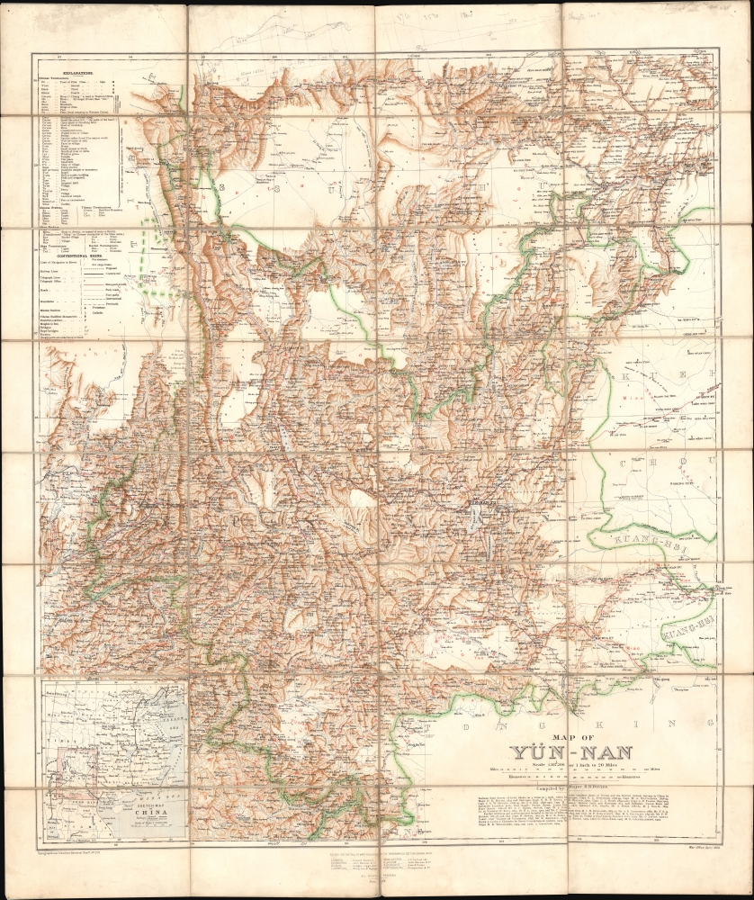


Title
Map of Yün-nan. Topographical Section General Staff, No. 2112.
1906 (dated) 37.5 x 31.75 in (95.25 x 80.645 cm) 1 : 1267200
1906 (dated) 37.5 x 31.75 in (95.25 x 80.645 cm) 1 : 1267200
Description
FOR THE ORIGINAL ANTIQUE MAP, WITH HISTORICAL ANALYSIS, CLICK HERE.
Digital Map Information
Geographicus maintains an archive of high-resolution rare map scans. We scan our maps at 300 DPI or higher, with newer images being 600 DPI, (either TIFF or JPEG, depending on when the scan was done) which is most cases in suitable for enlargement and printing.
Delivery
Once you purchase our digital scan service, you will receive a download link via email - usually within seconds. Digital orders are delivered as ZIP files, an industry standard file compression protocol that any computer should be able to unpack. Some of our files are very large, and can take some time to download. Most files are saved into your computer's 'Downloads' folder. All delivery is electronic. No physical product is shipped.
Credit and Scope of Use
You can use your digial image any way you want! Our digital images are unrestricted by copyright and can be used, modified, and published freely. The textual description that accompanies the original antique map is not included in the sale of digital images and remains protected by copyright. That said, we put significant care and effort into scanning and editing these maps, and we’d appreciate a credit when possible. Should you wish to credit us, please use the following credit line:
Courtesy of Geographicus Rare Antique Maps (https://www.geographicus.com).
How Large Can I Print?
In general, at 300 DPI, you should at least be able to double the size of the actual image, more so with our 600 DPI images. So, if the original was 10 x 12 inches, you can print at 20 x 24 inches, without quality loss. If your display requirements can accommodate some loss in image quality, you can make it even larger. That being said, no quality of scan will allow you to blow up at 10 x 12 inch map to wall size without significant quality loss. For more information, it is best consult a printer or reprographics specialist.
Refunds
If the high resolution image you ordered is unavailable, we will fully refund your purchase. Otherwise, digital images scans are a service, not a tangible product, and cannot be returned or refunded once the download link is used.
Cartographer S
Henry Rodolph Davies (September 21, 1865 - January 4, 1950) was a British military officer, rising to the rank of major general, who was a brigade and division commander in the First World War. Born in Windsor, Berkshire, Davies' father had also been an army officer (reaching lieutenant general) and his grandfather had been an admiral in the Royal Navy; his brother Francis was also a division commander in the First World War. H. R. Davies attended Eton College, where he studied Oriental Languages among other topics, which were useful in his later travels as a military officer. He attended the Royal Military College at Sandhurst and then was sent to Burma in 1887, and would remain in East Asia for more than a decade (in the process marrying a Burmese woman, with whom he had four children). In 1893, he joined a survey to map the mountain passes between Burma and China, then continued on to Yunnan to survey a potential railway route from Burma. Though consisting of several distinct trips (interrupted by fighting in the Tirah campaign 1897 - 1898, and the Boxer Uprising in 1900), Davies spent most of the period between 1893 and 1900 exploring and surveying Yunnan and environs. The resulting 1906 map was by far the best European map of Yunnan to date, and in 1909 Davies' published a book (Yün-nan the link between India and the Yangtze) recounting his travels and the railway plan. Davies' description of the 'tribes' of Yunnan was highly influential on later ethnographers, to the extent that it was labelled the 'Davies model' of 'Davies taxonomy' (see Thomas Mullaney, Coming to Terms with the Nation: Ethnic Classification in Modern China, University of California Press, 2011). After leaving Asia, Davies served in the Second Boer War and returned to Britain to take command of a battalion of the Oxfordshire and Buckinghamshire Light Infantry. Davies served with distinction during the First World War, taking command of the 11th (Northern) Division in 1917. He was wounded during the Hundred Days Offensive near the end of the war, but quickly returned to action and was in the field when the armistice took effect on November 11, 1918. After the war, Davies commanded a division in the Territorial Army for several years before retiring. More by this mapmaker...
The British War Office (1857 - 1964) was a department of the British Government responsible for the administration of the Royal Army until 1964, when its functions were transferred to the Ministry of Defense. The War Office was to the Royal Army what the Admiralty was to the Royal Navy, and later, the Air Ministry. Within the War Office, the General Staff Topographical Section was responsible for thousands of maps issued for British intelligence and military use. The Topographical Section was renamed Geographical Section in April 1907. Many, once their military use passed, were offered through licensed agents to the general public. The sole London agent for War Office material was Edward Stanford. Learn More...
Survey of India (1767 - Present) is India's central engineering agency in charge of mapping and surveying the country. It was founded in 1767 by Major James Rennell, who took the post of first Surveyor General, with the mission to map and consolidate the territories of the British East India Company. The Survey undertook the Great Trigonometrical Survey between 1802 and 1852 in an attempt to accurately measure the Indian Subcontinent - considered one of the greatest feats of mapping of all time. It also sponsored clandestine surveys, at times disguised as Buddhist pilgrims, to infiltrate and map Tibet, then a closed country. With India's independence in 1947, the Survey was folded into the new Indian government, which it remains part of to this day. Learn More...