1873 Murray / Weller Map of Aden, Yemen
Aden-murray-1873$350.00

Title
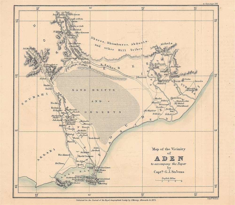
Map of the vicinity of Aden to accompany the paper by Captn. G. J. Stevens.
1873 (dated) 7.25 x 7.75 in (18.415 x 19.685 cm) 1 : 250000
1873 (dated) 7.25 x 7.75 in (18.415 x 19.685 cm) 1 : 250000
Description
This is an 1873 map of Aden, Yemen and its surroundings engraved by Edward Weller and published by the firm John Murray for the The Journal of the Royal Geographical Society. The map accompanied an article written by Captain G. J. Stevens of his travels through these lands.
The Dharee, Dhumberee, and other 'hill tribes' identified here had recently fallen into disputes with the Sultanate and other powerful local rulers over water rights, disputes in which the British became entangled in 1866. Stevens refers several times to the lingering effects of destruction wrought by British troops during an expedition that year, with many of the areas destroyed in 1866 being abandoned instead of rebuilt. He also mentions Bedouins inhabiting the mountains who were beyond the writ of any ruler. In the background of these complicated local politics was the relationship between the British and the Ottomans (Lahij and Aden itself were fought over in the opening months of World War I (1914 - 1918) though the campaign resulted in a stalemate).
A Closer Look
This map depicts the area surrounding Aden, a recently acquired British territory that was becoming an important piece in Britain's global empire at this time (see below). Naturally, the British were both interested in and concerned about the surrounding territory, which belonged to the Sultanate of Lahej (Lahij). The article which this map accompanied, written by Captain G. J. Stevens, describes a foray of British troops and local guides to explore the surrounding area and call on local grandees. The prevalence of water, state of roads, nature of society, and economic activity of the areas visited are all described in detail, much of which is also indicated here.The Dharee, Dhumberee, and other 'hill tribes' identified here had recently fallen into disputes with the Sultanate and other powerful local rulers over water rights, disputes in which the British became entangled in 1866. Stevens refers several times to the lingering effects of destruction wrought by British troops during an expedition that year, with many of the areas destroyed in 1866 being abandoned instead of rebuilt. He also mentions Bedouins inhabiting the mountains who were beyond the writ of any ruler. In the background of these complicated local politics was the relationship between the British and the Ottomans (Lahij and Aden itself were fought over in the opening months of World War I (1914 - 1918) though the campaign resulted in a stalemate).
British Aden
Due to its strategic location and importance as a trading port, Aden has been coveted by a series of historical empires, including Ming China (the 'treasure fleet' admiral Zheng He visited in 1419), the Portuguese, and the Ottomans. Its prosperity faded in the 17th and 18th centuries, but it retained it cosmopolitan character as a home to Jews, Somalis, and Indians in addition to local Arab tribes. The British were ceded a portion of territory by the Ottoman-aligned Sultan (Sultanate of Lahej) in the late 1830s and established a protectorate over the surrounding territory, concurrent with much of today's Yemen. Initially the British were interested in stopping piracy, but over time they came to see Aden as a strategic asset against potential competitors in Arabia and the Middle East. The East India Company also viewed it as a useful stop on the way to India, while holding trade potential in its own right. Aden was declared a free port in 1850 and trade quickly boomed, with Aden overtaking Mokha as the main port for exporting coffee. The development of steam powered ships also made Aden a convenient coaling station, and its importance grew significantly with the opening of the Suez Canal. In its later years, Aden, more specifically 'Little Aden,' also became a site for petroleum refining.Publication History and Census
This map was engraved by Edward Weller to accompany the article 'Report on the country around Aden' in Vol. 43 of The Journal of the Royal Geographical Society of London, published in 1873 by John Murray. The map is only known to be cataloged among the holdings of Princeton University and has no known history on the market.CartographerS
John Murray I (1737 - 1793) founded the British publishing firm John Murray (1768 - present) in London. Born in Edinburgh, Murray served as an officer in the Royal Marines and built a list of authors that included Isaac D’Israeli and published the English Review. Murray the elder also was one of the founding sponsors of the London evening newspaper The Star in 1788. John Murray II (November 27 1778 - June 27, 1843) continued the family publishing business and developed it into one of the most important and influential publishing houses in Britain. The list of authors published by the firm grew to include Jane Austen, Sir Walter Scott, Washington Irving, George Crabbe, and Lord Byron under his tenure. Murray II also moved the business to 50 Albermarle Street in Mayfair, which became famous for Murray’s tradition of ‘four o’clock friends’, which was afternoon tea with his writers. John Murray III (1808 - 1892) continued to grow the business, and the firm published the first English translation of Goethe’s Theory of Colours, David Livingstone’s Missionary Travels and Charles Darwin’s Origin of Species during his tenure. Murray also published Herman Melville’s first two books. The firm began publishing Murray Handbooks in 1836, an ancestor of all modern travel guides. Sir John Murray IV (1851 - 1928) was publisher to Queen Victoria. Three successive Murray’s after Murray IV led the business until it was purchased by Hodder Headline in 2002, which was acquired by the French conglomerate Lagardère Group in 2004. Today, Murray is an imprint of Lagardère under the imprint Hachette UK. More by this mapmaker...
Edward Weller (July 1, 1819 - 1884) was a cartographer and engraver based in London. Weller was a nephew of another well-known map publisher Sidney Hall (1788 - 1831), who gave him 50 Pounds to pay his apprenticeship fees. He engraved for many prominent mapmakers and was active enough in the community to be recommended for membership to the Royal Geographical Society in 1851 on the recommendation of John Arrowsmith, among others. He eventually inherited the Sidney Hall map business which led him to follow Arrowsmith as the unofficial geographer to the Royal Geographical Society. Weller was among the first map printers in London to embrace lithography. His best known work appears in Cassell's Weekly Dispatch Atlas, published in monthly segments for subscribers of the 'Weekly Dispatch' newspaper. This collection of maps eventually grew to include much of the known world. Published in various editions from 1855 through the early 1880s. Weller died in May of 1884, leaving behind a successful business and an unhappy widow. His son, Francis Sidney Weller (1849 - 1910), followed in his father's footsteps and continued the family map business. The atlas Mackenzie's Comprehensive Gazetteer of England and Wales was published in 1894 and bore F. S. Weller's signature on the maps. Learn More...
Royal Geographical Society (fl. 1830 - present) is a British Society established in 1830 to promote geographical science and exploration. Originally titled the "Geographical Society of London", the RGS received its royal charter from Queen Victoria in 1859 shortly after absorbing several similar but more regional societies including the African Association, the Raleigh Club and the Palestine Association. The RGS sponsored many of the most important and exciting voyages of exploration ever undertaken, including the exploration of Charles Darwin, David Livingstone, Robert Falcon Scott, Richard F. Burton, John Speke, George Hayward, H. M Stanley, Ernest Shackleton and Sir Edmond Hillary. Today, the RGS remains a leading global sponsor of geographical and scientific studies. The Society is based in Lowther Lodge, South Kensington, London. Learn More...
Condition
Very good. Some offsetting present.