
1914 Matthews-Northrup Map of the Adirondack Region, New York

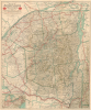
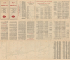
Map of the Adirondack Mountains showing How to Reach Them by the New York Central Lines / Map of the Adirondacks and List of Hotels, Boarding Houses...
Weaving Rails through the Adirondack Wilderness.
- Digital Map Information
- Suitable for large format printing
- Full resolution TIFF file
- ICC color profile embedded
- Delivered instantly via download link
Weaving Rails through the Adirondack Wilderness.
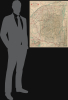
This is a large-format 1914 map of the Adirondack region, prepared by Matthews-Northrup for the New York Central Railroad. At this time, the New York Central had a near-monopoly on the Adirondacks, which had become a favorite destination for elite clientele from New York and other cities in the eastern U.S. and Canada.A Closer Look
The map covers a wide portion of Upstate New York, from Montreal and the St. Lawrence River in the north to Albany in the south, and as far west as Jefferson and Oswego Counties in the west to the Hudson River and Lake Champlain in the east. The lines of the New York Central system, including subsidiaries and areas with track-sharing agreements with other lines, are traced in bold red lines. Other rail systems are traced in thinner black lines and differentiated as either steam or electric, while 'stage lines,' highways, wagon trails, foot paths, steamship routes, and canoe routes are traced. The boundaries of counties are outlined in blue, while the border of the Adirondack Park is marked by a line of small crosses, faintly shaded. Cities, towns, villages, rail stations, lakes, ponds, mountains, and hotels are indicated throughout. An inset at bottom-left displays the entire New York Central System, reaching as far as St. Louis and Chicago in the west and Boston in the east.The verso includes fare information for the summer of 1914, a list of major resorts and lakes with their elevation above sea level, details on the different rail lines of the New York Central and its partners operating in the Adirondack region, extensive information on different resorts and hotels with their rates, nearest train station, open season, policies on children, and more
Vast, Verdant Vacationland
Verplanck Colvin and the Adirondack Survey provided the first accurate surveys of the vast Adirondacks region in the 1870s. These, in turn, led to the creation of the Forest Preserve and Adirondack Park, a 6.1-million-acre park in upstate New York that encompasses more than 10,000 lakes, 30,000 miles of streams and rivers, and an estimated 200,000 acres of old-growth forests. Better knowledge about the region and its protection, along with expanding railway infrastructure, cleared the way for the Adirondacks to become a premier destination for wealthy urbanites and convalescents from New York City and elsewhere who sought refuge in the region's natural splendor.Several railroads were launched in the late 19th century to connect the Adirondacks with major cities along the coast, including the Chateaugay Railroad, which reached Loon Lake in 1886 and Sarnac Lake in 1887, linking to the Delaware and Hudson system, and the Mohawk and Malone Railway (founded 1892), which weaved through the Adirondacks to Montreal. In the following years, through agreements and mergers, the New York Central incorporated these lines into its growing empire, offering the extremely convenient link directly to Grand Central Terminal in New York City. Though the New York Central had controlled the Mohawk and Malone Railway since 1893 (the Mohawk and Malone having been founded by William Seward Webb, an in-law of the Vanderbilt family, which headed the New York Central), this map appeared just one year after it was formally incorporated into the New York Central as the 'Adirondack Division.' Passenger service on the Adirondack Division ended in 1968, but was periodically revived for tourist purposes, including during the 1980 Winter Olympics at Lake Placid, and today the nonprofit Adirondack Railroad heritage railway operates weekend service between Utica and Tupper Lake.
Publication History and Census
This map was prepared by Matthews-Nortrup Works in Buffalo, New York, in 1914, in conjunction with Poole Bros., who are credited on the verso. The map is undated, but the date can be reliably inferred from the fare schedule on the verso. Multiple editions of the map exist, but since the map itself is not dated and most catalog listings infer a date, establishing a complete census is tricky. However, two institutions infer a date of 1914 in their catalog listings and describe verso content matching that here: the University of Wisconsin - Milwaukee and the American Museum of Natural History.Cartographers
Matthews-Northrup Works (fl. c. 1895 - 1930) were a Buffalo, New York based, in their own words, "writing, designing, engraving, printing, [and] binding" firm. The firm was founded by James Newson Matthews (November 21, 1828 - December 20, 1888) as the J. N. Matthews Company. William Phelps Northrup (April 2, 1850 - February 2, 1929) later joined the company as an apprentice and then partner, at which point the firm was reincorporated as the Matthews-Northrup Works. The Matthews-Northrup Works rose to prominence as publishers and printers of railroad maps, with dozens to their credit. When James died, his shares were inhered by George Edward Matthews (1855 - 1910), who ran the business until his death in 1910. Also in 1910, they famously redesigned the cover of National Geographic Magazine. Despite some six previous cover changes in just 21 years, the Matthews-Northrup layout proved so popular that it was used for nearly 50 years. The firm can also take credit for the Winchell typeface, designed in 1903 under E. E. Winchell's tenure as art director. Curiously, the partners of Matthews-Northrup maintained an unusual affectation in which only the officers of the company could wear beards or mustaches. In this same spirit, the firm also had its own private social club, the Fellowcraft Club, where the all-male employees could relax, play pool, drink and dine. Matthews-Northrup maintained offices on Washington Street, Buffalo, where they were based, as well as Madison Square, New York City, Garden Tower, Boston, and the Citizens Building in Cleveland. Further Details...
Poole Brothers (1878 - 1968) were a Chicago based firm active in the late 19th and early 20th century with an initial focus on promotional railroad maps. Poole Brothers was founded by George Amos Poole (March 20, 1843 – September 7, 1918). In 1868, Poole, along with his uncle William H. Rand (1828 - 1915) and Andrew McNally (1836 - 1904), purchased the Chicago Tribune's job printing plant and formed the firm Rand McNally. In 1878, he left Rand McNally to form, with his brother William H. Poole, Poole Brothers, a direct competitor to Rand McNally for the lucrative railroad business. Like many of its competitors, Poole Brothers maintained an office on Chicago's Printer's Row (downtown Loop district). Their earliest known work is an 1880 map of Yellowstone National Park. In 1887, Poole Brothers, Andrew McNally, and several others formed the United Typothetae of America, a master printers association. In 1848, they were cited, along with Rand McNally and George Cram, by the Federal Trade Commission for price fixing. Their earliest known work is an 1880 map of Yellowstone National Park. Afterward they went on to produce a vast range of maps and other print products including tickets, cards, coupons, and restaurant menus. In time Poole Brothers merged with Newman-Randolph, which was then acquired by the American Can Company in the early 1960s. The American Can Company liquidated its printing concerns later in the same decade. Further Details...
Condition
Very good. Slight wear on original fold lines. Archival verso stabilization at stress points.
References
OCLC 70844380.