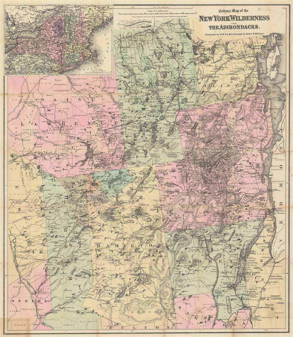
1894 Ely / Colton Map of the Adirondacks, New York
Adirondacks-ely-1894$950.00

Title
Colton's Map of the New York Wilderness and the Adirondacks.
1894 (dated) 31.5 x 27.5 in (80.01 x 69.85 cm) 1 : 253440
1894 (dated) 31.5 x 27.5 in (80.01 x 69.85 cm) 1 : 253440
Description
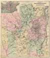
This is Colton's 1894 updated edition of William Watson Ely's map of New York's Adirondack Mountains. Coverage extends from Saint Lawrence, Franklin, and Clinton counties in the north, to parts of Oneida and Saratoga counties in the south. An inset map in the upper left marks the location of the Adirondacks in relation to the rest of New York State, and New England as a whole. Colton's updates to Ely's map were supplied at least in part by Edwin R. Wallace, who included the map in his Descriptive Guide to the Adirondacks, which from its first printings in the 1875 would be the essential guidebook for travelers in the wilderness of northern New York. The present example contains further updates to 1894, some quite specific to the famous Adirondack Great Camps.
The Wilderness of the Adirondacks
With its lush wilderness, rich wildlife, and plethora of lakes and rivers, the Adirondack Mountains were a popular sporting and fishing destination for much of the 19th century. As early as the 1850s it was a favorite stomping ground for such luminaries as James Russell Lowell, Louis Agassiz, and Ralph Waldo Emerson. Nonetheless, it wasn't until 1867 that a reliable map appeared. The Adirondacks' rugged rurality, lakes, mountains, and rivers proved a daunting obstacle for 19th century surveyors and cartographers. The work of Rochester physician and enthusiastic Adirondack sportsman W. W. Ely finally opened this region cartographically. This map, the product of Ely's efforts and experience, was praised by his successor Wallace:To Dr. W. W. Ely, as the pioneer in recording these unmapped portions, and making reasonably plain to those who should follow the devious windings of stream and trail, is due to the gratitude of thousands who have acknowledged the benefit derived from his valuable map of 'the New York wildness,' which, up to the present time, has been the only one worthy of name as such.And indeed Dr. Ely produced a magnificent map. Spacious in size and with a focus on detail, this map notes roads, paths, lakes, rivers, rapids, mines, waterfalls, villages, lodges, and farmsteads throughout the region. As the first reasonably accurate map of the Adirondacks, 'The New York Wilderness' enjoyed an immediately popularity and would continue to be reprinted and edited in various editions for the rest of the 19th century.
The Coltons
The first formal mention of his map appeared in a letter from Ely to his friend Louis H. Morgan, dated August 19, 1866:I shall not admit that the Adirondacks are behind your country I am ahead of you, for the publishers are soliciting my production - the Coltons have applied for my map and I am playing coy. They want the contribution but do not think the investment would be remunerative, but would publish, I would give it to them. If they will give me due credit for Authorship, I think I will let them have the map, but not to use for the purpose of compilation and take all the glory to themselves.Ely must have come to some understanding with the Colton's, for the map was first published one year later 1867. Nonetheless, Ely was correct in his fears that the publishers would take all credit for the map, as many later editions removed Ely's name from the cover and title.
The Updates
The present state of the map shows a far more accessible Adirondacks than Ely's 1867 map. Where even the 1869 edition only contained two railroads penetrating partway into the wild - the partially constructed Whitehall and Plattesburg, and the incomplete, Hudson-River-hugging Adirondack Railroad. By the time this 1894 edition was produced railways reached every county except Hamilton. Some of the most famous of the Great Camps, such as Long Lake's faux-rustic Sagamore, have been included in the present edition. Areas formerly difficult to reach and ill mapped, such as the Fulton Chain of lakes, have been completely reworked. Private grants of land, such as the Brandreth Park family-owned forest preserve with its Shingle Shanty Preserve are marked on the map as well.Inscription
The map, twice, bears the name we transcribe as H. E. Shumway, who may have been the Horatio Shumway who contemporaneously with this map's publication was a Utica physician. It would not be odd for a doctor from Utica to do occasional rounds through the neighboring wilderness, and at any rate his profession would certainly explain his inscrutable handwriting.Census and Publication History
This iteration of the map, narrowed to focus on the Adirondack counties, was updated and reissued in a format entitled New York Wilderness and the Adirondacks by G. W. and C. B. Colton, from their 312 Broadway address, in and around 1870. Starting in 1875 it would be included in Edwin R. Wallace's Descriptive Guide to the Adirondacks, in whose many editions it would continue to appear with updates.CartographerS
Joseph Hutchins Colton (July 5, 1800 - July 29, 1893), often publishing as J. H. Colton, was an important American map and atlas publisher active from 1833 to 1897. Colton's firm arose from humble beginnings when he moved to New York in 1831 and befriended the established engraver, Samuel Stiles. He worked under Stiles as the 'Co.' in Stiles and Co. from 1833 to 1836. Colton quickly recognized an emerging market in railroad maps and immigrant guides. Not a cartographer or engraver himself, Colton's initial business practice mostly involved purchasing the copyrights of other cartographers, most notably David H. Burr, and reissuing them with updated engraving and border work. His first maps, produced in 1833, were based on earlier Burr maps and depicted New York State and New York City. Between 1833 and 1855, Colton proceeded to publish a large corpus of guidebooks and railroad maps, which proved popular. In the early 1850s, Colton brought his two sons, George Woolworth Colton (1827 - 1901) and Charles B. Colton (1832 - 1916), into the map business. G. W. Colton, trained as a cartographer and engraver, was particularly inspired by the idea of creating a large and detailed world atlas to compete with established European firms for the U.S. market. In 1855, G.W. Colton issued volume one of the impressive two-volume Colton's Atlas of the World. Volume two followed a year later. Possibly because of the expense of purchasing a two-volume atlas set, the sales of the Atlas of the World did not meet Colton's expectations, and so, in 1856, the firm also issued the atlas as a single volume. The maps contained in this superb work were all original engravings, and most bear an 1855 copyright. All of the maps were surrounded by an attractive spiral motif border that would become a hallmark of Colton's atlas maps well into the 1880s. In 1857, the slightly smaller Colton's General Atlas replaced the Atlas of the World. Most early editions of the General Atlas published from 1857 to 1859 do not have the trademark Colton spiral border, which was removed to allow the maps to fit into a smaller format volume. Their customers must have missed the border because it was reinstated in 1860 and remained in all subsequent publications of the atlas. There were also darker times ahead; in 1858, Colton was commissioned at a sum of 25,000 USD by the government of Bolivia to produce and deliver 10,000 copies of a large format map of that country. Although Colton completed the contract in good faith, delivering the maps at his own expense, he was never paid by Bolivia, which was at the time in the midst of a series of national revolutions. Colton would spend the remainder of his days fighting with the Bolivian and Peruvian governments over this payment, and in the end, after a congressional intervention, he received as much as 100,000 USD in compensation. Nonetheless, at the time, it was a disastrous blow. J. H. Colton and Company is listed as one of New York's failed companies in the postal record of 1859. This led Colton into the arms of Alvin Jewett Johnson and Ross C. Browning. The 1859 edition of Colton's General Atlas lists Johnson and Browning as the 'Successor's to J. H. Colton' suggesting an outright buyout, but given that both companies continued to publish separately, the reality is likely more complex. Whatever the case may have been, this arrangement gave Johnson and Browning access to many of Colton's map plates and gave birth to Johnson's New Illustrated (Steel Plate) Family Atlas. The Johnson's Atlas was published parallel to Colton's atlases well into the 1880s. The Colton firm itself subsequently published several other atlases including an Atlas of America, the Illustrated Cabinet Atlas, the Octavo Atlas of the Union, and Colton's Quarto Atlas of the World. They also published a large corpus of wall maps, pocket maps, and guides. The last known publications of the Colton firm date to 1897 and include a map and a view, both issued in association with the Merchant's Association of New York. Alice M. Colton married August R. Ohman (May 3, 1859 - April 22, 1934) on January 5, 1897. In 1898, Ohman joined the Colton firm, which continued to publish as Colton, Ohman & Co. until 1901. More by this mapmaker...
William Watson Ely (April 30, 1812 - March 27, 1879) was a Rochester, New York physician, wilderness enthusiast, and hobbyist mapmaker. Ely was born in Fairfield, Connecticut, and studied medicine at Yale, graduating in 1834. He married shortly afterward and established a medical practice at Manlius, Onondaga County, New York. He relocated his practice to the larger city of Rochester in 1839, where he remained for the remainder of his days. Despite his success as a doctor, Ely is best remembered for his remarkable mapping of the Adirondacks, completed between 1860 and 1866. His meticulous work produced the first accurate map of the Adirondacks and was the definitive map of that region for some 20 years. Ely died in Rochester of heart disease in 1879. Learn More...
Condition
Good. Wear along original fold lines. Infill at every fold intersection. Manuscript signatures on recto near title.
References
OCLC: 977340525. Marshall, G., 'Dr. Ely and his Adirondack Map,' New York History Vol. 35, No. 1 (January 1954), pp. 32-48. Stoddard, Seneca Roy, The Adirondacks, page 7.