This item has been sold, but you can get on the Waitlist to be notified if another example becomes available, or purchase a digital scan.
1700 François Halma Map of Africa
Africa-halma-1700$1,750.00

Title
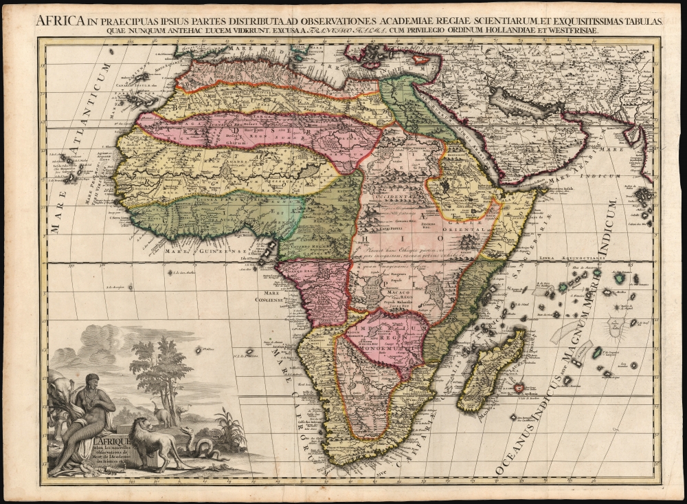
L'Afrique selon les nouvelles observations de Mssrs de l'Académie des sciences, etc., Africa in praecipuas ipsius partes distributa, ad observationes academiae regiae scientarum et exquisitissimas tabulas quae nunquam antehac lucen vederunt, Excusa A Francisco Halma, cum privilegio ordinum Hollandiae et westfrisiae.
1700 (undated) 19.75 x 26.5 in (50.165 x 67.31 cm) 1 : 18520000
1700 (undated) 19.75 x 26.5 in (50.165 x 67.31 cm) 1 : 18520000
Description
This is the rare first state of François Halma's c. 1699 separately-issued map of Africa. Its unusually large folio size, bold and sophisticated engraving, and rich original color sets this map apart as one of the most beautiful obtainable late-17th century maps of the continent.
A Closer Look
The map dramatically presents some of the most notable geographic conventions of its era, including the placement of Lake Tana as the source of the Blue Nile and the separation of the Nile from Lakes Zaire and Zaflan - which since Ptolemaic times were assumed to be its source. The map is surprising in its apparent originality, and its immediate precursors are not completely obvious.Inner Niger Delta
The true course of the Niger River was not understood by Europeans until well into the 19th century. Typically, 16th and 17th-century maps depicted the Niger flowing into Senegal, east to west, with its source deep in central Africa (in reality, it flows from western Africa to the northeast before turning south and emptying into the Gulf of Guinea.) In spite of this error, apparent here, the reality of the Inner Niger Delta was beginning to emerge. In most earlier maps, the Niger River splits, then rejoins in the regions of 'Gangara' and 'Zanfara,' forming an enormous island. De Fer's 1698 wall map of Africa fills in this space, indicating a lake or marsh, corresponding approximately with the Inland Delta - an element preserved in this map.The Ptolemaic Lakes
Most maps of the 17th century, including those of the Sanson-Du Val lineage, present Lakes Zaire and Zaflan as the source of the Nile, a geographical assumption reaching back to Ptolemy. Pierre Du Val's 1678 4-sheet map of the continent is the first to diverge from this trope, correctly identifying Lake Tana as the source of the Blue Nile and disassociating the White Nile from the Ptolemaic lakes. This correction was not universally adopted - those who did adopt the corrections included De Fer, de la Croix, Nolin, and Coronelli. Here, Halma's presentation of the Blue Nile takes after De Fer.Flacourt's Madagascar
The geography of Madagascar and its surrounding islands also places this map in the lineage of Sanson and other French cartographers of the late 17th century. Fort Dauphin is marked on the southeast coast of Madagascar. This settlement first shows up in Etienne de Flacourt's map, then in the maps of Sanson and Du Val. By the end of the 17th century, the convention was adopted by Halma and other Dutch mapmakers. A bay on the west coast of Madagascar, Ance de Mansiatre, is presented distinctively. This, too, traces to Flacourt's map.Imaginary Islands
South of the island of Apollonia (Isle de Bourbon) is an imaginary island named 'Dos Romeiros dos Castillianos' (from the Portuguese, the Pilgrim's islands of the Spanish).The Prime Suspect
On balance, the key geographical features of the map bear the closest resemblance to the geography of De Fer's maps beginning in 1698. Halma did not follow De Fer in his delineation of the coastline - especially eschewing De Fer's puzzling treatment of the Cape of Good Hope. It is likely that the many peculiarities of Halma's coastline may represent an attempt to reconcile De Fer's cartography to more conventional presentations of the continent.A Magnificent Baroque Cartouche
The title cartouche is illustrated inscribed on a stone block, on which is seated a female representation of Africa. Ivory tusks lie at her feet, as do two medallions bearing pharaonic imagery. The foreground is occupied by dangerous animals: a lion, two snakes, and a tremendous scorpion. Elephants can be recognized in the mountainous, forested background.Publication History and Census
The map was printed by François Halma, probably after 1699. It was composed by Jan Goeree and engraved by the unjustly obscure J. Baptist. Halma produced no full-size atlas of his own, but this map was accompanied by similarly grand maps of Asia, America, and Europe, and likely Halma's 1696 north polar projection world after Cassini. Before 1713, the plates were acquired by Leiden map publisher Pieter van der Aa, who replaced Halma's imprints with his own and included the maps in his 1713 Le Nouveau Théâtre du Monde. Halma's separately issued maps, destined for decorative use or tipping into composite atlases by other publishers, have survived in only a few examples. We are aware of only one other example of this edition of this map coming to the market, and there is but a single example cataloged in OCLC, tipped into a Visscher atlas now held by the Newberry Library.CartographerS
François Halma (1653 - 1722) was a Dutch publisher active in Utrecht (starting 1674) and later in Amsterdam where he worked as printer and publisher from 1699-1710. He eventually settled at Leeuwarden, where he died. His output was composed of botanical, theological and historical works, but also, he published a small number of geographies and atlases. In 1695, he published an edition of Gerard Mercator's Ptolemy. His re-issue of Schotanus à Sterringa’s Friesche Atlas in 1698 was regarded among his finest work. He also published an edition of Sanson’s Description de l’Univers. He produced an edition of Falda's plan of Rome in or around 1700. He also caused to be engraved a set of large-format maps of the continents and the world (this latter after Cassini) which are quite rare and appear to have been separately issued. We are aware of institutional copies of the continents having been bound into a 1710 Visscher atlas. The execution of these large and rare maps, drawn by Jan Goeree and engraved by Jan Baptiste, was of a very high quality. The plates were later acquired and reprinted, virtually unchanged, by Pieter van der Aa in 1713. More by this mapmaker...
Jan Goeree (1670 - 1731) was a Dutch painter, draughtsman and printmaker. He was also known as a poet. He was the son of one Willem Goeree and no details come down to us of his youth in Middleburg. In Amsterdam he was a pupil of Dutch Golden Age painter and art theorist Gerard de Lairesse. He lived out his life in Amsterdam, the city in which most of his work was produced. His engraving appeared in De Fer's Atlas Royal. Tooley's Dictionary is probably mistaken in saying he worked for Pieter van der Aa. Although his imprint is to be found on van der Aa's large format maps, these were executed on behalf of François Halma as early as 1694, and the plates later acquired and reprinted by van der Aa in 1713. Learn More...
J. Baptist (active late 17th century) was an engraver active in the Netherlands in the latter part of the 17th century and possibly into the early 18th. We see his imprint virtually only in the work of François Halma (any connection with the later work of Pieter van der Aa is extremely tenuous; as the Aa plates attributed to Baptist were actually executed on behalf of Halma and later purchased by the Leiden publisher.) Learn More...
Nicholas de Fer (1646 - October 25, 1720) was a French cartographer and publisher, the son of cartographer Antoine de Fer. He apprenticed with the Paris engraver Louis Spirinx, producing his first map, of the Canal du Midi, at 23. When his father died in June of 1673 he took over the family engraving business and established himself on Quai de L'Horloge, Paris, as an engraver, cartographer, and map publisher. De Fer was a prolific cartographer with over 600 maps and atlases to his credit. De Fer's work, though replete with geographical errors, earned a large following because of its considerable decorative appeal. In the late 17th century, De Fer's fame culminated in his appointment as Geographe de le Dauphin, a position that offered him unprecedented access to the most up to date cartographic information. This was a partner position to another simultaneously held by the more scientific geographer Guillaume De L'Isle, Premier Geograph de Roi. Despite very different cartographic approaches, De L'Isle and De Fer seem to have stepped carefully around one another and were rarely publicly at odds. Upon his death of old age in 1720, Nicolas was succeeded by two of his sons-in-law, who also happened to be brothers, Guillaume Danet (who had married his daughter Marguerite-Geneviève De Fer), and Jacques-François Bénard (Besnard) Danet (husband of Marie-Anne De Fer), and their heirs, who continued to publish under the De Fer imprint until about 1760. It is of note that part of the De Fer legacy also passed to the engraver Remi Rircher, who married De Fer's third daughter, but Richer had little interest in the business and sold his share to the Danet brothers in 1721. Learn More...
Étienne de Flacourt (1607 – 1660) was a French governor of Madagascar, born at Orléans in 1607. He was French East India Company's governor of Madagascar in 1648. In 1658 he authored L'Histoire de le Grand île de Madagascar, the first detailed natural history of the island, for which he prepared a map which represented the first improvement on the geographical knowledge of the island since Linschoten. Flacourt was one of the few, if not the only, Westerner to have recorded knowledge of the elephant birds of Madagascar when they were possibly still extant. Learn More...
Condition
Very good. Few marginal mends away from printed image, some creasing around upper centerfold, else excellent with a bold strike, attendant to the youth of the plate. Superb original color.
References
OCLC 925491142.