
This item below is out of stock, but another example (left) is available. To view the available item, click "Details."
Details
1818 Pinkerton Map of Northern Africa and the Mediterranean
1818 (undated) $300.00
1818 Pinkerton Map of Africa
Africa-pinkerton-1818$225.00

Title
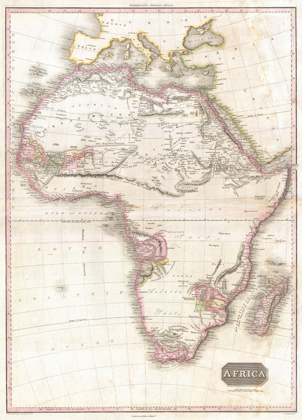
Africa.
1818 (undated) 28 x 20.5 in (71.12 x 52.07 cm)
1818 (undated) 28 x 20.5 in (71.12 x 52.07 cm)
Description
This is John Pinkerton's stunning 1818 map of Africa. Nineteenth century mapmakers were particularly challenged by the difficult task of deciphering Africa. Despite a fairly constant flow of information about the continent dating to the middle ages, much of the interior remained speculative at best. Pinkerton, straying from the path of his 18th century predecessors chooses to leave much of the interior blank and instead focuses known areas, or more precisely, areas perceived to be known. These include Mediterranean North Africa, Egypt, Abyssinia, the western Niger valley, the Congo, South Africa, and the lands of Monomotapa (Zimbabwe).
Each of these regions have their own unique history of European contact. Egypt, along the Nile, had been well mapped even in Antiquity. The same is true of Christian Abysinnia who, through regular contact with the Coptic mother church in Egypt, was well known, if mostly unexplored by Europeans. The tale of European incursion and occupation of South Africa could easily encompass volumes and explains Pinkerton's sophisticated mapping of this area. The Niger Valley and the Congo had been simultaneously exploited and explored by Portugal and later Belgium since the 1300s.
Monomotapa, opposite the island of Madagascar, was a major stopping point on the Portuguese trade routes to India. Curiously this region has also been associated with King Solomon's Mines and Biblical legends of the Land of Ophir. Pinkerton doesn't specifically mention the Kingdom of Monomotapa, or Mutapa, which by this time had long fallen into decline, but he does he does identify several of its constituent states including Manica, Sabia, and Sofala, as well as the 'Rich Gold Mines' supposedly found there. In truth this area was rich in gold, in the 1300s, but by the time the Europeans arrived, most of the mines had been tapped out.
The remaining parts of the map are frequently quite vague. Pinkerton does note several important and recognizable African tribal groups including the Bushman of the Kalahari (Booshmanas), the Hottentots, the Massai, and others. North of the Monomotapa region we can find Lake Maravi, a long narrow lake oriented on a north-south axis. This lake, with its northern extremis speculatively ghosted, most likely represents Lake Malawi or Lake Tanganyika, or both. Curiously, just to the east of Maravi, Pinkerton maps an interesting apocryphal mountain range which he call the 'Backbone of the World.' This range has variously been associated with the Mountains of the Moon, described by the 5th century Alexandrian geographer Claudius Ptolemy, and another independent range described by Arab cartographers. Regardless, the 'Backbone of the World,' at least as it applies to this part of Africa, never existed. Further north though, Pinkerton does map the 'Mountains of the Moon,' which were said by Ptolemy to lie near two great lakes that were at the source of the White Nile. Today some regard this range and its lakes as speculative, but more likely it represents Ptolemy's very real knowledge of Lake Victoria and the Rwenzori Mountains. In any case Pinkerton makes the curious decision not to map the Ptolemaic Lakes, though does maintain the Mountains of the Moon, placing the source of the Nile there. To the west of the Mountains of the Moon Pinkerton draws a long mountain range called the 'Kong Mountains.' This speculative was proposed by the explorations of Mungo Parks and were presumed to be the southern barrier to the Niger River valley. All in all, this is a spectacular map that stands up to hours of close examination - a fascinating addition to any Africa collection.
Drawn by L. Herbert and engraved by Samuel Neele under the direction of John Pinkerton. This map was issued in the scarce American edition of Pinkerton's Modern Atlas, published by Thomas Dobson & Co. of Philadelphia in 1818.
CartographerS
John Pinkerton (February 17, 1758 - March 10, 1826) was an Scottish writer, historian, and cartographer. Pinkerton was born in Edinburgh, Scotland. He was a studious youth with a passion for the classics. As a young man, he studied at Edinburgh University before apprenticing as a lawyer. Around this time, he began writing, with his first book, Elegy on Craigmillar Castle published in 1776. Pinkerton moved to London in 1781 to pursue his writing career in earnest. He successfully published several works of literature, poetry, and history. Pinkerton proved passionate in his literary and historical writings, but his correspondence with other cartographers has been labeled as aggressive, even insane. In addition to his work as a writer and historian, Pinkerton was one of the leading masters of the Edinburgh school of cartography which flourished from roughly 1800 to 1830. Pinkerton and his contemporaries (Thomson and Cary) redefined European cartography by abandoning typical 18th century decorative elements such as elaborate title cartouches and fantastical beasts in favor of detail and accuracy. Pinkerton's principle work is Pinkerton's Modern Atlas published from 1808 through 1815 with a special American reissue by Dobson and Co. in 1818. Pinkerton relocated to Paris in 1818, where he managed his publishing business until his death in 1826. More by this mapmaker...
Thomas Dobson (1751 - 1823) was an American publisher active in Philadelphia during the late 18th and early 19th centuries. Dobson was born in Edinburgh, Scotland in 1751 and emigrated to Philadelphia c. 1780. In Philadelphia, he established a successful printing business by republishing edited and updated versions of important British reference materials in matching quality but at a much lower price point. He is best known for publishing the first American edition of the Encyclopedia Britannica. He also published America's first Hebrew Bible. Cartographically Dobson's most notable work is 1818 republication of Pinkerton's fantastic Modern Atlas. Learn More...
Source
Pinkerton, J., A Modern Atlas, from the Lates and Best Authorities, Exhibiting the Various Divisions of the World with its chief Empires, Kingdoms, and States; in Sixty Maps, carefully reduced from the Larges and Most Authentic Sources. 1818, Philadelphia, Thomas Dobson Edition.
Condition
Good. Minor dampstaining in the right hand quadrants. Else clean. Blank on verso.
References
Rumsey 0732.056 (British edition). Phillips (Atlases) 724. National Maritime Museum, 409.