This item has been sold, but you can get on the Waitlist to be notified if another example becomes available, or purchase a digital scan.
1890 Royal Geographical / Stanford Map of Africa (Scramble for Africa)
Africa-royalgeographical-1890$325.00

Title
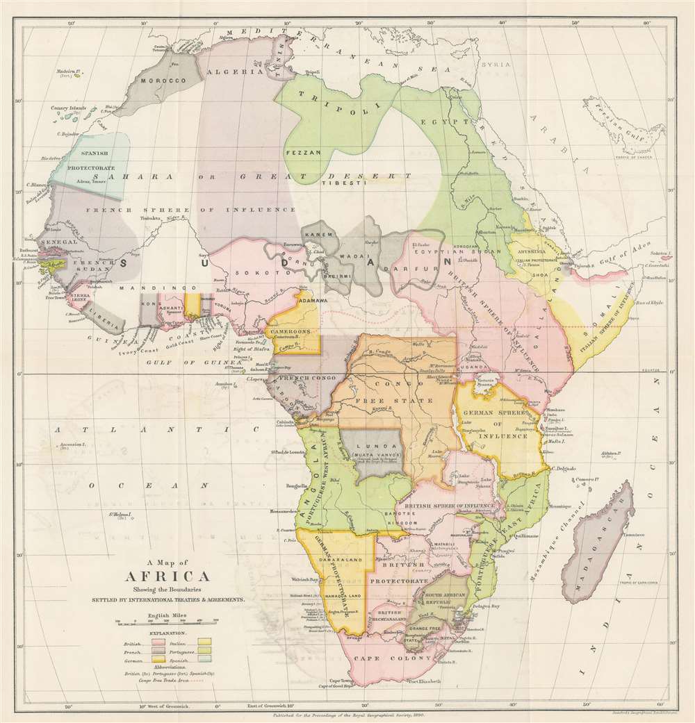
A Map of Africa Showing the Boundaries Settled by International Treaties and Agreements.
1890 (dated) 17 x 16 in (43.18 x 40.64 cm) 1 : 126720
1890 (dated) 17 x 16 in (43.18 x 40.64 cm) 1 : 126720
Description
This is an 1890 Edward Stanford and Royal Geographical Society map of Africa. The map was created as a visual summary of the international treaties and agreements governing the partition of Africa by the European powers. Various colors correspond with different European spheres of influence: British territory is pink, while French territory is purple, etc. Portuguese, Italian, German, and Spanish claims are also delineated. 'Independent' nations supposedly free of European influence / suzerainty are colored black. The Congo Free State, which roughly corresponds with today's Democratic Republic of the Congo, is shaded orange and is not referenced as being claimed by any specific country as it was personally owned by King Leopold II of Belgium.
Per the Royal Geographical Society
The map is explained in these terms by the accompanying article published in the Proceedings of the Royal Geographical Society, November 1890:Now that the greater part of Africa has been parcelled out among the European Powers, it may be useful to indicate what the limits of the claims of each of these powers, and on what these claims are based. It has been sought to show in the accompanying map the boundaries of the claims of the various Powers, so far as these have been settled by international agreement. Where the space has been left blank it is because there is no express agreement, or the limits have been left vague intentionally by the Powers concerned, or the particular districts are so far independent. An unbordered wash of colour is intended to signify that the area indicated is left to the undisputed operations of one Power.
Scramble for Africa
The map is an artifact of the 'Scramble for Africa,' the series of late 19th and early 20th century occupations, usurpations, annexations, divisions, and land seizures by European powers in Africa. The Scramble for Africa was mainly characterized by heightened occupation and direct ownership of colonial lands. Rivalries and treaties led to a number of new African states, many of which remain, but few of which paid heed to traditional boundaries or cultural distinctions. The Scramble culminated in the Berlin Conference of 1884, wherein European colonization of Africa was made official and the doctrine of Effective Occupation introduced.Berlin Conference of 1884-85 / Congo Conference / West Africa Conference
The 1884-85 Berlin Conference was a meeting of colonial powers in Berlin during the New Imperialism Period. The resultant 'General Act of the Berlin Conference' is considered to be the formalization of the 'Scramble for Africa', wherein much of Africa was partitioned between major European powers (with little regard to the claims and priorities of the indigenous peoples). In order to claim territory, the delegates needed to prove 'effective occupation.' This means they needed to establish the existence of treaties with local powers, show that their flags were being flown, or have active forts in the region. The conference marked a major change in the European approach to Africa. Initially European powers treated African peoples much like Native Americans, establishing trading relationships and alliances with indigenous kingdoms. After the Berlin Conference, heightened colonial activity and the need to prove effective occupation led to the subjugation of most indigenous control.Publication History and Census
This map was created and published by Edward Stanford for the Royal Geographical Society in the November 1890 edition of the Proceedings of the Royal Geographical Society. We note three examples cataloged in OCLC which are part of the collections at the the Newberry Library, the British Library, and the Bibliothèque nationale de France.CartographerS
Edward Stanford (May 27, 1827 - November 3, 1904) was one of the most prolific map publishing firms of the late 19th century. The company began as a partnership in 1848 between the 21 year old Edward Stanford and the established map dealer Trelawney Saunders. By 1853 the partnership had dissolved and Edward Stanford took full control of the business. A subsequent series of expansions and exciting new map issues finally led to the production of Stanford's masterwork, "Stanford's Library Map of London". This map is still available and remains somewhat accurate. At the time of publishing it was hailed by the Royal Geographical Society as "the most perfect map of London that has ever been issued". In 1882 Edward Stanford Sr. passed the firm on to his son, Edward Stanford Jr. who continued in his father's proud tradition. Today the Stanford firm still publishes maps and remains one of the most important and prolific cartographic publishers in the world. More by this mapmaker...
Royal Geographical Society (fl. 1830 - present) is a British Society established in 1830 to promote geographical science and exploration. Originally titled the "Geographical Society of London", the RGS received its royal charter from Queen Victoria in 1859 shortly after absorbing several similar but more regional societies including the African Association, the Raleigh Club and the Palestine Association. The RGS sponsored many of the most important and exciting voyages of exploration ever undertaken, including the exploration of Charles Darwin, David Livingstone, Robert Falcon Scott, Richard F. Burton, John Speke, George Hayward, H. M Stanley, Ernest Shackleton and Sir Edmond Hillary. Today, the RGS remains a leading global sponsor of geographical and scientific studies. The Society is based in Lowther Lodge, South Kensington, London. Learn More...
Source
Royal Geographical Society, 'The Partition of Africa', Proceedings of the Royal Geographical Society Vol. XII, No. XI. (London: Edward Stanford) 1890.
Condition
Very good. Exhibits light wear along original fold lines. Some offsetting.
References
OCLC 1029354175; 707397673; 556209708.